TopoQuest Logo
Do you find TopoQuest useful?
Help keep TopoQuest running and adding new maps/features by donating!
Bitcoin:  19c7KJd3qBynnjoSw5npx9KScwjBe4ifkT
Litecoin:  LXs6TkuXGGXo1vDsWCkWVdjQX94eUKd6ui
Home View Maps Find Maps Find Places Resources & Links


Nawakwa Lake, Michigan Topographic Map

USGS Map Title: Nawakwa Lake, MI
USGS Map MRC: 46085E8
DRG (GeoTIFF) Download: o46085e8.tif


Neighboring USGS Topographic Map Quads:


  Grand Sable Lake, MI  
46086F1
 

  Grand Marais, MI  
46085F8
 

  Grand Marais NE, MI  
46085F7
 

  Au Sable Point SE, MI  
46086E1
 

  Nawakwa Lake, MI  
46085E8
 

  Grand Marais SE, MI  
46085E7
 

  Sunken Lake, MI  
46086D1
 

  Seney NW, MI  
46085D8
 

  Tahquamenon Lakes, MI  
46085D7


Map MRC Location:

N47°
W86°
N47°
W85°
H8 H7 H6 H5 H4 H3 H2 H1
G8 G7 G6 G5 G4 G3 G2 G1
F8 F7 F6 F5 F4 F3 F2 F1
E8 E7 E6 E5 E4 E3 E2 E1
D8 D7 D6 D5 D4 D3 D2 D1
C8 C7 C6 C5 C4 C3 C2 C1
B8 B7 B6 B5 B4 B3 B2 B1
A8 A7 A6 A5 A4 A3 A2 A1
N46°
W86°
N46°
W85°

Nawakwa Lake, MI USGS 1:24K Topographic Map Preview:
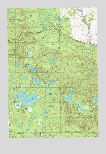
Nawakwa Lake, MI USGS Topographic Map
Click on map above to begin viewing in our Map Viewer.

This topographic map contains these locations and features:
Feature Name Type Latitude Longitude GNIS ID View Map
Ames LakeLakeN46.5249°W85.9474°620061View Map
Blood CreekStreamN46.6041°W85.9415°621605View Map
Bluegill LakeLakeN46.5419°W85.9444°621653View Map
County Line LakeLakeN46.5054°W85.9997°623892View Map
East LakeLakeN46.5317°W85.9888°625213View Map
Grand Marais AirportAirportN46.6205°W85.9221°1623923View Map
Harvey CreekStreamN46.5867°W85.8846°627902View Map
Haverstock CreekStreamN46.6044°W85.9457°627949View Map
Horseshoe LakeLakeN46.5536°W85.9449°628626View Map
Johns LakesLakeN46.5274°W85.9024°629319View Map
Kennedy LakeLakeN46.5517°W85.9435°629588View Map
Klondike CreekStreamN46.5964°W85.9207°629798View Map
Lavender CornerPopulated PlaceN46.5016°W85.9399°630199View Map
Line LakeLakeN46.5640°W85.9563°630512View Map
Mellen LakeLakeN46.5280°W85.9781°632083View Map
Mitchell LakeLakeN46.5386°W85.9141°632519View Map
Mud LakeReservoirN46.5004°W85.9921°633058View Map
Nawakwa LakeLakeN46.5380°W85.9712°633239View Map
Newton LakeLakeN46.5542°W85.9350°633382View Map
Niemi LakeLakeN46.5706°W85.9735°633404View Map
North LakeLakeN46.5372°W85.8758°633599View Map
Palmer LakeLakeN46.5337°W85.9929°634316View Map
Porter CreekStreamN46.5894°W85.8810°635300View Map
Section Seventeen LakeLakeN46.5539°W85.9525°637536View Map
Sitka LakeLakeN46.5749°W85.9370°638019View Map
Sleeper LakeLakeN46.5306°W85.9384°638095View Map
Spring CreekStreamN46.6019°W85.9729°638556View Map
Sullivan CreekStreamN46.5458°W85.9829°639034View Map
Sullivan LakeLakeN46.5540°W85.9602°639042View Map
Weber LakeLakeN46.5643°W85.9651°1615945View Map
West Branch Sucker RiverStreamN46.5933°W85.9854°1616077View Map
Youngs Post Office (historical)Post OfficeN46.5053°W85.9689°2352355View Map
Youngs Station (historical)LocaleN46.5053°W85.9689°2352356View Map

Note: Coordinates in the location and feature list above are referenced to NAD83 datum.


Copyright (C) 2008-2025 Ryan Niemi / Sunset Dynamics ... All Rights Reserved