TopoQuest Logo
Do you find TopoQuest useful?
Help keep TopoQuest running and adding new maps/features by donating!
Bitcoin:  19c7KJd3qBynnjoSw5npx9KScwjBe4ifkT
Litecoin:  LXs6TkuXGGXo1vDsWCkWVdjQX94eUKd6ui
Home View Maps Find Maps Find Places Resources & Links


Nestorville, West Virginia Topographic Map

USGS Map Title: Nestorville, WV
USGS Map MRC: 39079B8
DRG (GeoTIFF) Download: o39079b8.tif


Neighboring USGS Topographic Map Quads:


  Grafton, WV  
39080C1
 

  Thornton, WV  
39079C8
 

  Fellowsville, WV  
39079C7
 

  Philippi, WV  
39080B1
 

  Nestorville, WV  
39079B8
 

  Colebank, WV  
39079B7
 

  Audra, WV  
39080A1
 

  Belington, WV  
39079A8
 

  Montrose, WV  
39079A7


Map MRC Location:

N40°
W80°
N40°
W79°
H8 H7 H6 H5 H4 H3 H2 H1
G8 G7 G6 G5 G4 G3 G2 G1
F8 F7 F6 F5 F4 F3 F2 F1
E8 E7 E6 E5 E4 E3 E2 E1
D8 D7 D6 D5 D4 D3 D2 D1
C8 C7 C6 C5 C4 C3 C2 C1
B8 B7 B6 B5 B4 B3 B2 B1
A8 A7 A6 A5 A4 A3 A2 A1
N39°
W80°
N39°
W79°

Nestorville, WV USGS 1:24K Topographic Map Preview:
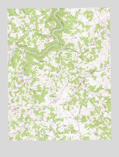
Nestorville, WV USGS Topographic Map
Click on map above to begin viewing in our Map Viewer.

This topographic map contains these locations and features:
Feature Name Type Latitude Longitude GNIS ID View Map
ArdenPopulated PlaceN39.2104°W79.9931°1535001View Map
Arden Truss BridgeBridgeN39.2106°W79.9942°2635269View Map
Arden United Methodist ChurchChurchN39.2093°W79.9931°1696993View Map
Big Cove RunStreamN39.2473°W79.9373°1550290View Map
Big RunStreamN39.1684°W79.9006°1535929View Map
Bonica RunStreamN39.1570°W79.9709°1536219View Map
Boyle School (historical)SchoolN39.1548°W79.9759°1697013View Map
Brushy ForkStreamN39.1843°W79.9095°1550504View Map
Camp Valley ChurchChurchN39.1782°W79.9129°1536964View Map
Central Chapel ChurchChurchN39.1323°W79.9159°1537161View Map
Chester Coffman SpringSpringN39.2495°W79.9040°1677982View Map
Chester Coffman SpringSpringN39.2484°W79.9026°1677983View Map
Chestnut Grove School (historical)SchoolN39.2012°W79.8859°1697027View Map
ClemtownPopulated PlaceN39.2326°W79.9773°1554146View Map
Clemtown School (historical)SchoolN39.2345°W79.9781°1697033View Map
Corinth ChurchChurchN39.1495°W79.8834°1537688View Map
Cove RunPopulated PlaceN39.2454°W79.9331°1697039View Map
Cove Run Station (historical)Populated PlaceN39.2473°W79.9367°1697040View Map
Crossroads ChurchChurchN39.1654°W79.9417°1537875View Map
Croston School (historical)SchoolN39.1618°W79.9959°1537877View Map
Cunningham RunStreamN39.2243°W79.9445°1537916View Map
Dantown (historical)Populated PlaceN39.1559°W79.9667°1697045View Map
Danville School (historical)SchoolN39.2232°W79.8751°1697046View Map
Evangelical Bible ChurchChurchN39.1768°W79.9307°2711513View Map
Fairview CemeteryCemeteryN39.1984°W79.9606°1697054View Map
Fairview ChurchChurchN39.1987°W79.9604°1538821View Map
Felton School (historical)SchoolN39.1884°W79.9973°1697056View Map
Flat RunStreamN39.1782°W79.9087°1539058View Map
Frost RunStreamN39.1851°W79.9817°1539280View Map
Glade RunStreamN39.2109°W79.9331°1539431View Map
Glade RunStreamN39.2426°W79.9431°1539433View Map
Glady CreekStreamN39.1415°W79.9548°1539445View Map
Hoffman School (historical)SchoolN39.1895°W79.9381°1540342View Map
Jimmy RunStreamN39.1609°W79.8898°1551573View Map
KalamazooPopulated PlaceN39.1415°W79.9159°1549767View Map
KassonPopulated PlaceN39.2248°W79.8754°1554845View Map
Kasson Elementary / Middle SchoolSchoolN39.2286°W79.8784°1697091View Map
Kasson Post OfficePost OfficeN39.2248°W79.8751°1697092View Map
Laurel CreekStreamN39.2098°W79.9776°1541409View Map
Laurel Grove ChurchChurchN39.1851°W79.9826°1541473View Map
Mariahs ChurchChurchN39.2343°W79.9790°1542759View Map
Mill RunStreamN39.1654°W79.8942°1552136View Map
Mitchell RunStreamN39.2104°W79.9945°1543471View Map
Moats HollowValleyN39.1993°W79.9751°1543474View Map
MoatsvillePopulated PlaceN39.2104°W79.9331°1543473View Map
Moatsville Post OfficePost OfficeN39.1970°W79.9177°1697126View Map
Moatsville School (historical)SchoolN39.2095°W79.9337°1697127View Map
Mount Beulah SchoolSchoolN39.2151°W79.9762°1543613View Map
Mount Contention Schoolhouse (historical)SchoolN39.2215°W79.9651°1697129View Map
Mount Zion ChurchChurchN39.1298°W79.8923°1543832View Map
NestorvillePopulated PlaceN39.1798°W79.9092°1555200View Map
Nestorville School (historical)SchoolN39.1857°W79.9106°1697138View Map
New Hope Valley ChurchChurchN39.1965°W79.8784°1544128View Map
New Moatsville (historical)Populated PlaceN39.2176°W79.9379°1697139View Map
North DistrictCivilN39.1923°W79.9548°1928323View Map
Old Dutch ChurchChurchN39.2068°W79.8892°1544351View Map
Olive Hill CemeteryCemeteryN39.1534°W79.9904°1544398View Map
Olive Hill ChurchChurchN39.1618°W79.9959°1544399View Map
Olive Hill School (historical)SchoolN39.1529°W79.9898°1697141View Map
Phelps School (historical)SchoolN39.2212°W79.9184°1544776View Map
Philippi Christian Academy (historical)SchoolN39.1770°W79.9307°2088308View Map
Pritchard ChurchChurchN39.2429°W79.9604°1545278View Map
Pritchard School (historical)SchoolN39.2426°W79.9604°1545280View Map
Raccoon CreekStreamN39.2073°W79.9154°1552574View Map
Riverdale School (historical)SchoolN39.2226°W79.9487°1697172View Map
Rock Ford ChurchChurchN39.1437°W79.9604°1545906View Map
Rock Ford School (historical)SchoolN39.1432°W79.9548°1697173View Map
Saint Johns ChurchChurchN39.1848°W79.9417°1546241View Map
Sand RunStreamN39.1320°W79.9615°1546375View Map
Sand Run School (historical)SchoolN39.1323°W79.9626°1546378View Map
Souls Harbor ChurchChurchN39.2151°W79.8992°1547059View Map
Stony RunStreamN39.2484°W79.9370°1547506View Map
Sugar CreekStreamN39.1568°W79.9709°1547632View Map
TacyPopulated PlaceN39.1620°W79.9420°1547869View Map
Teter CreekStreamN39.2182°W79.9376°1553197View Map
Tom Hardin SpringSpringN39.2284°W79.8834°1677984View Map
Tygart LakeReservoirN39.2132°W79.9845°1548442View Map
Valley FurnacePopulated PlaceN39.1951°W79.8767°1555868View Map
Vannoys MillPopulated PlaceN39.1307°W79.9584°1553342View Map
White Oak ChurchChurchN39.1457°W79.9156°1549047View Map
White Oak School (historical)SchoolN39.1462°W79.9148°1697205View Map
Wolf RunStreamN39.2137°W79.9904°1549291View Map

Note: Coordinates in the location and feature list above are referenced to NAD83 datum.


Copyright (C) 2008-2024 Ryan Niemi / Sunset Dynamics ... All Rights Reserved