TopoQuest Logo
Do you find TopoQuest useful?
Help keep TopoQuest running and adding new maps/features by donating!
Bitcoin:  19c7KJd3qBynnjoSw5npx9KScwjBe4ifkT
Litecoin:  LXs6TkuXGGXo1vDsWCkWVdjQX94eUKd6ui
Home View Maps Find Maps Find Places Resources & Links


New Goshen, Indiana Topographic Map

USGS Map Title: New Goshen, IN
USGS Map MRC: 39087E4
DRG (GeoTIFF) Download: o39087e4.tif


Neighboring USGS Topographic Map Quads:


  Saint Bernice, IN  
39087F5
 

  Clinton, IN  
39087F4
 

  Mecca, IN  
39087F3
 

  Sandford, IN  
39087E5
 

  New Goshen, IN  
39087E4
 

  Rosedale, IN  
39087E3
 

  Dennison, IL  
39087D5
 

  Terre Haute, IN  
39087D4
 

  Seelyville, IN  
39087D3


Map MRC Location:

N40°
W88°
N40°
W87°
H8 H7 H6 H5 H4 H3 H2 H1
G8 G7 G6 G5 G4 G3 G2 G1
F8 F7 F6 F5 F4 F3 F2 F1
E8 E7 E6 E5 E4 E3 E2 E1
D8 D7 D6 D5 D4 D3 D2 D1
C8 C7 C6 C5 C4 C3 C2 C1
B8 B7 B6 B5 B4 B3 B2 B1
A8 A7 A6 A5 A4 A3 A2 A1
N39°
W88°
N39°
W87°

New Goshen, IN USGS 1:24K Topographic Map Preview:
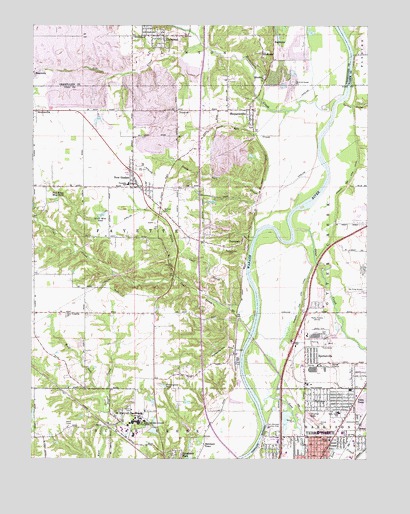
New Goshen, IN USGS Topographic Map
Click on map above to begin viewing in our Map Viewer.

This topographic map contains these locations and features:
Feature Name Type Latitude Longitude GNIS ID View Map
Alcan Aluminum Fire BrigadeBuildingN39.5362°W87.3970°2626622View Map
Barbour CemeteryCemeteryN39.5711°W87.4508°430484View Map
Barnhart TownPopulated PlaceN39.5039°W87.4356°430517View Map
Bethlehem ChurchChurchN39.6217°W87.4625°430981View Map
Brouilletts CreekStreamN39.6048°W87.3848°403294View Map
Brouilletts CreekStreamN39.6042°W87.3853°449860View Map
Clinton Sand PitMineN39.6169°W87.4072°2635780View Map
Coal CreekStreamN39.5406°W87.4170°432705View Map
Crystal LakeReservoirN39.5123°W87.3958°433230View Map
DeweyPopulated PlaceN39.5095°W87.3759°433522View Map
Farmer LakeReservoirN39.5666°W87.4284°447775View Map
Farmers Lake Dam EastDamN39.5667°W87.4267°447774View Map
Fort Harrison (historical)MilitaryN39.5083°W87.4111°452237View Map
Fort Harrison Country ClubLocaleN39.5098°W87.4100°452324View Map
Grant Mine PondLakeN39.5700°W87.4744°435326View Map
HarrisonPopulated PlaceN39.5286°W87.4222°452218View Map
Lost CreekStreamN39.5142°W87.4139°438315View Map
Lost Creek Conservation Club LakeReservoirN39.5334°W87.4984°448758View Map
Lost Creek Conservation Club Lake DamDamN39.5334°W87.4984°448757View Map
NeedmorePopulated PlaceN39.6189°W87.4103°439975View Map
New GoshenPopulated PlaceN39.5811°W87.4622°440049View Map
New Goshen Census Designated PlaceCensusN39.5830°W87.4646°2583461View Map
New Goshen Fire and RescueBuildingN39.5758°W87.4579°2626429View Map
New Vermillion ChurchChurchN39.5420°W87.4872°440122View Map
North Coal CreekStreamN39.5442°W87.4253°440237View Map
North Salt CreekStreamN39.6006°W87.4059°440291View Map
Otter CreekStreamN39.5664°W87.4020°440738View Map
ParkviewPopulated PlaceN39.5164°W87.3920°440899View Map
Pennington PondReservoirN39.5213°W87.4508°440998View Map
Pine RidgePopulated PlaceN39.5792°W87.4917°446683View Map
Pine Ridge Mine PondReservoirN39.5752°W87.4908°452481View Map
Pleasantview CemeteryCemeteryN39.5609°W87.4253°441355View Map
Pottsville HillSummitN39.5306°W87.4300°441510View Map
Rankin SchoolSchoolN39.5056°W87.3889°441769View Map
RhodesPopulated PlaceN39.6095°W87.4131°441928View Map
Saint Mary of the Woods Census Designated PlaceCensusN39.5120°W87.4628°2583468View Map
Saint Mary of the Woods Lake DamDamN39.5084°W87.4534°448759View Map
Saint Mary-of-the-WoodsPopulated PlaceN39.5109°W87.4672°442687View Map
Saint Mary-of-the-Woods CollegeSchoolN39.5106°W87.4611°449725View Map
Saint Marys LakeReservoirN39.5081°W87.4545°448760View Map
ShepardsvillePopulated PlaceN39.6009°W87.4175°443357View Map
Shepardsville Census Designated PlaceCensusN39.6017°W87.4264°2631623View Map
Shepardsville Census Designated PlaceCensusN39.6017°W87.4264°2631345View Map
Shepardsville Volunteer Fire DepartmentBuildingN39.5976°W87.4187°2625900View Map
ShirkievillePopulated PlaceN39.6003°W87.4986°443419View Map
South Salt CreekStreamN39.5653°W87.4167°443848View Map
SpeltervillePopulated PlaceN39.5278°W87.3984°443933View Map
Spring CreekStreamN39.6034°W87.3839°443969View Map
Sugar Creek Fire Department Station 42BuildingN39.5121°W87.4683°2625864View Map
Sycamore ParkParkN39.5011°W87.4461°444515View Map
SyndicatePopulated PlaceN39.6173°W87.4142°444528View Map
TecumsehPopulated PlaceN39.5631°W87.4217°444612View Map
Tecumseh Census Designated PlaceCensusN39.5658°W87.4327°2629776View Map
Terre Haute Fire Department Station 7BuildingN39.5071°W87.3974°2626158View Map
Terre TownPopulated PlaceN39.5175°W87.3753°444649View Map
Terre Town Elementary SchoolSchoolN39.5134°W87.3859°444650View Map
Town of UniversalCivilN39.6225°W87.4553°2397706View Map
Township of FayetteCivilN39.5664°W87.4680°453293View Map
Trinity ChurchChurchN39.6000°W87.4450°444898View Map
UniversalPopulated PlaceN39.6217°W87.4514°445146View Map
West New GoshenPopulated PlaceN39.5709°W87.4806°446684View Map
Wolf CreekStreamN39.5134°W87.4711°446238View Map
WPFR-FM (Terra Haute)TowerN39.5498°W87.4767°448967View Map
WZZQ-FM (Terra Haute)TowerN39.5036°W87.4436°448968View Map

Note: Coordinates in the location and feature list above are referenced to NAD83 datum.


Copyright (C) 2008-2025 Ryan Niemi / Sunset Dynamics ... All Rights Reserved