TopoQuest Logo
Do you find TopoQuest useful?
Help keep TopoQuest running and adding new maps/features by donating!
Bitcoin:  19c7KJd3qBynnjoSw5npx9KScwjBe4ifkT
Litecoin:  LXs6TkuXGGXo1vDsWCkWVdjQX94eUKd6ui
Home View Maps Find Maps Find Places Resources & Links


Clinton, Indiana Topographic Map

USGS Map Title: Clinton, IN
USGS Map MRC: 39087F4
DRG (GeoTIFF) Download: o39087f4.tif


Neighboring USGS Topographic Map Quads:


  Scottland, IL  
39087G5
 

  Dana, IN  
39087G4
 

  Montezuma, IN  
39087G3
 

  Saint Bernice, IN  
39087F5
 

  Clinton, IN  
39087F4
 

  Mecca, IN  
39087F3
 

  Sandford, IN  
39087E5
 

  New Goshen, IN  
39087E4
 

  Rosedale, IN  
39087E3


Map MRC Location:

N40°
W88°
N40°
W87°
H8 H7 H6 H5 H4 H3 H2 H1
G8 G7 G6 G5 G4 G3 G2 G1
F8 F7 F6 F5 F4 F3 F2 F1
E8 E7 E6 E5 E4 E3 E2 E1
D8 D7 D6 D5 D4 D3 D2 D1
C8 C7 C6 C5 C4 C3 C2 C1
B8 B7 B6 B5 B4 B3 B2 B1
A8 A7 A6 A5 A4 A3 A2 A1
N39°
W88°
N39°
W87°

Clinton, IN USGS 1:24K Topographic Map Preview:
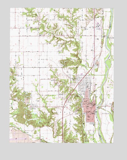
Clinton, IN USGS Topographic Map
Click on map above to begin viewing in our Map Viewer.

This topographic map contains these locations and features:
Feature Name Type Latitude Longitude GNIS ID View Map
Andrews CemeteryCemeteryN39.7431°W87.4675°430171View Map
CentenaryPopulated PlaceN39.6584°W87.4734°432301View Map
Center ChurchChurchN39.7098°W87.4606°432320View Map
Central Elementary SchoolSchoolN39.6584°W87.4072°447537View Map
City of ClintonCivilN39.6607°W87.4046°2393567View Map
ClintonPopulated PlaceN39.6570°W87.3981°432671View Map
Clinton AirportAirportN39.7108°W87.3994°449123View Map
Clinton Fire DepartmentBuildingN39.6606°W87.3995°2626410View Map
Clinton Gun ClubLocaleN39.6348°W87.4036°452294View Map
Clinton Police DepartmentBuildingN39.6608°W87.3994°2758404View Map
Clinton Township Fire DepartmentBuildingN39.6580°W87.4735°2626403View Map
Crompton HillPopulated PlaceN39.6559°W87.4192°433146View Map
Ernie Pyle SchoolSchoolN39.7250°W87.4639°446855View Map
Fairview ParkPopulated PlaceN39.6803°W87.4175°434349View Map
Fairview Park Volunteer Fire DepartmentBuildingN39.6833°W87.4086°2626456View Map
Fairview SchoolSchoolN39.6809°W87.4078°434353View Map
Feather CreekStreamN39.6767°W87.3909°434425View Map
Glendale Elementary SchoolSchoolN39.6703°W87.4097°435112View Map
Hall CemeteryCemeteryN39.6253°W87.4727°435613View Map
Helts Prairie CemeteryCemeteryN39.7311°W87.4112°435999View Map
Higbie CemeteryCemeteryN39.7314°W87.4756°436130View Map
HudnutPopulated PlaceN39.6595°W87.3770°436569View Map
KlondykePopulated PlaceN39.6695°W87.4367°437381View Map
Matthews-South Elementary SchoolSchoolN39.6495°W87.4034°438717View Map
McDonald LakeLakeN39.6688°W87.4167°438854View Map
Norton CreekStreamN39.6875°W87.3847°440354View Map
Riverside CemeteryCemeteryN39.6675°W87.3978°442109View Map
Sacred Heart SchoolSchoolN39.6539°W87.4034°442447View Map
Salem ChurchChurchN39.7320°W87.3992°442913View Map
SandytownPopulated PlaceN39.6820°W87.4461°443014View Map
Spangler CemeteryCemeteryN39.6650°W87.4943°443906View Map
Sportland ParkParkN39.6523°W87.4097°443960View Map
Summit GrovePopulated PlaceN39.7245°W87.3892°444396View Map
Town of Fairview ParkCivilN39.6821°W87.4142°2396933View Map
Township of ClintonCivilN39.6512°W87.4603°453234View Map
Union Hospital ClintonHospitalN39.6529°W87.3990°2660466View Map
Van Duyn SchoolSchoolN39.6639°W87.4650°446856View Map
Vermillion County Emergency Medical Services Station 2BuildingN39.6569°W87.4179°2719334View Map
Walnut Grove CemeteryCemeteryN39.6742°W87.4005°445424View Map

Note: Coordinates in the location and feature list above are referenced to NAD83 datum.


Copyright (C) 2008-2025 Ryan Niemi / Sunset Dynamics ... All Rights Reserved