TopoQuest Logo
Do you find TopoQuest useful?
Help keep TopoQuest running and adding new maps/features by donating!
Bitcoin:  19c7KJd3qBynnjoSw5npx9KScwjBe4ifkT
Litecoin:  LXs6TkuXGGXo1vDsWCkWVdjQX94eUKd6ui
Home View Maps Find Maps Find Places Resources & Links


New Haven, New York Topographic Map

USGS Map Title: New Haven, NY
USGS Map MRC: 43076D3
DRG (GeoTIFF) Download: o43076d3.tif


Neighboring USGS Topographic Map Quads:


  West of Texas, NY  
43076E4
 

  Texas, NY  
43076E3
 

  Pulaski, NY  
43076E2
 

  Oswego East, NY  
43076D4
 

  New Haven, NY  
43076D3
 

  Mexico, NY  
43076D2
 

  Fulton, NY  
43076C4
 

  Pennellville, NY  
43076C3
 

  Central Square, NY  
43076C2


Map MRC Location:

N44°
W77°
N44°
W76°
H8 H7 H6 H5 H4 H3 H2 H1
G8 G7 G6 G5 G4 G3 G2 G1
F8 F7 F6 F5 F4 F3 F2 F1
E8 E7 E6 E5 E4 E3 E2 E1
D8 D7 D6 D5 D4 D3 D2 D1
C8 C7 C6 C5 C4 C3 C2 C1
B8 B7 B6 B5 B4 B3 B2 B1
A8 A7 A6 A5 A4 A3 A2 A1
N43°
W77°
N43°
W76°

New Haven, NY USGS 1:24K Topographic Map Preview:
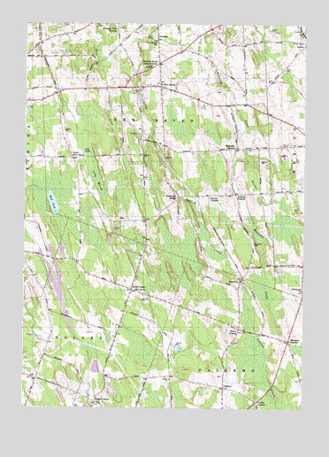
New Haven, NY USGS Topographic Map
Click on map above to begin viewing in our Map Viewer.

This topographic map contains these locations and features:
Feature Name Type Latitude Longitude GNIS ID View Map
Arthur CemeteryCemeteryN43.4860°W76.2589°969828View Map
Austins CornersLocaleN43.4442°W76.2930°969834View Map
Behling OrchardsLocaleN43.4439°W76.2744°2542309View Map
Butterfly CemeteryCemeteryN43.4595°W76.2753°2542503View Map
Butterfly CornersLocaleN43.4595°W76.2805°969939View Map
CliffordPopulated PlaceN43.3817°W76.2852°970013View Map
Clifford CemeteryCemeteryN43.3810°W76.2875°2542502View Map
Community Alliance ChurchChurchN43.4780°W76.3080°2714719View Map
Cribbs CornerPopulated PlaceN43.3773°W76.2697°973232View Map
Cummings BridgeLocaleN43.4440°W76.3069°970053View Map
DemsterPopulated PlaceN43.4962°W76.3169°970068View Map
Demster Grove Camp GroundLocaleN43.4856°W76.3194°970069View Map
Drakes CornerPopulated PlaceN43.3767°W76.3424°973234View Map
First Congregational ChurchChurchN43.4801°W76.3164°2714731View Map
Jacobson FarmsLocaleN43.4053°W76.3572°2542334View Map
Johnson CornersLocaleN43.4448°W76.2808°970251View Map
Lily MarshSwampN43.4492°W76.3424°970288View Map
Lily PondLakeN43.4586°W76.3457°970289View Map
Maple Help Stock FarmsLocaleN43.4442°W76.2581°2542312View Map
Mud PondLakeN43.4415°W76.3622°970382View Map
Mullen HillSummitN43.4459°W76.2702°970391View Map
Mungers CornersPopulated PlaceN43.3970°W76.2566°970392View Map
New HavenPopulated PlaceN43.4798°W76.3152°970403View Map
New Haven Elementary SchoolSchoolN43.4802°W76.3213°2713739View Map
New Haven Rural CemeteryCemeteryN43.4780°W76.3129°2542504View Map
New Haven StationLocaleN43.4948°W76.3166°970404View Map
New Haven United Methodist ChurchChurchN43.4789°W76.3131°2542505View Map
New Haven Volunteer Fire DepartmentBuildingN43.4786°W76.3111°2734956View Map
North VolneyPopulated PlaceN43.4134°W76.3269°973237View Map
North Volney CemeteryCemeteryN43.4117°W76.3217°2542528View Map
Pleasant Point CrossingPopulated PlaceN43.4987°W76.3344°973238View Map
SalaPopulated PlaceN43.4359°W76.3310°973239View Map
Sayles CornersLocaleN43.4009°W76.2788°970585View Map
Sayles Corners CemeteryCemeteryN43.4003°W76.2772°2368553View Map
School Number 1 (historical)SchoolN43.3972°W76.2569°2368554View Map
School Number 1 (historical)SchoolN43.4781°W76.3597°2368562View Map
School Number 10 (historical)SchoolN43.4134°W76.3249°975733View Map
School Number 10 (historical)SchoolN43.3831°W76.2961°2368842View Map
School Number 11 (historical)SchoolN43.4108°W76.3739°2368843View Map
School Number 2 (historical)SchoolN43.4564°W76.3542°2368565View Map
School Number 3 (historical)SchoolN43.4453°W76.2700°2368568View Map
School Number 3 (historical)SchoolN43.4939°W76.3681°2368570View Map
School Number 3 (historical)SchoolN43.4933°W76.2503°2368572View Map
School Number 5 (historical)SchoolN43.3844°W76.3692°2368825View Map
School Number 5 (historical)SchoolN43.4789°W76.3189°2368826View Map
School Number 6 (historical)SchoolN43.4442°W76.3031°2368828View Map
School Number 7 (historical)SchoolN43.4903°W76.3067°2368831View Map
School Number 9 (historical)SchoolN43.4364°W76.3211°2368841View Map
South New HavenPopulated PlaceN43.4565°W76.3535°970634View Map
Town of New HavenCivilN43.4743°W76.3155°979265View Map
VermilionPopulated PlaceN43.4170°W76.2777°970740View Map
Vermilion CemeteryCemeteryN43.4285°W76.2726°970741View Map
WellwoodPopulated PlaceN43.4134°W76.2505°970754View Map

Note: Coordinates in the location and feature list above are referenced to NAD83 datum.


Copyright (C) 2008-2024 Ryan Niemi / Sunset Dynamics ... All Rights Reserved