TopoQuest Logo
Do you find TopoQuest useful?
Help keep TopoQuest running and adding new maps/features by donating!
Bitcoin:  19c7KJd3qBynnjoSw5npx9KScwjBe4ifkT
Litecoin:  LXs6TkuXGGXo1vDsWCkWVdjQX94eUKd6ui
Home View Maps Find Maps Find Places Resources & Links


Pennellville, New York Topographic Map

USGS Map Title: Pennellville, NY
USGS Map MRC: 43076C3
DRG (GeoTIFF) Download: o43076c3.tif


Neighboring USGS Topographic Map Quads:


  Oswego East, NY  
43076D4
 

  New Haven, NY  
43076D3
 

  Mexico, NY  
43076D2
 

  Fulton, NY  
43076C4
 

  Pennellville, NY  
43076C3
 

  Central Square, NY  
43076C2
 

  Lysander, NY  
43076B4
 

  Baldwinsville, NY  
43076B3
 

  Brewerton, NY  
43076B2


Map MRC Location:

N44°
W77°
N44°
W76°
H8 H7 H6 H5 H4 H3 H2 H1
G8 G7 G6 G5 G4 G3 G2 G1
F8 F7 F6 F5 F4 F3 F2 F1
E8 E7 E6 E5 E4 E3 E2 E1
D8 D7 D6 D5 D4 D3 D2 D1
C8 C7 C6 C5 C4 C3 C2 C1
B8 B7 B6 B5 B4 B3 B2 B1
A8 A7 A6 A5 A4 A3 A2 A1
N43°
W77°
N43°
W76°

Pennellville, NY USGS 1:24K Topographic Map Preview:
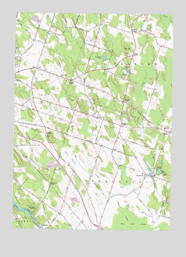
Pennellville, NY USGS Topographic Map
Click on map above to begin viewing in our Map Viewer.

This topographic map contains these locations and features:
Feature Name Type Latitude Longitude GNIS ID View Map
Austin Tree FarmLocaleN43.3542°W76.3661°2542314View Map
Beaver MeadowFlatN43.2870°W76.3247°943398View Map
Beaver Meadows Golf ClubLocaleN43.2903°W76.3170°2715205View Map
Bell CreekStreamN43.2667°W76.2924°969872View Map
Bowen CornersPopulated PlaceN43.3067°W76.2513°944507View Map
Bristol HillSummitN43.3423°W76.3377°944770View Map
Bristol Hill ChurchChurchN43.3384°W76.3385°944771View Map
Camp TalooliLocaleN43.2853°W76.2608°945668View Map
Carousel FarmLocaleN43.3242°W76.3611°2542336View Map
Catalbiano FarmsLocaleN43.2914°W76.3303°2542316View Map
Clark Lane Mobile Home ParkPopulated PlaceN43.2935°W76.2616°2715153View Map
Conifer Mobile Home ParkPopulated PlaceN43.2955°W76.2607°2715154View Map
Emerald Crest Golf CourseLocaleN43.3619°W76.2862°2715207View Map
Farley CornersLocaleN43.3362°W76.3305°949908View Map
Gilbert MillsPopulated PlaceN43.3148°W76.3091°951097View Map
Gilbert Mills CemeteryCemeteryN43.3167°W76.3080°2542513View Map
Goodfellows PondLakeN43.3493°W76.3044°951324View Map
Great Bear SidingLocaleN43.2759°W76.3455°951616View Map
Great Bear SpringsSpringN43.2615°W76.3569°951617View Map
Green Acres Mobile CourtPopulated PlaceN43.3659°W76.3451°2715163View Map
Hidden LakeLakeN43.2823°W76.2563°952708View Map
Ingalls CrossingPopulated PlaceN43.3048°W76.3485°972651View Map
Lake TemaloLakeN43.2840°W76.2595°967128View Map
Loomis CornerPopulated PlaceN43.3512°W76.2819°972740View Map
Maryinuk FarmsLocaleN43.3311°W76.2697°2542326View Map
Oswego County Bristol Hill LandfillLocaleN43.3489°W76.3410°2715147View Map
PalermoPopulated PlaceN43.3651°W76.2824°959773View Map
Palermo CemeteryCemeteryN43.3652°W76.2812°2542512View Map
Palermo United Methodist ChurchChurchN43.3679°W76.2839°2714758View Map
Palermo Volunteer Fire DepartmentBuildingN43.3706°W76.2814°2701169View Map
PennellvillePopulated PlaceN43.2826°W76.2705°960147View Map
Pennellville CemeteryCemeteryN43.2855°W76.2627°960148View Map
Pennellville Post OfficePost OfficeN43.2793°W76.2712°2713530View Map
Pennellville United Methodist ChurchChurchN43.2805°W76.2717°2714761View Map
Pennellville Volunteer Fire DepartmentBuildingN43.2827°W76.2718°2734957View Map
Roosevelt CemeteryCemeteryN43.3071°W76.2546°2542514View Map
Roosevelt ChurchChurchN43.3081°W76.2552°962862View Map
School Number 1 (historical)SchoolN43.3592°W76.3592°2369684View Map
School Number 1 (historical)SchoolN43.3653°W76.2806°2369685View Map
School Number 14 (historical)SchoolN43.2653°W76.3514°2369700View Map
School Number 2 (historical)SchoolN43.3403°W76.3197°2369686View Map
School Number 3 (historical)SchoolN43.2731°W76.3169°2369689View Map
School Number 3 (historical)SchoolN43.3253°W76.2889°2369690View Map
School Number 3 (historical)SchoolN43.3428°W76.3561°2369691View Map
School Number 4 (historical)SchoolN43.2839°W76.3272°2369692View Map
School Number 4 (historical)SchoolN43.3172°W76.3564°2369693View Map
School Number 5 (historical)SchoolN43.3169°W76.3172°2369694View Map
School Number 6 (historical)SchoolN43.3292°W76.2653°2369695View Map
School Number 6 (historical)SchoolN43.3667°W76.3347°2369696View Map
School Number 7 (historical)SchoolN43.2811°W76.2706°2369697View Map
School Number 8 (historical)SchoolN43.2994°W76.3106°2369698View Map
School Number 8 (historical)SchoolN43.3517°W76.3675°2369699View Map
Shepard CornersLocaleN43.3106°W76.2902°965051View Map
Stewarts PondLakeN43.3417°W76.2853°966416View Map
Suttons CornerPopulated PlaceN43.3242°W76.2877°966872View Map
Suttons Corner Gap Filler Annex (historical)MilitaryN43.3547°W76.2861°2091585View Map
Tinkers CemeteryCemeteryN43.3397°W76.2846°965925View Map
Town of PalermoCivilN43.3639°W76.2617°979338View Map
Town of SchroeppelCivilN43.2650°W76.2748°979471View Map
Town of VolneyCivilN43.3594°W76.3732°979589View Map
VolneyPopulated PlaceN43.3428°W76.3577°968599View Map
Volney Center CemeteryCemeteryN43.3417°W76.3522°968600View Map
Volney Rural CemeteryCemeteryN43.3179°W76.3568°2369683View Map
Volney Volunteer Fire Company Station 1BuildingN43.3421°W76.3561°2701061View Map
Woodchuck HillSummitN43.2762°W76.3102°971618View Map

Note: Coordinates in the location and feature list above are referenced to NAD83 datum.


Copyright (C) 2008-2024 Ryan Niemi / Sunset Dynamics ... All Rights Reserved