TopoQuest Logo
Do you find TopoQuest useful?
Help keep TopoQuest running and adding new maps/features by donating!
Bitcoin:  19c7KJd3qBynnjoSw5npx9KScwjBe4ifkT
Litecoin:  LXs6TkuXGGXo1vDsWCkWVdjQX94eUKd6ui
Home View Maps Find Maps Find Places Resources & Links


New River Mesa, Arizona Topographic Map

USGS Map Title: New River Mesa, AZ
USGS Map MRC: 33111H8
DRG (GeoTIFF) Download: o33111h8.tif


Neighboring USGS Topographic Map Quads:


  Squaw Creek Mesa, AZ  
34112A1
 

  Cooks Mesa, AZ  
34111A8
 

  Rover Peak, AZ  
34111A7
 

  Daisy Mountain, AZ  
33112H1
 

  New River Mesa, AZ  
33111H8
 

  Humboldt Mountain, AZ  
33111H7
 

  New River SE, AZ  
33112G1
 

  Cave Creek, AZ  
33111G8
 

  Wildcat Hill, AZ  
33111G7


Map MRC Location:

N34°
W112°
N34°
W111°
H8 H7 H6 H5 H4 H3 H2 H1
G8 G7 G6 G5 G4 G3 G2 G1
F8 F7 F6 F5 F4 F3 F2 F1
E8 E7 E6 E5 E4 E3 E2 E1
D8 D7 D6 D5 D4 D3 D2 D1
C8 C7 C6 C5 C4 C3 C2 C1
B8 B7 B6 B5 B4 B3 B2 B1
A8 A7 A6 A5 A4 A3 A2 A1
N33°
W112°
N33°
W111°

New River Mesa, AZ USGS 1:24K Topographic Map Preview:
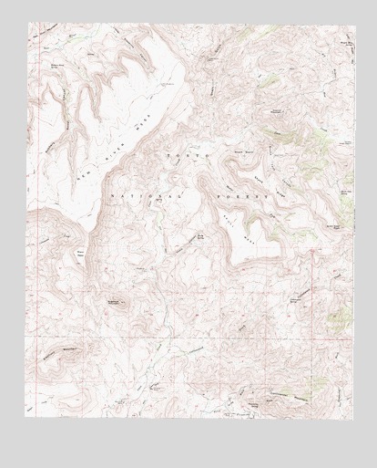
New River Mesa, AZ USGS Topographic Map
Click on map above to begin viewing in our Map Viewer.

This topographic map contains these locations and features:
Feature Name Type Latitude Longitude GNIS ID View Map
Ashdale Administrative SiteLocaleN33.9631°W111.8765°25809View Map
Big Maggie MayStreamN33.9678°W111.8882°26275View Map
Big TankReservoirN33.9489°W111.9756°41271View Map
Black MesaSummitN33.9236°W111.9790°26406View Map
Board SpringSpringN33.9314°W111.9929°36933View Map
Burro SpringSpringN33.9011°W111.9079°41269View Map
Cement SpringSpringN33.9187°W111.9594°41274View Map
Chalk CanyonValleyN33.9264°W111.9477°27479View Map
Chalk SpringSpringN33.9286°W111.9332°36952View Map
Continental MountainSummitN33.8798°W111.8915°27863View Map
Cottonwood CreekStreamN33.8911°W111.9540°28017View Map
Cottonwood SpringSpringN33.9086°W111.9149°2056774View Map
Cottonwood SpringSpringN33.9127°W111.8997°28039View Map
Cramm MountainSummitN33.9725°W111.9027°28155View Map
Division TankReservoirN33.9425°W111.9916°41272View Map
Elephant MountainSummitN33.8956°W111.9829°28850View Map
Flemming SpringSpringN33.8795°W111.9112°29062View Map
Flemming WashStreamN33.8789°W111.9232°29063View Map
Grays GulchValleyN33.9636°W111.9288°29562View Map
Grays Gulch MineMineN33.9889°W111.9321°29563View Map
Lewis SpringSpringN33.9290°W111.9712°41273View Map
LiscumLocaleN33.8848°W111.9513°40468View Map
Little Grapevine CanyonValleyN33.9995°W111.9699°31071View Map
Little Grapevine TankReservoirN33.9811°W111.9498°31072View Map
Little Wonder SpringSpringN33.8966°W111.9299°41915View Map
Lopez TankReservoirN33.9711°W111.9099°41275View Map
Maggie May SpringSpringN33.9941°W111.8764°31441View Map
Maricopa MineMineN33.8800°W111.9624°37027View Map
Mattys ForkStreamN33.9600°W111.9399°31570View Map
Mesa TankReservoirN33.9629°W111.9688°41276View Map
Middle TankReservoirN33.9570°W111.9965°41277View Map
New River MesaSummitN33.9350°W111.9752°32293View Map
New River Mesa TankReservoirN33.9695°W111.9573°41282View Map
Phoenix MineMineN33.8850°W111.9507°32850View Map
Quien Sabe CreekStreamN33.9650°W111.8854°40466View Map
Quien Sabe MineMineN33.9500°W111.8771°40465View Map
Quien Sabe PeakSummitN33.9361°W111.8807°33291View Map
Quien Sabe SpringSpringN33.9470°W111.8807°33292View Map
Reed TankReservoirN33.9544°W111.9980°41278View Map
Road TankReservoirN33.9867°W111.9482°2056776View Map
Robbers Roost CanyonValleyN33.9884°W111.9968°33671View Map
Robbers Roost SpringSpringN33.9850°W111.9913°33673View Map
Rock Tank SpringSpringN33.9103°W111.9246°41916View Map
Ruin TankReservoirN33.9936°W111.9418°2056775View Map
Shulte SpringSpringN33.9326°W111.9351°34396View Map
Skull MesaSummitN33.9259°W111.9151°34493View Map
Skunk BasinBasinN33.9609°W111.9179°34500View Map
Skunk RidgeRidgeN33.9478°W111.9063°34506View Map
Skunk TankReservoirN33.9581°W111.9067°34509View Map
Skunk Tank CanyonValleyN33.9667°W111.9160°34510View Map
Spur Cross Ranch Conservation AreaParkN33.8917°W111.9674°2044823View Map
Sugarloaf MountainSummitN33.9117°W111.9640°34919View Map

Note: Coordinates in the location and feature list above are referenced to NAD83 datum.


Copyright (C) 2008-2025 Ryan Niemi / Sunset Dynamics ... All Rights Reserved