TopoQuest Logo
Do you find TopoQuest useful?
Help keep TopoQuest running and adding new maps/features by donating!
Bitcoin:  19c7KJd3qBynnjoSw5npx9KScwjBe4ifkT
Litecoin:  LXs6TkuXGGXo1vDsWCkWVdjQX94eUKd6ui
Home View Maps Find Maps Find Places Resources & Links


Newark, Nebraska Topographic Map

USGS Map Title: Newark, NE
USGS Map MRC: 40098F8
DRG (GeoTIFF) Download: o40098f8.tif


Neighboring USGS Topographic Map Quads:


  Pleasanton SE, NE  
40099G1
 

  Buckeye Valley, NE  
40098G8
 

  Gibbon North, NE  
40098G7
 

  Kearney, NE  
40099F1
 

  Newark, NE  
40098F8
 

  Gibbon South, NE  
40098F7
 

  Kearney SE, NE  
40099E1
 

  Minden North, NE  
40098E8
 

  Heartwell, NE  
40098E7


Map MRC Location:

N41°
W99°
N41°
W98°
H8 H7 H6 H5 H4 H3 H2 H1
G8 G7 G6 G5 G4 G3 G2 G1
F8 F7 F6 F5 F4 F3 F2 F1
E8 E7 E6 E5 E4 E3 E2 E1
D8 D7 D6 D5 D4 D3 D2 D1
C8 C7 C6 C5 C4 C3 C2 C1
B8 B7 B6 B5 B4 B3 B2 B1
A8 A7 A6 A5 A4 A3 A2 A1
N40°
W99°
N40°
W98°

Newark, NE USGS 1:24K Topographic Map Preview:
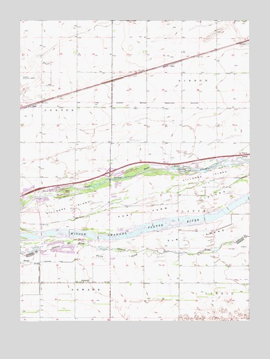
Newark, NE USGS Topographic Map
Click on map above to begin viewing in our Map Viewer.

This topographic map contains these locations and features:
Feature Name Type Latitude Longitude GNIS ID View Map
Bassway Strip State Wildlife Management AreaParkN40.6833°W98.9587°1875135View Map
BudaPopulated PlaceN40.7142°W98.9940°835261View Map
BudaLocaleN40.7142°W98.9940°1875126View Map
Buda Post Office (historical)Post OfficeN40.7142°W98.9940°1875124View Map
Buda School (historical)SchoolN40.7142°W98.9940°1875125View Map
Burlington and Missouri River Railroad Historical MarkerParkN40.6417°W98.9504°1873885View Map
Crooked Creek Drainage DitchCanalN40.6497°W98.9893°828477View Map
Fort Farm IslandIslandN40.6797°W98.8845°829353View Map
Interchange 279CrossingN40.6867°W98.9512°1875366View Map
Kearney Raceway Park Emergency Medical ServicesBuildingN40.7280°W98.9896°2553734View Map
Killgore IslandIslandN40.6778°W98.9467°830497View Map
NewarkPopulated PlaceN40.6411°W98.9631°831613View Map
Newark Post Office (historical)Post OfficeN40.6411°W98.9631°1873794View Map
Rowe SanctuaryParkN40.6700°W98.8851°1875132View Map
School Number 3 (historical)SchoolN40.7283°W98.8929°836529View Map
School Number 4 (historical)SchoolN40.7425°W98.9315°836684View Map
School Number 40SchoolN40.6775°W98.9515°836696View Map
School Number 75SchoolN40.7131°W98.9117°837070View Map
Township of Gibbon (historical)CivilN40.7378°W98.8947°838025View Map
Township of NewarkCivilN40.6331°W98.9898°838155View Map

Note: Coordinates in the location and feature list above are referenced to NAD83 datum.


Copyright (C) 2008-2024 Ryan Niemi / Sunset Dynamics ... All Rights Reserved