TopoQuest Logo
Do you find TopoQuest useful?
Help keep TopoQuest running and adding new maps/features by donating!
Bitcoin:  19c7KJd3qBynnjoSw5npx9KScwjBe4ifkT
Litecoin:  LXs6TkuXGGXo1vDsWCkWVdjQX94eUKd6ui
Home View Maps Find Maps Find Places Resources & Links


Newby, Oklahoma Topographic Map

USGS Map Title: Newby, OK
USGS Map MRC: 35096F3
DRG (GeoTIFF) Download: o35096f3.tif


Neighboring USGS Topographic Map Quads:


  Bristow, OK  
35096G4
 

  Slick, OK  
35096G3
 

  Kiefer SW, OK  
35096G2
 

  Gypsy, OK  
35096F4
 

  Newby, OK  
35096F3
 

  Nuyaka, OK  
35096F2
 

  Welty, OK  
35096E4
 

  Mason, OK  
35096E3
 

  Okfuskee, OK  
35096E2


Map MRC Location:

N36°
W97°
N36°
W96°
H8 H7 H6 H5 H4 H3 H2 H1
G8 G7 G6 G5 G4 G3 G2 G1
F8 F7 F6 F5 F4 F3 F2 F1
E8 E7 E6 E5 E4 E3 E2 E1
D8 D7 D6 D5 D4 D3 D2 D1
C8 C7 C6 C5 C4 C3 C2 C1
B8 B7 B6 B5 B4 B3 B2 B1
A8 A7 A6 A5 A4 A3 A2 A1
N35°
W97°
N35°
W96°

Newby, OK USGS 1:24K Topographic Map Preview:
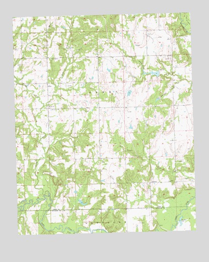
Newby, OK USGS Topographic Map
Click on map above to begin viewing in our Map Viewer.

This topographic map contains these locations and features:
Feature Name Type Latitude Longitude GNIS ID View Map
Beacon Light ChurchChurchN35.7259°W96.3486°1089895View Map
East Fork Sandy CreekStreamN35.6979°W96.3558°1092397View Map
Hopper CreekStreamN35.6443°W96.2500°1093922View Map
Jim Day LakeLakeN35.6307°W96.2610°1094227View Map
Little Deep Fork Creek Site 48 DamDamN35.7151°W96.2736°1751616View Map
Little Deep Fork Creek Site 48 ReservoirReservoirN35.7157°W96.2769°1751617View Map
Little Deep Fork Creek Site 49 DamDamN35.7018°W96.2736°1751618View Map
Little Deep Fork Creek Site 49 ReservoirReservoirN35.7009°W96.2748°1751619View Map
Little Deep Fork Creek Site 58b DamDamN35.7201°W96.2686°1751636View Map
Little Deep Fork Creek Site 58b ReservoirReservoirN35.7209°W96.2703°1751637View Map
McKennon CreekStreamN35.7115°W96.2578°1095245View Map
Mount Harman CemeteryCemeteryN35.6967°W96.3500°1095565View Map
NewbyPopulated PlaceN35.7115°W96.3519°1100672View Map
Okfuskee Tributaries Site W-3 DamDamN35.6567°W96.3519°1756320View Map
Oknoname 037053 DamDamN35.7317°W96.3353°1753291View Map
Oknoname 037053 ReservoirReservoirN35.7316°W96.3350°1753292View Map
Oknoname 037054 DamDamN35.7468°W96.2736°1753293View Map
Oknoname 037054 ReservoirReservoirN35.7455°W96.2742°1753294View Map
Oknoname 037058 DamDamN35.7068°W96.2936°1753301View Map
Oknoname 037058 ReservoirReservoirN35.7049°W96.2947°1753302View Map
Sandy CreekStreamN35.6479°W96.3522°1097804View Map
Teddy Brown CemeteryCemeteryN35.7186°W96.3694°2711473View Map
Township of NewbyCivilN35.7029°W96.3253°1824881View Map
Turkey CreekStreamN35.7431°W96.2533°1099048View Map
TuskegeePopulated PlaceN35.6531°W96.2811°1100899View Map
Tuskegee CemeteryCemeteryN35.6537°W96.2689°1099085View Map
Walnut CreekStreamN35.6259°W96.3358°1099327View Map
Washburn CemeteryCemeteryN35.7225°W96.3708°2711475View Map
West Fork Sandy CreekStreamN35.6979°W96.3558°1099561View Map
Wilson CemeteryCemeteryN35.6981°W96.3517°1099883View Map

Note: Coordinates in the location and feature list above are referenced to NAD83 datum.


Copyright (C) 2008-2024 Ryan Niemi / Sunset Dynamics ... All Rights Reserved