TopoQuest Logo
Do you find TopoQuest useful?
Help keep TopoQuest running and adding new maps/features by donating!
Bitcoin:  19c7KJd3qBynnjoSw5npx9KScwjBe4ifkT
Litecoin:  LXs6TkuXGGXo1vDsWCkWVdjQX94eUKd6ui
Home View Maps Find Maps Find Places Resources & Links


Okfuskee, Oklahoma Topographic Map

USGS Map Title: Okfuskee, OK
USGS Map MRC: 35096E2
DRG (GeoTIFF) Download: o35096e2.tif


Neighboring USGS Topographic Map Quads:


  Newby, OK  
35096F3
 

  Nuyaka, OK  
35096F2
 

  Beggs, OK  
35096F1
 

  Mason, OK  
35096E3
 

  Okfuskee, OK  
35096E2
 

  Okmulgee Lake, OK  
35096E1
 

  Okemah, OK  
35096D3
 

  Clearview, OK  
35096D2
 

  Pharoah, OK  
35096D1


Map MRC Location:

N36°
W97°
N36°
W96°
H8 H7 H6 H5 H4 H3 H2 H1
G8 G7 G6 G5 G4 G3 G2 G1
F8 F7 F6 F5 F4 F3 F2 F1
E8 E7 E6 E5 E4 E3 E2 E1
D8 D7 D6 D5 D4 D3 D2 D1
C8 C7 C6 C5 C4 C3 C2 C1
B8 B7 B6 B5 B4 B3 B2 B1
A8 A7 A6 A5 A4 A3 A2 A1
N35°
W97°
N35°
W96°

Okfuskee, OK USGS 1:24K Topographic Map Preview:
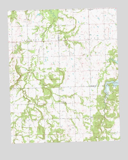
Okfuskee, OK USGS Topographic Map
Click on map above to begin viewing in our Map Viewer.

This topographic map contains these locations and features:
Feature Name Type Latitude Longitude GNIS ID View Map
Brier CreekStreamN35.5570°W96.1769°1090494View Map
Cow CreekStreamN35.5493°W96.2353°1091769View Map
Durant ChurchChurchN35.5515°W96.1594°1092310View Map
Nuyaka CemeteryCemeteryN35.5375°W96.1869°2710151View Map
Nuyaka Mission ChurchChurchN35.5370°W96.1864°1096076View Map
OkfuskeePopulated PlaceN35.5954°W96.2283°1100689View Map
Okfuskee CemeteryCemeteryN35.6018°W96.2203°1096202View Map
Okfuskee Tributaries Site N-1 DamDamN35.6018°W96.1736°1752169View Map
Okfuskee Tributaries Site N-1 ReservoirReservoirN35.6001°W96.1763°1752170View Map
Okfuskee Tributaries Site N-10 DamDamN35.5918°W96.2369°1752177View Map
Okfuskee Tributaries Site N-10 ReservoirReservoirN35.5913°W96.2363°1752178View Map
Okfuskee Tributaries Site N-2 DamDamN35.5934°W96.1686°1752171View Map
Okfuskee Tributaries Site N-2 ReservoirReservoirN35.5914°W96.1667°1752172View Map
Okfuskee Tributaries Site N-4 DamDamN35.5768°W96.1819°1752173View Map
Okfuskee Tributaries Site N-4 ReservoirReservoirN35.5751°W96.1831°1752174View Map
Okfuskee Tributaries Site N6 DamDamN35.5001°W96.1953°1754911View Map
Okfuskee Tributaries Site N6 ReservoirReservoirN35.5001°W96.1953°1754912View Map
Oknoname 107033 DamDamN35.6201°W96.2119°1751256View Map
Oknoname 107033 ReservoirReservoirN35.6206°W96.2146°1751257View Map
OrientalPopulated PlaceN35.5365°W96.2289°1100705View Map
Park Wheeler CornerPopulated PlaceN35.6245°W96.1575°1100719View Map
Philadelphia CreekStreamN35.5076°W96.2036°1096595View Map
Pleasant Hill ChurchChurchN35.6218°W96.1753°1096730View Map
Sixshooter CreekStreamN35.5820°W96.2172°1098083View Map
Sunrise Volunteer Fire DepartmentBuildingN35.5347°W96.1584°2657155View Map
Township of LesterCivilN35.5140°W96.1308°1824898View Map
Township of MorseCivilN35.5084°W96.2447°1824897View Map
Wolf CreekStreamN35.5043°W96.1400°1089507View Map
Woodard CornerPopulated PlaceN35.5220°W96.1589°1100949View Map

Note: Coordinates in the location and feature list above are referenced to NAD83 datum.


Copyright (C) 2008-2025 Ryan Niemi / Sunset Dynamics ... All Rights Reserved