TopoQuest Logo
Do you find TopoQuest useful?
Help keep TopoQuest running and adding new maps/features by donating!
Bitcoin:  19c7KJd3qBynnjoSw5npx9KScwjBe4ifkT
Litecoin:  LXs6TkuXGGXo1vDsWCkWVdjQX94eUKd6ui
Home View Maps Find Maps Find Places Resources & Links


Newcastle, Texas Topographic Map

USGS Map Title: Newcastle, TX
USGS Map MRC: 33098B6
DRG (GeoTIFF) Download: o33098b6.tif


Neighboring USGS Topographic Map Quads:


  Olney, TX  
33098C7
 

  True, TX  
33098C6
 

  Loving, TX  
33098C5
 

  Proffitt, TX  
33098B7
 

  Newcastle, TX  
33098B6
 

  Lake Eddleman, TX  
33098B5
 

  Tackett Mountain, TX  
33098A7
 

  South Bend, TX  
33098A6
 

  Graham, TX  
33098A5


Map MRC Location:

N34°
W99°
N34°
W98°
H8 H7 H6 H5 H4 H3 H2 H1
G8 G7 G6 G5 G4 G3 G2 G1
F8 F7 F6 F5 F4 F3 F2 F1
E8 E7 E6 E5 E4 E3 E2 E1
D8 D7 D6 D5 D4 D3 D2 D1
C8 C7 C6 C5 C4 C3 C2 C1
B8 B7 B6 B5 B4 B3 B2 B1
A8 A7 A6 A5 A4 A3 A2 A1
N33°
W99°
N33°
W98°

Newcastle, TX USGS 1:24K Topographic Map Preview:
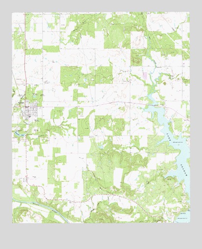
Newcastle, TX USGS Topographic Map
Click on map above to begin viewing in our Map Viewer.

This topographic map contains these locations and features:
Feature Name Type Latitude Longitude GNIS ID View Map
Belknap (historical)Populated PlaceN33.1508°W98.7414°2034575View Map
Belknap CemeteryCemeteryN33.1523°W98.7331°1351818View Map
Belknap Mine Number 1MineN33.1801°W98.7351°1351821View Map
Belknap Mine Number 2MineN33.2015°W98.7356°1351822View Map
Belknap Mine Number 3MineN33.2007°W98.7431°1351823View Map
Belknap Mine Number 4MineN33.1859°W98.7345°1351824View Map
Belknap Mine Number 5MineN33.2007°W98.7306°1351825View Map
Briar CreekStreamN33.2062°W98.6506°1372713View Map
Brier BranchStreamN33.1254°W98.6376°1372718View Map
City of NewcastleCivilN33.1950°W98.7436°2411242View Map
Fort Belknap State ParkParkN33.1509°W98.7409°1357579View Map
Indian Mound CemeteryCemeteryN33.2121°W98.6364°1359968View Map
Johnston LakeReservoirN33.1684°W98.6870°1862015View Map
Johnston Lake DamDamN33.1684°W98.6870°1862014View Map
Little Salt CreekStreamN33.2484°W98.6589°1361458View Map
Mule Pen BranchStreamN33.1259°W98.6359°1375066View Map
NewcastlePopulated PlaceN33.1940°W98.7387°1363841View Map
Newcastle City HallBuildingN33.1941°W98.7391°2753812View Map
Newcastle DamDamN33.1784°W98.7470°1862012View Map
Newcastle LakeReservoirN33.1778°W98.7450°1363842View Map
Newcastle Post OfficePost OfficeN33.1942°W98.7413°2731475View Map
Whiskey Creek DamDamN33.1768°W98.7387°1862010View Map
Whiskey Creek ReservoirReservoirN33.1761°W98.7352°1862011View Map
Wray CemeteryCemeteryN33.1373°W98.7084°1371968View Map
Young CountyCivilN33.1767°W98.6878°1384037View Map
Young County Rural Volunteer Fire Department Station 1BuildingN33.1935°W98.7408°2551297View Map

Note: Coordinates in the location and feature list above are referenced to NAD83 datum.


Copyright (C) 2008-2024 Ryan Niemi / Sunset Dynamics ... All Rights Reserved