TopoQuest Logo
Do you find TopoQuest useful?
Help keep TopoQuest running and adding new maps/features by donating!
Bitcoin:  19c7KJd3qBynnjoSw5npx9KScwjBe4ifkT
Litecoin:  LXs6TkuXGGXo1vDsWCkWVdjQX94eUKd6ui
Home View Maps Find Maps Find Places Resources & Links


Graham, Texas Topographic Map

USGS Map Title: Graham, TX
USGS Map MRC: 33098A5
DRG (GeoTIFF) Download: o33098a5.tif


Neighboring USGS Topographic Map Quads:


  Newcastle, TX  
33098B6
 

  Lake Eddleman, TX  
33098B5
 

  Bryson, TX  
33098B4
 

  South Bend, TX  
33098A6
 

  Graham, TX  
33098A5
 

  Ross Mountain, TX  
33098A4
 

  Ivan North, TX  
32098H6
 

  Cove Creek, TX  
32098H5
 

  Costello Island, TX  
32098H4


Map MRC Location:

N34°
W99°
N34°
W98°
H8 H7 H6 H5 H4 H3 H2 H1
G8 G7 G6 G5 G4 G3 G2 G1
F8 F7 F6 F5 F4 F3 F2 F1
E8 E7 E6 E5 E4 E3 E2 E1
D8 D7 D6 D5 D4 D3 D2 D1
C8 C7 C6 C5 C4 C3 C2 C1
B8 B7 B6 B5 B4 B3 B2 B1
A8 A7 A6 A5 A4 A3 A2 A1
N33°
W99°
N33°
W98°

Graham, TX USGS 1:24K Topographic Map Preview:
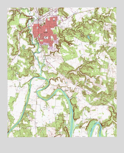
Graham, TX USGS Topographic Map
Click on map above to begin viewing in our Map Viewer.

This topographic map contains these locations and features:
Feature Name Type Latitude Longitude GNIS ID View Map
Bethel Baptist ChurchChurchN33.1121°W98.5795°2024886View Map
Buck HollowValleyN33.1135°W98.5214°1372791View Map
BungerPopulated PlaceN33.0137°W98.5939°1378071View Map
Church of ChristChurchN33.1057°W98.5928°2024891View Map
Church of GodChurchN33.1087°W98.5695°2024894View Map
Church of the NazareneChurchN33.1082°W98.5742°2024836View Map
City of GrahamCivilN33.1017°W98.5778°2410628View Map
Crestview Elementary SchoolSchoolN33.1123°W98.5723°2009228View Map
Dobbs HillSummitN33.1043°W98.6148°1334422View Map
Dry CreekStreamN33.0673°W98.5881°1373471View Map
East Ward Junior High SchoolSchoolN33.1032°W98.5806°1335015View Map
Faith Baptist ChurchChurchN33.1171°W98.5651°2024887View Map
Faith Lutheran ChurchChurchN33.1165°W98.5628°2024838View Map
Farmer CemeteryCemeteryN33.0435°W98.5937°1335708View Map
Farmers BranchStreamN33.1176°W98.5948°1335714View Map
Firemens ParkParkN33.1126°W98.5956°1335809View Map
Flatrock Community CenterLocaleN33.0871°W98.5062°1335939View Map
Flatrock CreekStreamN33.0543°W98.5787°1335941View Map
Gooseneck BendBendN33.0432°W98.5656°1336729View Map
Gooseneck BridgeBridgeN33.0558°W98.5808°1336730View Map
Gooseneck CemeteryCemeteryN33.0282°W98.5814°1336731View Map
Grace Chapel ChurchChurchN33.1123°W98.5684°2024842View Map
GrahamPopulated PlaceN33.1071°W98.5895°1336783View Map
Graham City HallBuildingN33.1072°W98.5915°2753531View Map
Graham Fire and Rescue DepartmentBuildingN33.1024°W98.5850°2552052View Map
Graham High SchoolSchoolN33.0971°W98.5803°2009229View Map
Graham Junior High SchoolSchoolN33.1046°W98.5817°2009230View Map
Graham Learning CenterSchoolN33.1046°W98.5803°2009231View Map
Graham Municipal AirportAirportN33.1122°W98.5586°1386745View Map
Graham Police DepartmentBuildingN33.1167°W98.5844°2750399View Map
Graham Post OfficePost OfficeN33.1154°W98.5803°2731597View Map
Graham Regional Medical CenterHospitalN33.0896°W98.5840°2015660View Map
Haynes MountainSummitN33.0465°W98.5387°1337501View Map
Herron BendBendN33.0110°W98.5220°1337659View Map
Holy Spirit Episcopal ChurchChurchN33.0923°W98.5781°2024837View Map
Lincoln SchoolSchoolN33.1171°W98.5862°1339955View Map
Little Dry CreekStreamN33.1137°W98.5234°1340085View Map
Loving Highway Church of ChristChurchN33.1176°W98.5806°2024893View Map
Manning Vick Dam 1DamN33.0968°W98.5337°1862006View Map
Manning Vick Lake 1ReservoirN33.0964°W98.5322°1862007View Map
Morningside Baptist ChurchChurchN33.1068°W98.5756°2024889View Map
National TheaterBuildingN33.1059°W98.5914°2031807View Map
Newton FieldParkN33.0948°W98.5773°2027711View Map
North Tonk BranchStreamN33.0493°W98.6103°1342820View Map
Oak Grove CemeteryCemeteryN33.1123°W98.5878°1342967View Map
Old Caseyville CrossingPopulated PlaceN33.0129°W98.6139°1378792View Map
Pioneer CemeteryCemeteryN33.1051°W98.5712°1344118View Map
Saint Marys Catholic ChurchChurchN33.0890°W98.5706°2024890View Map
Salem Methodist ChurchChurchN33.0987°W98.5770°2024840View Map
Salt CreekStreamN33.0565°W98.5831°1375931View Map
Shawnee Elementary SchoolSchoolN33.0993°W98.5881°2009237View Map
Shawnee ParkParkN33.0990°W98.5884°1346995View Map
Shawnee SchoolSchoolN33.0979°W98.5887°1346996View Map
South Tonk BranchStreamN33.0493°W98.6101°1347538View Map
Spencer Boyd Street HousesBuildingN33.1057°W98.5856°2032605View Map
Texas Department of Public Safety Highway Patrol OfficeBuildingN33.1146°W98.5899°2750237View Map
Tonk BranchStreamN33.0485°W98.5998°1348639View Map
Twin MountainsPopulated PlaceN33.1096°W98.5828°1348960View Map
Victory ParkParkN33.1082°W98.5867°2030021View Map
Willow BranchStreamN33.1232°W98.6153°1350171View Map
Woodland Elementary SchoolSchoolN33.0932°W98.5687°2009238View Map
Young County JailBuildingN33.1202°W98.5674°2738720View Map
Young County Rural Volunteer Fire Department Station 5BuildingN33.1127°W98.5915°2551299View Map
Young County Sheriff's OfficeBuildingN33.1202°W98.5674°2750371View Map

Note: Coordinates in the location and feature list above are referenced to NAD83 datum.


Copyright (C) 2008-2025 Ryan Niemi / Sunset Dynamics ... All Rights Reserved