TopoQuest Logo
Do you find TopoQuest useful?
Help keep TopoQuest running and adding new maps/features by donating!
Bitcoin:  19c7KJd3qBynnjoSw5npx9KScwjBe4ifkT
Litecoin:  LXs6TkuXGGXo1vDsWCkWVdjQX94eUKd6ui
Home View Maps Find Maps Find Places Resources & Links


Newport, North Carolina Topographic Map

USGS Map Title: Newport, NC
USGS Map MRC: 34076G7
DRG (GeoTIFF) Download: o34076g7.tif


Neighboring USGS Topographic Map Quads:


  Havelock, NC  
34076H8
 

  Cherry Point, NC  
34076H7
 

  Merrimon, NC  
34076H6
 

  Masontown, NC  
34076G8
 

  Newport, NC  
34076G7
 

  Core Creek, NC  
34076G6
 

  Salter Path, NC  
34076F8
 

  Mansfield, NC  
34076F7
 

  Beaufort, NC  
34076F6


Map MRC Location:

N35°
W77°
N35°
W76°
H8 H7 H6 H5 H4 H3 H2 H1
G8 G7 G6 G5 G4 G3 G2 G1
F8 F7 F6 F5 F4 F3 F2 F1
E8 E7 E6 E5 E4 E3 E2 E1
D8 D7 D6 D5 D4 D3 D2 D1
C8 C7 C6 C5 C4 C3 C2 C1
B8 B7 B6 B5 B4 B3 B2 B1
A8 A7 A6 A5 A4 A3 A2 A1
N34°
W77°
N34°
W76°

Newport, NC USGS 1:24K Topographic Map Preview:
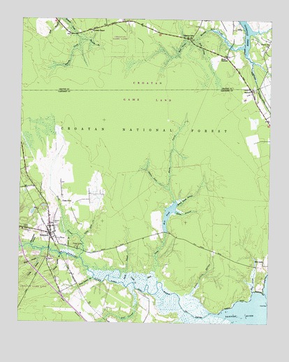
Newport, NC USGS Topographic Map
Click on map above to begin viewing in our Map Viewer.

This topographic map contains these locations and features:
Feature Name Type Latitude Longitude GNIS ID View Map
Billys BranchStreamN34.7960°W76.7972°1009407View Map
Black CreekStreamN34.7660°W76.8102°1009432View Map
Blakes BranchStreamN34.7796°W76.8633°1009466View Map
Body of Christ Holiness ChurchChurchN34.8738°W76.7857°2505907View Map
Britthaven of NewportBuildingN34.8006°W76.8712°2505743View Map
Carteret Correctional CenterBuildingN34.7819°W76.8453°2505314View Map
Cemetery Newport Elementary SchoolSchoolN34.7890°W76.8599°1017486View Map
Craven Cor ChurchChurchN34.8646°W76.7516°1010566View Map
Deep CreekStreamN34.7768°W76.8444°1010724View Map
Dickson ParkParkN34.7779°W76.8666°1017485View Map
Docs Mobile Home ParkPopulated PlaceN34.8174°W76.8719°2505458View Map
East Prong Mortons Mill PondStreamN34.8668°W76.7872°1011003View Map
Ghouls ForkStreamN34.8049°W76.7999°1011473View Map
Harlow Community Chapel ChurchChurchN34.8718°W76.7739°2506150View Map
Harlow Volunteer Fire DepartmentBuildingN34.8589°W76.7716°2638349View Map
HarlowePopulated PlaceN34.8460°W76.7591°1011855View Map
Hull SwampStreamN34.7643°W76.8160°1012274View Map
Hymans ChapelChurchN34.8704°W76.8399°1012322View Map
Laurel BranchStreamN34.7857°W76.8499°1012690View Map
Little Creek SwampStreamN34.7543°W76.7780°1012950View Map
Little Deep CreekStreamN34.7838°W76.8435°1012954View Map
Lodge CreekStreamN34.7660°W76.8166°1013074View Map
Main ProngStreamN34.8010°W76.7977°1013294View Map
Mill CreekStreamN34.7635°W76.7577°1013543View Map
Mill PondReservoirN34.7947°W76.7999°1013565View Map
Mococks BranchStreamN34.8665°W76.8455°1013648View Map
Money Island SwampStreamN34.7990°W76.7963°1013652View Map
Mortons Mill PondStreamN34.8643°W76.7633°1013711View Map
Neusiok TrailTrailN34.8335°W76.7860°1023755View Map
New Hope Missionary Baptist ChurchChurchN34.8602°W76.7539°2506121View Map
NewportPopulated PlaceN34.7865°W76.8591°1013948View Map
Newport CemeteryCemeteryN34.7902°W76.8558°1013949View Map
Newport Elementary SchoolSchoolN34.7863°W76.8584°1017478View Map
Newport Fire DepartmentBuildingN34.7867°W76.8606°2638128View Map
Newport Police DepartmentBuildingN34.7866°W76.8604°2131063View Map
Newport Police DepartmentBuildingN34.7877°W76.8661°2130909View Map
Newport Post OfficePost OfficeN34.7880°W76.8694°2773921View Map
Newport River ParkParkN34.7785°W76.8597°1017484View Map
Newport Town HallBuildingN34.7879°W76.8639°2505989View Map
North HarlowePopulated PlaceN34.8604°W76.7719°1014012View Map
Pilgrims Rest CemeteryCemeteryN34.8677°W76.7905°1017952View Map
Pilgrims Rest ChurchChurchN34.8671°W76.7902°1014398View Map
Sandy BranchStreamN34.7657°W76.8213°1015228View Map
School House BranchStreamN34.7821°W76.8686°1015319View Map
Smiths SwampStreamN34.7768°W76.8641°1015616View Map
Smiths Swamp BranchStreamN34.7777°W76.8538°1015617View Map
Snows Swamp BranchStreamN34.7682°W76.8372°1015655View Map
The NarrowsChannelN34.7532°W76.7860°1016091View Map
Township of NewportCivilN34.7944°W76.8633°1026507View Map
Union PointPopulated PlaceN34.7996°W76.8533°1023043View Map
West Prong Mortons Mill PondStreamN34.8668°W76.7872°1016551View Map

Note: Coordinates in the location and feature list above are referenced to NAD83 datum.


Copyright (C) 2008-2024 Ryan Niemi / Sunset Dynamics ... All Rights Reserved