TopoQuest Logo
Do you find TopoQuest useful?
Help keep TopoQuest running and adding new maps/features by donating!
Bitcoin:  19c7KJd3qBynnjoSw5npx9KScwjBe4ifkT
Litecoin:  LXs6TkuXGGXo1vDsWCkWVdjQX94eUKd6ui
Home View Maps Find Maps Find Places Resources & Links


Core Creek, North Carolina Topographic Map

USGS Map Title: Core Creek, NC
USGS Map MRC: 34076G6
DRG (GeoTIFF) Download: o34076g6.tif


Neighboring USGS Topographic Map Quads:


  Cherry Point, NC  
34076H7
 

  Merrimon, NC  
34076H6
 

  South River, NC  
34076H5
 

  Newport, NC  
34076G7
 

  Core Creek, NC  
34076G6
 

  Williston, NC  
34076G5
 

  Mansfield, NC  
34076F7
 

  Beaufort, NC  
34076F6
 

  Harkers Island, NC  
34076F5


Map MRC Location:

N35°
W77°
N35°
W76°
H8 H7 H6 H5 H4 H3 H2 H1
G8 G7 G6 G5 G4 G3 G2 G1
F8 F7 F6 F5 F4 F3 F2 F1
E8 E7 E6 E5 E4 E3 E2 E1
D8 D7 D6 D5 D4 D3 D2 D1
C8 C7 C6 C5 C4 C3 C2 C1
B8 B7 B6 B5 B4 B3 B2 B1
A8 A7 A6 A5 A4 A3 A2 A1
N34°
W77°
N34°
W76°

Core Creek, NC USGS 1:24K Topographic Map Preview:
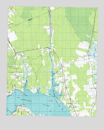
Core Creek, NC USGS Topographic Map
Click on map above to begin viewing in our Map Viewer.

This topographic map contains these locations and features:
Feature Name Type Latitude Longitude GNIS ID View Map
Adams Creek CanalCanalN34.8446°W76.6899°980041View Map
Alligator CreekStreamN34.7924°W76.7230°1008688View Map
Barge Landing BasinLocaleN34.8235°W76.6905°1017959View Map
Bayview ChurchChurchN34.7810°W76.7372°1008967View Map
Bell CreekBayN34.7868°W76.6819°1009162View Map
Big CreekStreamN34.7782°W76.7391°1009298View Map
Cedarville EstatesPopulated PlaceN34.7513°W76.6374°1017491View Map
Core CreekPopulated PlaceN34.8285°W76.6930°1019784View Map
Core CreekBayN34.7774°W76.6858°1010484View Map
Crab Point VillagePopulated PlaceN34.7604°W76.7302°1019833View Map
Craven CornerPopulated PlaceN34.8668°W76.7499°1017419View Map
Cross RockBarN34.7563°W76.7485°1010593View Map
Dead Cow FieldAirportN34.7577°W76.6466°2717304View Map
Deer Field ShoresBeachN34.7579°W76.6627°1017494View Map
Eastman CreekStreamN34.7974°W76.6858°1011008View Map
Feltons CreekStreamN34.8210°W76.6310°1011196View Map
Freewill ChurchChurchN34.7613°W76.6566°1011389View Map
Graham ChapelChurchN34.7935°W76.7385°1011592View Map
Harlowe CanalCanalN34.8363°W76.7494°1011856View Map
Harlowe ChurchChurchN34.8227°W76.7333°1011857View Map
Harlowe CreekStreamN34.7768°W76.7199°1011858View Map
Joslyn TracePopulated PlaceN34.7521°W76.7194°1017474View Map
Lawton PointCapeN34.7613°W76.7338°1012759View Map
Little CreekStreamN34.7804°W76.7358°1012934View Map
Live Oak Grove ChurchChurchN34.7643°W76.6591°1013050View Map
McDanielsPopulated PlaceN34.7538°W76.6502°1017493View Map
Mill CreekPopulated PlaceN34.7760°W76.7472°1021452View Map
Mill Creek Fire and Rescue DepartmentBuildingN34.7750°W76.7487°2638930View Map
Mount Tabor Missionary Baptist ChurchChurchN34.8101°W76.6321°2505708View Map
North HarborPopulated PlaceN34.7604°W76.6330°1017492View Map
North RiverPopulated PlaceN34.8166°W76.6358°1014023View Map
North River and Laurel Road Volunteer Fire DepartmentBuildingN34.8097°W76.6332°2638230View Map
North River CornerPopulated PlaceN34.7827°W76.6263°1014025View Map
North River United Methodist ChurchChurchN34.7549°W76.6314°2506193View Map
Oyster CreekBayN34.7788°W76.7055°1014166View Map
Penn PointCapeN34.7624°W76.7260°1014322View Map
River HeightsPopulated PlaceN34.7527°W76.7172°1017475View Map
Russell CreekStreamN34.7588°W76.6638°1015138View Map
SeagatePopulated PlaceN34.8474°W76.6885°1947859View Map
Tattles Grove ChurchChurchN34.7888°W76.6688°1016041View Map
Township of BeaufortCivilN34.7915°W76.6493°1026499View Map
Township of HarloweCivilN34.8119°W76.7268°1026503View Map
Turtle RockBarN34.7707°W76.7347°1016291View Map
Ware CreekBayN34.7757°W76.6733°1016442View Map
White RockBarN34.7732°W76.7235°1016600View Map

Note: Coordinates in the location and feature list above are referenced to NAD83 datum.


Copyright (C) 2008-2024 Ryan Niemi / Sunset Dynamics ... All Rights Reserved