TopoQuest Logo
Do you find TopoQuest useful?
Help keep TopoQuest running and adding new maps/features by donating!
Bitcoin:  19c7KJd3qBynnjoSw5npx9KScwjBe4ifkT
Litecoin:  LXs6TkuXGGXo1vDsWCkWVdjQX94eUKd6ui
Home View Maps Find Maps Find Places Resources & Links


Newport, New York Topographic Map

USGS Map Title: Newport, NY
USGS Map MRC: 43075B1
DRG (GeoTIFF) Download: o43075b1.tif


Neighboring USGS Topographic Map Quads:


  Remsen, NY  
43075C2
 

  Hinckley, NY  
43075C1


  South Trenton, NY  
43075B2
 

  Newport, NY  
43075B1
 

  Middleville, NY  
43074B8
 

  Utica East, NY  
43075A2
 

  Ilion, NY  
43075A1
 

  Herkimer, NY  
43074A8


Map MRC Location:

N44°
W76°
N44°
W75°
H8 H7 H6 H5 H4 H3 H2 H1
G8 G7 G6 G5 G4 G3 G2 G1
F8 F7 F6 F5 F4 F3 F2 F1
E8 E7 E6 E5 E4 E3 E2 E1
D8 D7 D6 D5 D4 D3 D2 D1
C8 C7 C6 C5 C4 C3 C2 C1
B8 B7 B6 B5 B4 B3 B2 B1
A8 A7 A6 A5 A4 A3 A2 A1
N43°
W76°
N43°
W75°

Newport, NY USGS 1:24K Topographic Map Preview:
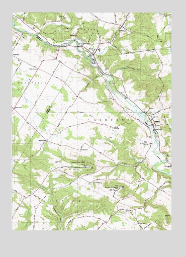
Newport, NY USGS Topographic Map
Click on map above to begin viewing in our Map Viewer.

This topographic map contains these locations and features:
Feature Name Type Latitude Longitude GNIS ID View Map
Bell HillSummitN43.1620°W75.1163°943587View Map
Blue Anchor Park Mobile Home ParkPopulated PlaceN43.2313°W75.0790°2598763View Map
Brayton CornersPopulated PlaceN43.2017°W75.0736°2123440View Map
Bromley SchoolSchoolN43.2290°W75.0132°944813View Map
Brown IslandIslandN43.1803°W75.0118°944918View Map
Buck HillSummitN43.2370°W75.0585°945020View Map
Bullard SchoolSchoolN43.1495°W75.0099°945138View Map
Carey CornersLocaleN43.1365°W75.0318°945825View Map
Circle T FarmsLocaleN43.1364°W75.1039°2557042View Map
Cold BrookPopulated PlaceN43.2417°W75.0388°947025View Map
Cold BrookStreamN43.2240°W75.0629°947036View Map
Cold Brook CemeteryCemeteryN43.2477°W75.0374°2556832View Map
Cold Brook Post OfficePost OfficeN43.2431°W75.0379°2598751View Map
Community Baptist ChurchChurchN43.2235°W75.0593°2597768View Map
Dempsey SchoolSchoolN43.1276°W75.0515°948293View Map
Dewey CornersLocaleN43.1948°W75.1232°948379View Map
Farrel CornerPopulated PlaceN43.1712°W75.0715°972462View Map
First Baptist ChurchChurchN43.1884°W75.0169°2597769View Map
Harter HillSummitN43.1326°W75.0060°952303View Map
Irish SettlementPopulated PlaceN43.1523°W75.0635°972653View Map
Kuyahoora FarmLocaleN43.1808°W75.0078°2557044View Map
Kuyahoora Valley Ambulance CorpsBuildingN43.2252°W75.0643°2720116View Map
Martin CornersLocaleN43.1767°W75.0971°956582View Map
Martins Corners CemeteryCemeteryN43.1762°W75.0968°2556837View Map
Mill CreekStreamN43.2445°W75.1229°957235View Map
NewportPopulated PlaceN43.1859°W75.0143°958518View Map
Newport CemeteryCemeteryN43.1887°W75.0186°2556835View Map
Newport Methodist ChurchChurchN43.1882°W75.0155°2597777View Map
Newport Post OfficePost OfficeN43.1858°W75.0152°2598759View Map
Newport Volunteer Fire DepartmentBuildingN43.1822°W75.0114°2718479View Map
Oklahoma GulfValleyN43.2137°W75.0471°959244View Map
Pine Grove CemeteryCemeteryN43.2168°W75.0534°960449View Map
PolandPopulated PlaceN43.2256°W75.0613°960850View Map
Poland CemeteryCemeteryN43.2242°W75.0583°2556834View Map
Poland Elementary SchoolSchoolN43.2282°W75.0568°2597753View Map
Poland Junior - Senior High SchoolSchoolN43.2288°W75.0569°2597763View Map
Poland Post OfficePost OfficeN43.2268°W75.0596°2598760View Map
Poland Public LibraryBuildingN43.2262°W75.0621°2598803View Map
Poland Volunteer Fire DepartmentBuildingN43.2260°W75.0625°2718566View Map
Poplar Tree SchoolSchoolN43.2173°W75.0910°960947View Map
Rose ValleyValleyN43.1915°W75.0171°962913View Map
Saint Johns CemeteryCemeteryN43.1787°W75.0134°963615View Map
Saint Patrick's CemeteryCemeteryN43.1521°W75.0635°2556841View Map
School Number 3 (historical)SchoolN43.2017°W75.0729°975283View Map
School Number 8 (historical)SchoolN43.1456°W75.1060°975602View Map
Schrader HillSummitN43.1284°W75.0132°964615View Map
Shed BrookStreamN43.1692°W75.0104°964987View Map
Smoky HollowValleyN43.1670°W75.0190°965540View Map
Swezey Hill CemeteryCemeteryN43.2282°W75.0129°944812View Map
Tanner HillSummitN43.1615°W75.0652°967040View Map
Tanner Hill CemeteryCemeteryN43.1642°W75.0912°967041View Map
The Golf Club of NewportLocaleN43.1809°W75.0461°2598795View Map
Town of NewportCivilN43.1779°W75.0364°979270View Map
Union ChurchChurchN43.2228°W75.1199°968181View Map
Village of Cold BrookCivilN43.2399°W75.0389°2391618View Map
Village of NewportCivilN43.1859°W75.0151°2391017View Map
Village of PolandCivilN43.2260°W75.0613°2391071View Map
Walker CornersLocaleN43.2178°W75.1043°968681View Map
Welch Calvinistic Methodist CemeteryCemeteryN43.1725°W75.0767°2556840View Map
West Canada Valley Elementary SchoolSchoolN43.1620°W75.0005°2597755View Map
White CreekStreamN43.1648°W75.0060°971096View Map

Note: Coordinates in the location and feature list above are referenced to NAD83 datum.


Copyright (C) 2008-2024 Ryan Niemi / Sunset Dynamics ... All Rights Reserved