TopoQuest Logo
Do you find TopoQuest useful?
Help keep TopoQuest running and adding new maps/features by donating!
Bitcoin:  19c7KJd3qBynnjoSw5npx9KScwjBe4ifkT
Litecoin:  LXs6TkuXGGXo1vDsWCkWVdjQX94eUKd6ui
Home View Maps Find Maps Find Places Resources & Links


Middleville, New York Topographic Map

USGS Map Title: Middleville, NY
USGS Map MRC: 43074B8
DRG (GeoTIFF) Download: o43074b8.tif


Neighboring USGS Topographic Map Quads:


  Hinckley, NY  
43075C1


  Newport, NY  
43075B1
 

  Middleville, NY  
43074B8
 

  Salisbury, NY  
43074B7
 

  Ilion, NY  
43075A1
 

  Herkimer, NY  
43074A8
 

  Little Falls, NY  
43074A7


Map MRC Location:

N44°
W75°
N44°
W74°
H8 H7 H6 H5 H4 H3 H2 H1
G8 G7 G6 G5 G4 G3 G2 G1
F8 F7 F6 F5 F4 F3 F2 F1
E8 E7 E6 E5 E4 E3 E2 E1
D8 D7 D6 D5 D4 D3 D2 D1
C8 C7 C6 C5 C4 C3 C2 C1
B8 B7 B6 B5 B4 B3 B2 B1
A8 A7 A6 A5 A4 A3 A2 A1
N43°
W75°
N43°
W74°

Middleville, NY USGS 1:24K Topographic Map Preview:
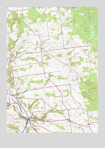
Middleville, NY USGS Topographic Map
Click on map above to begin viewing in our Map Viewer.

This topographic map contains these locations and features:
Feature Name Type Latitude Longitude GNIS ID View Map
Barto HillSummitN43.1306°W74.8896°943108View Map
Big Bill BrookStreamN43.1995°W74.9885°943841View Map
Black Creek SchoolSchoolN43.2387°W74.9268°944130View Map
City BrookStreamN43.1615°W74.9929°971555View Map
Dairy HillSummitN43.1912°W74.8971°947989View Map
Dairy Hill SchoolSchoolN43.2073°W74.8885°947990View Map
Elm Tree CemeteryCemeteryN43.1805°W74.9839°2556847View Map
Factory BrookStreamN43.1965°W74.9938°949794View Map
FairfieldPopulated PlaceN43.1373°W74.9132°949809View Map
Fairfield Cemetery EastCemeteryN43.1357°W74.9112°2556846View Map
Fairfield Cemetery WestCemeteryN43.1384°W74.9159°2556845View Map
Hardscrabble CemeteryCemeteryN43.1609°W74.9239°952209View Map
Huckleberry SwampSwampN43.2245°W74.8852°953378View Map
HurricanePopulated PlaceN43.2470°W74.9782°953527View Map
Hurricane BrookStreamN43.1965°W74.9938°953528View Map
Maltanner CreekStreamN43.1384°W74.9710°956324View Map
MiddlevillePopulated PlaceN43.1387°W74.9682°957158View Map
Middleville Fire Department E W Corey Hose CompanyBuildingN43.1409°W74.9708°2718366View Map
Middleville Post OfficePost OfficeN43.1389°W74.9690°2598757View Map
Middleville Rest HomeBuildingN43.1398°W74.9702°2599643View Map
Middleville Rural CemeteryCemeteryN43.1386°W74.9661°2556844View Map
NorwayPopulated PlaceN43.2084°W74.9521°959018View Map
Norway Rural CemeteryCemeteryN43.2106°W74.9533°2556842View Map
Old CityPopulated PlaceN43.1628°W74.9849°959265View Map
Route 28 CemeteryCemeteryN43.1478°W74.9755°2556843View Map
School Number 2 (historical)SchoolN43.1342°W74.9678°2123436View Map
School Number 7 (historical)SchoolN43.1331°W74.8874°975561View Map
Sweet CemeteryCemeteryN43.1988°W74.8873°966913View Map
Town of FairfieldCivilN43.1270°W74.9220°978950View Map
Town of NorwayCivilN43.2217°W74.9447°979295View Map
Village of MiddlevilleCivilN43.1384°W74.9708°2390981View Map
Welch CornersLocaleN43.1595°W74.9868°969021View Map
West Canada Creek BridgeBridgeN43.1382°W74.9702°2598780View Map
West Canada Valley Junior - Senior High SchoolSchoolN43.1626°W74.9994°2597764View Map
Woodchuck HillSummitN43.1831°W74.9993°971620View Map

Note: Coordinates in the location and feature list above are referenced to NAD83 datum.


Copyright (C) 2008-2025 Ryan Niemi / Sunset Dynamics ... All Rights Reserved