TopoQuest Logo
Do you find TopoQuest useful?
Help keep TopoQuest running and adding new maps/features by donating!
Bitcoin:  19c7KJd3qBynnjoSw5npx9KScwjBe4ifkT
Litecoin:  LXs6TkuXGGXo1vDsWCkWVdjQX94eUKd6ui
Home View Maps Find Maps Find Places Resources & Links


Newport South, Oregon Topographic Map

USGS Map Title: Newport South, OR
USGS Map MRC: 44124E1
DRG (GeoTIFF) Download: o44124e1.tif


Neighboring USGS Topographic Map Quads:


  Newport North, OR  
44124F1
 

  Toledo North, OR  
44123F8


  Newport South, OR  
44124E1
 

  Toledo South, OR  
44123E8


  Waldport, OR  
44124D1
 

  Tidewater, OR  
44123D8


Map MRC Location:

N45°
W125°
N45°
W124°
H8 H7 H6 H5 H4 H3 H2 H1
G8 G7 G6 G5 G4 G3 G2 G1
F8 F7 F6 F5 F4 F3 F2 F1
E8 E7 E6 E5 E4 E3 E2 E1
D8 D7 D6 D5 D4 D3 D2 D1
C8 C7 C6 C5 C4 C3 C2 C1
B8 B7 B6 B5 B4 B3 B2 B1
A8 A7 A6 A5 A4 A3 A2 A1
N44°
W125°
N44°
W124°

Newport South, OR USGS 1:24K Topographic Map Preview:
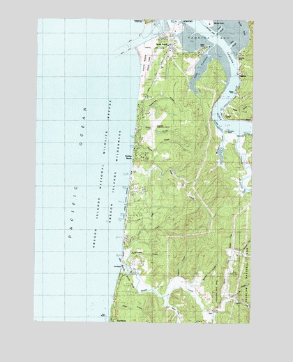
Newport South, OR USGS Topographic Map
Click on map above to begin viewing in our Map Viewer.

This topographic map contains these locations and features:
Feature Name Type Latitude Longitude GNIS ID View Map
Bay Hills ReservoirReservoirN44.6102°W124.0058°1154762View Map
Beaver CreekStreamN44.5235°W124.0762°1137805View Map
Bowers CreekStreamN44.5251°W124.0123°1154768View Map
Bunnel CreekStreamN44.5148°W124.0385°1637932View Map
Center SloughGutN44.6210°W124.0207°1135126View Map
City of NewportCivilN44.6230°W124.0524°2411248View Map
Coquille PointCapeN44.6093°W124.0101°1140115View Map
Deer CreekStreamN44.5079°W124.0810°1140829View Map
Elkhorn CreekStreamN44.5098°W124.0115°1141815View Map
ForfarPopulated PlaceN44.5526°W124.0679°1154765View Map
Grant CreekStreamN44.5807°W124.0693°1142942View Map
Hatfield Marine Science Center - Oregon State UniversitySchoolN44.6224°W124.0456°1162305View Map
Henderson CreekStreamN44.5893°W124.0687°1143487View Map
Holiday BeachPopulated PlaceN44.5676°W124.0682°1143664View Map
Idaho PointCapeN44.6137°W124.0276°1143616View Map
Idaho Point MarinaHarborN44.6140°W124.0267°2668400View Map
Idaho Point Marina Boat RampLocaleN44.6137°W124.0265°2668318View Map
King SloughStreamN44.6123°W124.0246°1144614View Map
Lincoln GrangeLocaleN44.5054°W124.0240°1145033View Map
Lost CreekStreamN44.5440°W124.0737°1145514View Map
Lost Creek State Recreation SiteParkN44.5457°W124.0732°1145530View Map
McCaffery SloughStreamN44.5796°W124.0179°1145914View Map
McCaffrey IslandIslandN44.5790°W124.0165°1135130View Map
Mike Miller County ParkParkN44.6037°W124.0523°2022205View Map
Moore CreekStreamN44.5721°W124.0698°1146432View Map
Newport Fire Department Station 10BuildingN44.5869°W124.0631°2576644View Map
Newport Municipal AirportAirportN44.5783°W124.0619°1154018View Map
Newport Wastewater Treatment PlantLocaleN44.5971°W124.0479°2660708View Map
North Fork Beaver CreekStreamN44.5098°W124.0129°1146906View Map
North Fork Elkhorn CreekStreamN44.5107°W124.0096°1135131View Map
North JettyDamN44.6171°W124.0679°1147031View Map
OnaPopulated PlaceN44.5040°W124.0223°1147221View Map
Ona BeachBeachN44.5262°W124.0762°1154766View Map
Ona Beach State ParkParkN44.5185°W124.0726°1154767View Map
Ona Beach State Park Boat RampLocaleN44.5204°W124.0696°2668180View Map
Ona Post Office (historical)Post OfficeN44.5040°W124.0223°1165739View Map
Oneatta PointCapeN44.5862°W124.0176°1147224View Map
Oneatta Post Office (historical)Post OfficeN44.5862°W124.0176°1164563View Map
Oregon Coast Community College LibraryBuildingN44.6098°W124.0511°2661641View Map
Oregon Coast Community College LibraryBuildingN44.6098°W124.0511°2661466View Map
Oregon Islands WildernessReserveN44.5070°W124.1217°1947419View Map
OystervillePopulated PlaceN44.5779°W124.0021°1147326View Map
Parker SloughStreamN44.5904°W124.0154°1147457View Map
Peterson CreekStreamN44.5293°W124.0054°1147613View Map
Poole SloughStreamN44.5776°W124.0096°1147883View Map
Port of Newport Marina and RV ParkHarborN44.6223°W124.0521°2668412View Map
Port of Newport Marina and RV Park Boat Ramp NorthLocaleN44.6228°W124.0508°2668441View Map
Port of Newport Marina and RV Park Boat Ramp SouthLocaleN44.6205°W124.0501°2668384View Map
Pumphouse CreekStreamN44.5285°W124.0729°1148042View Map
Sallys BendBendN44.6207°W124.0123°1135132View Map
Sallys SloughGutN44.6151°W124.0132°1135127View Map
Sawyers LandingHarborN44.6032°W124.0104°2668101View Map
Sawyers Landing Boat LaunchLocaleN44.6027°W124.0103°2668169View Map
Seal Rock County WaysideParkN44.5087°W124.0812°2022206View Map
Seal RocksIslandN44.5046°W124.0840°1149194View Map
Simpson CreekStreamN44.5140°W124.0462°1159202View Map
South BeachPopulated PlaceN44.6126°W124.0487°1150095View Map
South Beach Post OfficePost OfficeN44.6126°W124.0487°1165964View Map
South Beach State ParkParkN44.6040°W124.0637°1154763View Map
South Beaver CreekStreamN44.5110°W124.0482°1149901View Map
South JettyDamN44.6146°W124.0648°1150050View Map
South ReefBarN44.6029°W124.0885°1135959View Map
The BendBendN44.5826°W124.0235°1135129View Map
Thiel CreekStreamN44.5646°W124.0715°1151051View Map
Tracy CreekStreamN44.5210°W124.0687°1151359View Map
United States Coast Guard Air Facility NewportBuildingN44.5770°W124.0633°2661177View Map
United States Coast Guard Motor Lifeboat Station Yaquina BayBuildingN44.6246°W124.0589°2512147View Map
Weiser PointCapeN44.5951°W124.0118°1135128View Map
WinantLocaleN44.5835°W124.0023°1152469View Map
Winant Post Office (historical)Post OfficeN44.5835°W124.0023°1166194View Map
Worth CreekStreamN44.5026°W124.0226°1154760View Map
YaquinaPopulated PlaceN44.6021°W124.0087°1152697View Map
Yaquina BayBayN44.6204°W124.0382°1152698View Map
Yaquina Bay LighthouseBuildingN44.6242°W124.0629°2661175View Map
Yaquina Bay State Recreation SiteParkN44.6237°W124.0632°1152699View Map
Yaquina Post Office (historical)Post OfficeN44.6021°W124.0087°1166223View Map
Yaquina ReefBarN44.6196°W124.0879°1135958View Map
Yaquina RiverStreamN44.6123°W124.0179°1152700View Map

Note: Coordinates in the location and feature list above are referenced to NAD83 datum.


Copyright (C) 2008-2024 Ryan Niemi / Sunset Dynamics ... All Rights Reserved