TopoQuest Logo
Do you find TopoQuest useful?
Help keep TopoQuest running and adding new maps/features by donating!
Bitcoin:  19c7KJd3qBynnjoSw5npx9KScwjBe4ifkT
Litecoin:  LXs6TkuXGGXo1vDsWCkWVdjQX94eUKd6ui
Home View Maps Find Maps Find Places Resources & Links


Niemackl Lakes, Minnesota Topographic Map

USGS Map Title: Niemackl Lakes, MN
USGS Map MRC: 45096G1
DRG (GeoTIFF) Download: o45096g1.tif


Neighboring USGS Topographic Map Quads:


  Herman NW, MN  
45096H2
 

  Trisko Lake, MN  
45096H1
 

  Elbow Lake, MN  
45095H8
 

  Herman, MN  
45096G2
 

  Niemackl Lakes, MN  
45096G1
 

  Patchen Lake, MN  
45095G8
 

  Chokio NW, MN  
45096F2
 

  Donnelly, MN  
45096F1
 

  Wintermute Lake, MN  
45095F8


Map MRC Location:

N46°
W97°
N46°
W96°
H8 H7 H6 H5 H4 H3 H2 H1
G8 G7 G6 G5 G4 G3 G2 G1
F8 F7 F6 F5 F4 F3 F2 F1
E8 E7 E6 E5 E4 E3 E2 E1
D8 D7 D6 D5 D4 D3 D2 D1
C8 C7 C6 C5 C4 C3 C2 C1
B8 B7 B6 B5 B4 B3 B2 B1
A8 A7 A6 A5 A4 A3 A2 A1
N45°
W97°
N45°
W96°

Niemackl Lakes, MN USGS 1:24K Topographic Map Preview:
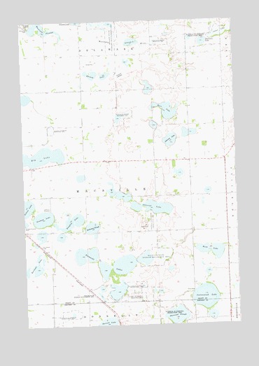
Niemackl Lakes, MN USGS Topographic Map
Click on map above to begin viewing in our Map Viewer.

This topographic map contains these locations and features:
Feature Name Type Latitude Longitude GNIS ID View Map
Barrows LakeLakeN45.7753°W96.1190°639650View Map
Big LakeLakeN45.8198°W96.1131°640097View Map
Burr LakeLakeN45.8381°W96.0395°640676View Map
Cottonwood LakeLakeN45.7611°W96.0198°641535View Map
Doughty LakeLakeN45.7930°W96.0981°642904View Map
Graham LakeLakeN45.7943°W96.1138°644315View Map
Hazzard LakebedFlatN45.8530°W96.0664°644814View Map
Helsene State Wildlife Management AreaParkN45.8730°W96.0720°644856View Map
Hibrooten LakeLakeN45.8661°W96.0174°644927View Map
Johnson LakeLakeN45.8258°W96.0381°645688View Map
Jones LakeSwampN45.8708°W96.0012°645732View Map
Keitzman SloughLakeN45.7903°W96.0853°646063View Map
Lakeside CemeteryCemeteryN45.7986°W96.1114°2068480View Map
Lakeside CemeteryCemeteryN45.7986°W96.1114°646418View Map
Macsville State Wildlife Management AreaParkN45.7769°W96.0484°647356View Map
Moose Island (historical)LocaleN45.7556°W96.0764°2066956View Map
Moose Island Post Office (historical)Post OfficeN45.7556°W96.0764°2066957View Map
Mustinka DamDamN45.8722°W96.1198°648405View Map
Mustinka FlowageReservoirN45.8725°W96.1130°648406View Map
Mustinka River DamDamN45.8733°W96.1220°1775918View Map
Mustinka River ReservoirReservoirN45.8733°W96.1220°1775919View Map
Nelson LakeLakeN45.7987°W96.1243°648466View Map
Niemackl Lake Park CampgroundLocaleN45.7667°W96.0750°2068428View Map
Niemackl LakesLakeN45.7722°W96.0726°648552View Map
Ohlsrud LakeLakeN45.7983°W96.0493°648907View Map
Pine Ridge ParkParkN45.8741°W96.1178°649493View Map
Rhimey LakeLakeN45.8525°W96.0841°649957View Map
Saint Charles CemeteryCemeteryN45.7833°W96.1147°2068479View Map
Saint Charles CemeteryCemeteryN45.7830°W96.1150°650551View Map
School Number 19 (historical)SchoolN45.8686°W96.1108°2110053View Map
School Number 21 (historical)SchoolN45.7881°W96.0478°2110055View Map
School Number 58 (historical)SchoolN45.8686°W96.0483°2110054View Map
School Number 62 (historical)SchoolN45.7844°W96.1222°2110056View Map
Schram LakeLakeN45.8664°W96.0599°651781View Map
Sherstad SloughLakeN45.7539°W96.0376°651969View Map
Towner State Wildlife Management AreaParkN45.7611°W96.0917°2068427View Map
Township of MacsvilleCivilN45.8031°W96.0682°664866View Map
Werk LakeLakeN45.7802°W96.0155°653915View Map
Wilts State Wildlife Management AreaParkN45.8358°W96.0673°654241View Map

Note: Coordinates in the location and feature list above are referenced to NAD83 datum.


Copyright (C) 2008-2025 Ryan Niemi / Sunset Dynamics ... All Rights Reserved