TopoQuest Logo
Do you find TopoQuest useful?
Help keep TopoQuest running and adding new maps/features by donating!
Bitcoin:  19c7KJd3qBynnjoSw5npx9KScwjBe4ifkT
Litecoin:  LXs6TkuXGGXo1vDsWCkWVdjQX94eUKd6ui
Home View Maps Find Maps Find Places Resources & Links


Elbow Lake, Minnesota Topographic Map

USGS Map Title: Elbow Lake, MN
USGS Map MRC: 45095H8
DRG (GeoTIFF) Download: o45095h8.tif


Neighboring USGS Topographic Map Quads:


  Wendell, MN  
46096A1
 

  Fourmile Lake, MN  
46095A8
 

  Ashby, MN  
46095A7
 

  Trisko Lake, MN  
45096H1
 

  Elbow Lake, MN  
45095H8
 

  Erdahl, MN  
45095H7
 

  Niemackl Lakes, MN  
45096G1
 

  Patchen Lake, MN  
45095G8
 

  Hoffman, MN  
45095G7


Map MRC Location:

N46°
W96°
N46°
W95°
H8 H7 H6 H5 H4 H3 H2 H1
G8 G7 G6 G5 G4 G3 G2 G1
F8 F7 F6 F5 F4 F3 F2 F1
E8 E7 E6 E5 E4 E3 E2 E1
D8 D7 D6 D5 D4 D3 D2 D1
C8 C7 C6 C5 C4 C3 C2 C1
B8 B7 B6 B5 B4 B3 B2 B1
A8 A7 A6 A5 A4 A3 A2 A1
N45°
W96°
N45°
W95°

Elbow Lake, MN USGS 1:24K Topographic Map Preview:
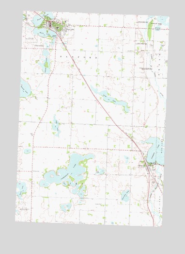
Elbow Lake, MN USGS Topographic Map
Click on map above to begin viewing in our Map Viewer.

This topographic map contains these locations and features:
Feature Name Type Latitude Longitude GNIS ID View Map
BarrettLocaleN45.9106°W95.8875°2068452View Map
BarrettPopulated PlaceN45.9105°W95.8903°639644View Map
Barrett Fire DepartmentBuildingN45.9093°W95.8898°2666285View Map
Barrett LakeReservoirN45.9122°W95.8828°639647View Map
Barrett Lake Resort and CampgroundLocaleN45.9117°W95.8847°2068453View Map
Barrett Post OfficePost OfficeN45.9111°W95.8900°2068455View Map
Bethania CemeteryCemeteryN45.9052°W95.9870°639985View Map
Bethesda CemeteryCemeteryN45.9192°W95.9011°2068485View Map
Blakesley Slough DamDamN45.9683°W95.8937°1777038View Map
Christ Lutheran ChurchChurchN45.9933°W95.9228°2068438View Map
City of BarrettCivilN45.9124°W95.8944°2394069View Map
City of Elbow LakeCivilN45.9905°W95.9777°2394636View Map
Cormorant LakeLakeN45.9054°W95.9557°641504View Map
Eide LakeLakeN45.9321°W95.9684°643204View Map
Elbow LakeLocaleN45.9906°W95.9756°2068435View Map
Elbow LakePopulated PlaceN45.9941°W95.9767°643230View Map
Elbow Lake Fire DepartmentBuildingN45.9926°W95.9750°2666326View Map
Elbow Lake LibraryBuildingN45.9939°W95.9761°2068430View Map
Elbow Lake Municipal Airport - Pride of the PrairieAirportN45.9873°W95.9921°660137View Map
Elbow Lake Police DepartmentBuildingN45.9924°W95.9748°2068431View Map
Elbow Lake Post OfficePost OfficeN45.9914°W95.9750°2068434View Map
First Presbyterian ChurchChurchN45.9922°W95.9722°2068439View Map
Flekkefjord LakeLakeN45.9868°W95.9805°654389View Map
Fridhem CemeteryCemeteryN45.8755°W95.9459°643951View Map
Grace Evangelical Free ChurchChurchN45.9889°W95.9631°2068440View Map
Grant ClinicHospitalN45.9922°W95.9758°2068446View Map
Grant County Historical MuseumBuildingN45.9950°W95.9756°2068432View Map
Grant County Sheriff's OfficeBuildingN45.9949°W95.9768°2068433View Map
Horseshoe LakeLakeN45.8925°W95.9074°645219View Map
Huset LakeLakeN45.8944°W95.9964°645313View Map
Immanuel ChurchChurchN45.8869°W95.9284°645378View Map
Immanuel Lutheran CemeteryCemeteryN45.8872°W95.9305°2068483View Map
Island LakeLakeN45.9658°W95.9803°645477View Map
Kenney LakeLakeN45.9931°W95.8848°646098View Map
Lakeview Assembly of God ChurchChurchN45.9956°W95.9661°2068441View Map
Long LakeLakeN45.9496°W95.9226°647070View Map
Lund CemeteryCemeteryN45.9272°W95.9875°647290View Map
Native American Burial GroundsCemeteryN45.9167°W95.9000°2068484View Map
Ness CemeteryCemeteryN45.9975°W95.9967°648486View Map
North Elementary SchoolSchoolN45.9906°W95.9694°2068447View Map
Peace Lutheran ChurchChurchN45.9119°W95.8869°2068456View Map
Pomme de Terre State Wildlife Management AreaParkN45.9969°W95.8920°649623View Map
Prairie Ridge Hospital and Health ServicesHospitalN45.9944°W95.9639°2068445View Map
Saint Loretto Catholic CemeteryCemeteryN45.9972°W95.9944°2068474View Map
Saint Olaf Catholic ChurchChurchN45.9925°W95.9689°2068442View Map
School Number 25 (historical)SchoolN45.9200°W95.9869°2111065View Map
School Number 48 (historical)SchoolN45.9625°W95.9186°2111063View Map
School Number 53 (historical)SchoolN45.9044°W95.9247°2111066View Map
School Number 60 (historical)SchoolN45.9344°W95.9561°2111064View Map
Storm-bordson State Wildlife Management AreaParkN45.9836°W95.8906°652703View Map
Swan LakeLakeN45.9066°W95.9284°652895View Map
Thorsborg (historical)Populated PlaceN45.9778°W95.9039°2111083View Map
Tipsinah Mounds ParkParkN45.9983°W95.8867°2068449View Map
Tipsinah Mounds Park CampgroundLocaleN45.9983°W95.8867°2068448View Map
Township of LienCivilN45.8893°W95.9466°664779View Map
Township of SanfordCivilN45.9770°W95.9546°665550View Map
Union CemeteryCemeteryN45.9194°W95.9014°2068486View Map
Union CemeteryCemeteryN45.9925°W95.9567°653499View Map
Union Church (historical)ChurchN45.9272°W95.9872°2111082View Map
United Lutheran ChurchChurchN45.9889°W95.9625°2068443View Map
Victory in Life ChurchChurchN45.9900°W95.9769°2068444View Map
Viking Estates Mobile Home ParkPopulated PlaceN45.9917°W95.9597°2068437View Map
West Central Area Secondary SchoolSchoolN45.9111°W95.8867°2068454View Map

Note: Coordinates in the location and feature list above are referenced to NAD83 datum.


Copyright (C) 2008-2024 Ryan Niemi / Sunset Dynamics ... All Rights Reserved