TopoQuest Logo
Do you find TopoQuest useful?
Help keep TopoQuest running and adding new maps/features by donating!
Bitcoin:  19c7KJd3qBynnjoSw5npx9KScwjBe4ifkT
Litecoin:  LXs6TkuXGGXo1vDsWCkWVdjQX94eUKd6ui
Home View Maps Find Maps Find Places Resources & Links


Noland, Arkansas Topographic Map

USGS Map Title: Noland, AR
USGS Map MRC: 36091B1
DRG (GeoTIFF) Download: o36091b1.tif


Neighboring USGS Topographic Map Quads:


  Ravenden Springs, AR  
36091C2
 

  Ravenden Springs SE, AR  
36091C1
 

  Pocahontas, AR  
36090C8
 

  Imboden, AR  
36091B2
 

  Noland, AR  
36091B1
 

  Manson, AR  
36090B8
 

  Eaton, AR  
36091A2
 

  Black Rock, AR  
36091A1
 

  Walnut Ridge, AR  
36090A8


Map MRC Location:

N37°
W92°
N37°
W91°
H8 H7 H6 H5 H4 H3 H2 H1
G8 G7 G6 G5 G4 G3 G2 G1
F8 F7 F6 F5 F4 F3 F2 F1
E8 E7 E6 E5 E4 E3 E2 E1
D8 D7 D6 D5 D4 D3 D2 D1
C8 C7 C6 C5 C4 C3 C2 C1
B8 B7 B6 B5 B4 B3 B2 B1
A8 A7 A6 A5 A4 A3 A2 A1
N36°
W92°
N36°
W91°

Noland, AR USGS 1:24K Topographic Map Preview:
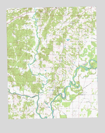
Noland, AR USGS Topographic Map
Click on map above to begin viewing in our Map Viewer.

This topographic map contains these locations and features:
Feature Name Type Latitude Longitude GNIS ID View Map
Allison Fish Lake DamDamN36.2117°W91.0401°81220View Map
Allison LakeReservoirN36.2130°W91.0405°81221View Map
Apostolic Faith CampgroundLocaleN36.2315°W91.0315°45905View Map
Bibb FarmsLocaleN36.1947°W91.0517°2630989View Map
Bibb Fish PondReservoirN36.1951°W91.0618°81223View Map
Bibb Fish Pond DamDamN36.1951°W91.0618°81222View Map
BirdellPopulated PlaceN36.2445°W91.0782°56930View Map
Birdell ChurchChurchN36.2190°W91.0971°76351View Map
Birdell Church of ChristChurchN36.2437°W91.0762°70160View Map
Birdell School (historical)SchoolN36.2190°W91.0971°70161View Map
Brown LakeLakeN36.1803°W91.0025°75661View Map
Bull Pizzle LakeLakeN36.1859°W91.0159°75665View Map
Cedar CreekStreamN36.1812°W91.0935°47596View Map
Chesser CemeteryCemeteryN36.2273°W91.0360°47732View Map
Cox Ferry (historical)CrossingN36.1603°W91.0432°60460View Map
Crooked Lake (historical)LakeN36.1367°W91.0751°60458View Map
Davidsonville (historical)Populated PlaceN36.1542°W91.0557°78903View Map
Deadman BendBendN36.1628°W91.0340°48424View Map
DunnPopulated PlaceN36.2406°W91.1057°48708View Map
Dunn CemeteryCemeteryN36.2364°W91.0923°48711View Map
Eleven Point RiverStreamN36.1508°W91.0825°76865View Map
Fairview CemeteryCemeteryN36.1753°W91.1035°48969View Map
Fairview School (historical)SchoolN36.1726°W91.1043°60457View Map
Harmony CemeteryCemeteryN36.2217°W91.0251°49866View Map
Hole in the Wall BendBendN36.1501°W91.0479°50187View Map
Horseshoe LakeLakeN36.1447°W91.0559°75743View Map
Hubble CreekStreamN36.1992°W91.0823°50379View Map
Hubble Creek Church (historical)ChurchN36.2262°W91.0560°78897View Map
Hubble Creek School (historical)SchoolN36.2251°W91.0585°60463View Map
Huffstedler CemeteryCemeteryN36.1901°W91.0510°77251View Map
Jenkins CemeteryCemeteryN36.1331°W91.0337°78381View Map
Julia Dean CreekStreamN36.1815°W91.0273°50758View Map
Kilo-Vista LakeReservoirN36.2365°W91.0824°81219View Map
Kilo-Vista Lake DamDamN36.2367°W91.0835°81218View Map
Lemmon CemeteryCemeteryN36.2151°W91.0762°77474View Map
Lemmons LakeReservoirN36.1792°W91.0721°81225View Map
Lemmons Lake DamDamN36.1784°W91.0718°81224View Map
Lester CemeteryCemeteryN36.1342°W91.0040°51073View Map
Living Farm MuseumBuildingN36.2372°W91.0839°2630988View Map
Mount Vernon ChurchChurchN36.1340°W91.1076°52430View Map
Mount Vernon School (historical)SchoolN36.1337°W91.1079°61560View Map
New Bethel Freewill Baptist ChurchChurchN36.1603°W91.0618°77807View Map
NolandPopulated PlaceN36.1934°W91.0507°77854View Map
Noland Church of ChristChurchN36.1923°W91.0512°70186View Map
Noland School (historical)SchoolN36.1928°W91.0510°70187View Map
Old Davidsonville State ParkParkN36.1578°W91.0551°52995View Map
Pleasant Hill Church (historical)ChurchN36.1462°W91.1182°61558View Map
Pleasant Hill School (historical)SchoolN36.1462°W91.1182°61559View Map
Ragan School (historical)SchoolN36.1628°W91.0190°60461View Map
Reeves CemeteryCemeteryN36.1526°W91.0585°78157View Map
RichwoodsPopulated PlaceN36.1426°W91.0118°58488View Map
Round LakeLakeN36.1378°W91.0681°75837View Map
Round Pond (historical)LakeN36.2053°W91.0123°60462View Map
Sanders CemeteryCemeteryN36.1534°W91.0209°54554View Map
Scott CemeteryCemeteryN36.1559°W91.0554°54641View Map
Scotts BendBendN36.1809°W91.0107°54649View Map
Scotts Ferry (historical)CrossingN36.1523°W91.0587°60459View Map
Straight LakeLakeN36.1419°W91.0718°75857View Map
Throop CemeteryCemeteryN36.1892°W91.0515°55563View Map
Township of ButlerCivilN36.1754°W91.1130°69017View Map
Township of East RoanokeCivilN36.1862°W91.0490°2406949View Map
Township of RichwoodsCivilN36.1290°W91.0067°66800View Map
Township of Roanoke (historical)CivilN36.1751°W91.0751°69032View Map
Township of West RoanokeCivilN36.2373°W91.0890°2407402View Map
Wilson LakeLakeN36.1593°W91.0283°75893View Map

Note: Coordinates in the location and feature list above are referenced to NAD83 datum.


Copyright (C) 2008-2024 Ryan Niemi / Sunset Dynamics ... All Rights Reserved