TopoQuest Logo
Do you find TopoQuest useful?
Help keep TopoQuest running and adding new maps/features by donating!
Bitcoin:  19c7KJd3qBynnjoSw5npx9KScwjBe4ifkT
Litecoin:  LXs6TkuXGGXo1vDsWCkWVdjQX94eUKd6ui
Home View Maps Find Maps Find Places Resources & Links


Ravenden Springs SE, Arkansas Topographic Map

USGS Map Title: Ravenden Springs SE, AR
USGS Map MRC: 36091C1
DRG (GeoTIFF) Download: o36091c1.tif


Neighboring USGS Topographic Map Quads:


  Dalton, AR  
36091D2
 

  Warm Springs, AR  
36091D1
 

  Maynard, AR  
36090D8
 

  Ravenden Springs, AR  
36091C2
 

  Ravenden Springs SE, AR  
36091C1
 

  Pocahontas, AR  
36090C8
 

  Imboden, AR  
36091B2
 

  Noland, AR  
36091B1
 

  Manson, AR  
36090B8


Map MRC Location:

N37°
W92°
N37°
W91°
H8 H7 H6 H5 H4 H3 H2 H1
G8 G7 G6 G5 G4 G3 G2 G1
F8 F7 F6 F5 F4 F3 F2 F1
E8 E7 E6 E5 E4 E3 E2 E1
D8 D7 D6 D5 D4 D3 D2 D1
C8 C7 C6 C5 C4 C3 C2 C1
B8 B7 B6 B5 B4 B3 B2 B1
A8 A7 A6 A5 A4 A3 A2 A1
N36°
W92°
N36°
W91°

Ravenden Springs SE, AR USGS 1:24K Topographic Map Preview:
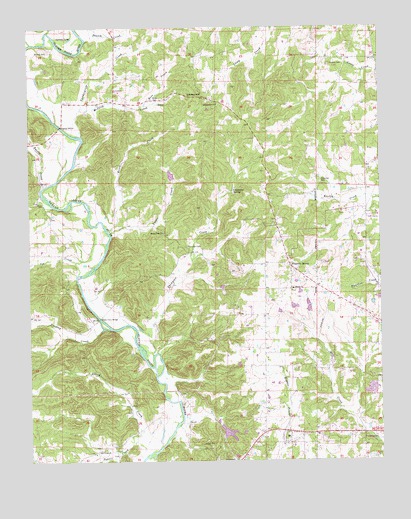
Ravenden Springs SE, AR USGS Topographic Map
Click on map above to begin viewing in our Map Viewer.

This topographic map contains these locations and features:
Feature Name Type Latitude Longitude GNIS ID View Map
Allred CreekStreamN36.2515°W91.0843°45839View Map
Black Ferry BridgeBridgeN36.2912°W91.1004°76358View Map
Blue Basin LakeReservoirN36.2581°W91.0554°79925View Map
Blue Basin Lake DamDamN36.2584°W91.0551°79924View Map
Bradley CreekStreamN36.2884°W91.0987°46895View Map
Clearview CemeteryCemeteryN36.3303°W91.0215°47842View Map
Clearview Church of Christ (historical)ChurchN36.3298°W91.0210°70164View Map
Coldwater SpringSpringN36.3278°W91.0526°47913View Map
Cooley HillSummitN36.3551°W91.0643°47990View Map
Eassis CreekStreamN36.3292°W91.1198°48747View Map
Five Mile Springs School (historical)SchoolN36.3076°W91.0326°70169View Map
Fivemile SpringSpringN36.3062°W91.0321°76933View Map
Grapesville ChurchChurchN36.3528°W91.0582°49560View Map
GravesvillePopulated PlaceN36.3540°W91.0579°70171View Map
Gravesville CemeteryCemeteryN36.3523°W91.0579°60436View Map
Gravesville School (historical)SchoolN36.3531°W91.0579°70172View Map
Jew CreekStreamN36.3042°W91.1079°50644View Map
Looney LakeLakeN36.3717°W91.1104°75776View Map
LorinePopulated PlaceN36.3070°W91.0326°60438View Map
Lost LakeReservoirN36.3324°W91.0745°81227View Map
Lost Lake DamDamN36.3317°W91.0718°81226View Map
McIlroy CemeteryCemeteryN36.3681°W91.1182°51849View Map
McIlroy CreekStreamN36.3515°W91.1065°51850View Map
New Chapel School (historical)SchoolN36.3159°W91.0773°70185View Map
Old Union Church of ChristChurchN36.2526°W91.1021°77915View Map
Old Union School (historical)SchoolN36.2528°W91.1012°70192View Map
Powell CreekStreamN36.2559°W91.0879°53745View Map
Randolph CountyCivilN36.3415°W91.0277°69178View Map
River CreekStreamN36.3156°W91.0962°54049View Map
Robinson Broiler FarmLocaleN36.2886°W91.0339°2630987View Map
Ross CemeteryCemeteryN36.3542°W91.0807°54221View Map
Ross CreekStreamN36.3526°W91.0837°54222View Map
Shiloh Baptist ChurchChurchN36.2998°W91.0315°78352View Map
Shiloh CemeteryCemeteryN36.2992°W91.0315°60437View Map
Stoney PointPopulated PlaceN36.3153°W91.0773°70206View Map
Stoney Point Freewill Baptist ChurchChurchN36.3159°W91.0773°78466View Map
Tattle CreekStreamN36.3162°W91.0957°55450View Map
Thatch CreekStreamN36.3712°W91.1043°55502View Map
Thomas CemeteryCemeteryN36.3642°W91.0179°55526View Map
Thompson CemeteryCemeteryN36.3117°W91.0696°55538View Map
Thompson CreekStreamN36.2809°W91.0812°55544View Map
Township of Eleven PointCivilN36.3564°W91.0704°69022View Map
Township of ShilohCivilN36.3054°W91.0609°69034View Map
Vandergriff CreekStreamN36.3437°W91.1060°55887View Map
Wilson CemeteryCemeteryN36.3209°W91.0146°60439View Map

Note: Coordinates in the location and feature list above are referenced to NAD83 datum.


Copyright (C) 2008-2025 Ryan Niemi / Sunset Dynamics ... All Rights Reserved