TopoQuest Logo
Do you find TopoQuest useful?
Help keep TopoQuest running and adding new maps/features by donating!
Bitcoin:  19c7KJd3qBynnjoSw5npx9KScwjBe4ifkT
Litecoin:  LXs6TkuXGGXo1vDsWCkWVdjQX94eUKd6ui
Home View Maps Find Maps Find Places Resources & Links


Noland Creek, North Carolina Topographic Map

USGS Map Title: Noland Creek, NC
USGS Map MRC: 35083D5
DRG (GeoTIFF) Download: o35083d5.tif


Neighboring USGS Topographic Map Quads:


  Thunderhead Mountain, NC  
35083E6
 

  Silers Bald, NC  
35083E5
 

  Clingmans Dome, NC  
35083E4
 

  Tuskeegee, NC  
35083D6
 

  Noland Creek, NC  
35083D5
 

  Bryson City, NC  
35083D4
 

  Hewitt, NC  
35083C6
 

  Wesser, NC  
35083C5
 

  Alarka, NC  
35083C4


Map MRC Location:

N36°
W84°
N36°
W83°
H8 H7 H6 H5 H4 H3 H2 H1
G8 G7 G6 G5 G4 G3 G2 G1
F8 F7 F6 F5 F4 F3 F2 F1
E8 E7 E6 E5 E4 E3 E2 E1
D8 D7 D6 D5 D4 D3 D2 D1
C8 C7 C6 C5 C4 C3 C2 C1
B8 B7 B6 B5 B4 B3 B2 B1
A8 A7 A6 A5 A4 A3 A2 A1
N35°
W84°
N35°
W83°

Noland Creek, NC USGS 1:24K Topographic Map Preview:
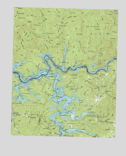
Noland Creek, NC USGS Topographic Map
Click on map above to begin viewing in our Map Viewer.

This topographic map contains these locations and features:
Feature Name Type Latitude Longitude GNIS ID View Map
Advalorem BranchStreamN35.4884°W83.5668°1008658View Map
Alarka CreekStreamN35.3984°W83.5591°1008664View Map
Alarka DockLocaleN35.3987°W83.5302°1008665View Map
Almond Park DockLocaleN35.3768°W83.5627°1008701View Map
Almond Post OfficePost OfficeN35.3772°W83.5757°2766605View Map
Ammons BranchStreamN35.3862°W83.5707°1008709View Map
Andreas BranchStreamN35.4882°W83.5018°1008730View Map
Anthony BranchStreamN35.4493°W83.6093°1008744View Map
Battles BranchStreamN35.4106°W83.5760°1008961View Map
Bear CreekStreamN35.4720°W83.5696°1008992View Map
Bearpen BranchStreamN35.4695°W83.5185°1009017View Map
Bearpen GapGapN35.4806°W83.5271°1009031View Map
Bee Gum BranchStreamN35.4951°W83.5607°1009113View Map
Bee KnobSummitN35.4856°W83.6088°1019043View Map
Bee RidgeRidgeN35.4853°W83.5750°1009114View Map
Big BranchStreamN35.4659°W83.6079°1009263View Map
Brewer BranchStreamN35.4431°W83.5577°1009590View Map
Burnett BranchStreamN35.4140°W83.5379°1009833View Map
Calfpen GapGapN35.3931°W83.6010°1009912View Map
Canebrake BranchStreamN35.4532°W83.5004°1010010View Map
Carson MillPopulated PlaceN35.4023°W83.5310°1019543View Map
Chambers BranchStreamN35.4609°W83.6132°1010154View Map
Chambers Creek GapGapN35.4895°W83.6196°1010162View Map
Cherry BranchStreamN35.4693°W83.6091°1010201View Map
Cherry GapGapN35.4790°W83.6029°1010213View Map
Cold Spring GapGapN35.4937°W83.6207°1010387View Map
Collins MountainSummitN35.4246°W83.5273°1019740View Map
Connor - Hickory Flats CemeteryCemeteryN35.4544°W83.5187°1010444View Map
Dark BranchStreamN35.3940°W83.5168°1010654View Map
Davis BranchStreamN35.3893°W83.5010°1010679View Map
Davis CemeteryCemeteryN35.3898°W83.5577°1010682View Map
Dowell DockLocaleN35.4106°W83.5396°1010899View Map
Drinklog BranchStreamN35.4948°W83.5066°1010904View Map
Evans GapGapN35.4326°W83.5479°1011115View Map
Evans KnobSummitN35.4349°W83.5520°1011116View Map
Fishtrap BranchStreamN35.4220°W83.5657°1011237View Map
Flat BranchStreamN35.4395°W83.5493°1011245View Map
Flat Branch Launch SiteLocaleN35.4387°W83.5516°1018057View Map
Flint GapGapN35.4276°W83.6249°1011286View Map
Forney CreekStreamN35.4404°W83.5643°1011340View Map
Fowler CoveValleyN35.4819°W83.6170°1011356View Map
Glady BranchStreamN35.4445°W83.5704°1011515View Map
Goldmine BranchStreamN35.4423°W83.5538°1011556View Map
Grant BranchStreamN35.3945°W83.5185°1011607View Map
Grassy BranchStreamN35.3987°W83.5352°1011623View Map
Gray Wolf CreekStreamN35.4609°W83.5599°1017946View Map
Greasy BranchStreamN35.4131°W83.5504°1011676View Map
Greasy Branch DockLocaleN35.4220°W83.5460°1011679View Map
Gunter BranchStreamN35.4545°W83.5885°1011775View Map
Hickory Flat BranchStreamN35.4426°W83.5193°1012003View Map
High RocksSummitN35.4997°W83.6212°1012048View Map
Hogpen BranchStreamN35.4804°W83.6149°1012112View Map
Holder Cove BranchStreamN35.4979°W83.5029°1012124View Map
Horse BranchStreamN35.3926°W83.6227°1012183View Map
Horse CoveValleyN35.4785°W83.5091°1012190View Map
Horseshoe RidgeRidgeN35.4086°W83.5045°1012218View Map
Hoyle CemeteryCemeteryN35.4826°W83.5733°2775252View Map
Hurricane MountainSummitN35.4246°W83.5189°1020866View Map
Hyatt BranchStreamN35.4529°W83.5507°1012315View Map
Indian CreekStreamN35.4754°W83.5143°1012338View Map
Indian Grave GapGapN35.4201°W83.5116°1012345View Map
Indian RidgeRidgeN35.4168°W83.5612°1012351View Map
Jackson Line MountainSummitN35.4134°W83.5002°1012413View Map
Jenkins BranchStreamN35.4373°W83.5246°1012450View Map
Jenkins CemeteryCemeteryN35.4315°W83.5329°1012456View Map
Jenny BranchStreamN35.4529°W83.5804°1012463View Map
Jumpup RidgeRidgeN35.4973°W83.5940°1012584View Map
Kate BranchStreamN35.4601°W83.6163°1012597View Map
Laurel BranchStreamN35.4568°W83.5274°1012701View Map
Lemmons BranchStreamN35.4018°W83.5802°1012819View Map
Little Horse BranchStreamN35.3962°W83.6210°1012973View Map
Lower Noland - Monteith CemeteryCemeteryN35.4869°W83.5093°1013243View Map
Massie GapGapN35.4715°W83.5024°1013364View Map
McClure CemeteryCemeteryN35.4472°W83.6013°1013401View Map
McHan KnobSummitN35.3816°W83.5119°1021394View Map
Meadow BranchStreamN35.4329°W83.5827°1013450View Map
Midway ChurchChurchN35.4382°W83.5004°1013524View Map
Mill CreekStreamN35.4979°W83.5021°1013559View Map
Mount Zion ChurchChurchN35.4015°W83.5329°1013783View Map
Mouse BranchStreamN35.4248°W83.6107°1013810View Map
Murphy BranchStreamN35.4120°W83.6138°1013849View Map
Murphy GapGapN35.4073°W83.5935°1013852View Map
Nantahala RiverStreamN35.3834°W83.5652°1013871View Map
Noland CreekStreamN35.4412°W83.5227°1013970View Map
North Fork Chambers CreekStreamN35.4593°W83.6102°1013992View Map
Panther CreekStreamN35.4265°W83.6127°1014209View Map
Panther Creek CemeteryCemeteryN35.4056°W83.6241°1014211View Map
Panther Creek ChurchChurchN35.3906°W83.6243°1014212View Map
Phipps CoveValleyN35.4009°W83.5521°1014376View Map
Pilot GapGapN35.4681°W83.5818°1014400View Map
Pilot KnobSummitN35.4645°W83.5730°1021898View Map
Pilot RidgeRidgeN35.4901°W83.6205°1014402View Map
Pole Bridge BranchStreamN35.4418°W83.5949°1014555View Map
Poplar CoveValleyN35.3751°W83.5277°1014580View Map
Poplar CoveValleyN35.4348°W83.5189°1014581View Map
Poplar FlatsFlatN35.4845°W83.5916°1014591View Map
Poplar Pole BranchStreamN35.4312°W83.6054°1014595View Map
Potato HillSummitN35.4132°W83.5005°1014614View Map
Reeny BranchStreamN35.4279°W83.5052°1014814View Map
Rich GapGapN35.4234°W83.5221°1014858View Map
Rinehart and White DockLocaleN35.4059°W83.6204°1014913View Map
Round TopSummitN35.3862°W83.5919°1015114View Map
Round Top CemeteryCemeteryN35.3765°W83.5888°1015116View Map
RoundhillPopulated PlaceN35.4312°W83.5249°1022430View Map
Roundhill CemeteryCemeteryN35.4323°W83.5235°1018056View Map
Sawyer CemeteryCemeteryN35.4048°W83.5349°1015303View Map
Sawyer DockLocaleN35.3968°W83.6224°1015308View Map
Shear KnobSummitN35.3914°W83.5315°1022569View Map
Slab CoveValleyN35.4969°W83.5054°1015567View Map
Solola ValleyPopulated PlaceN35.4970°W83.5007°1022701View Map
Springhouse BranchStreamN35.4718°W83.6110°1015749View Map
Stevenson BranchStreamN35.4109°W83.5549°1015825View Map
Stiles CemeteryCemeteryN35.4569°W83.5178°1015834View Map
Swain County ParkParkN35.3759°W83.5627°1015971View Map
Town BranchStreamN35.4109°W83.6154°1016199View Map
Tsali CampgroundLocaleN35.4084°W83.5885°1018059View Map
Tsali Horse TrailTrailN35.4181°W83.5879°1018058View Map
Tuckasegee RiverStreamN35.4348°W83.5846°1016248View Map
Tunnel BranchStreamN35.4498°W83.5479°1016259View Map
Tunnel RidgeRidgeN35.4700°W83.5472°1016261View Map
Turkey BranchStreamN35.3795°W83.5663°1016266View Map
Watertank BranchStreamN35.4293°W83.5710°1016468View Map
Welch BranchStreamN35.4359°W83.5910°1016499View Map
Welch BranchStreamN35.4734°W83.5685°1016500View Map
West Fork Chambers CreekStreamN35.4595°W83.6104°1016534View Map
Whiteoak BranchStreamN35.4843°W83.5638°1016610View Map
Whiteoak RidgeRidgeN35.4917°W83.5437°1016626View Map
Wolf CreekStreamN35.4601°W83.5607°1016773View Map
Woody CemeteryCemeteryN35.4698°W83.5611°1016826View Map

Note: Coordinates in the location and feature list above are referenced to NAD83 datum.


Copyright (C) 2008-2024 Ryan Niemi / Sunset Dynamics ... All Rights Reserved