TopoQuest Logo
Do you find TopoQuest useful?
Help keep TopoQuest running and adding new maps/features by donating!
Bitcoin:  19c7KJd3qBynnjoSw5npx9KScwjBe4ifkT
Litecoin:  LXs6TkuXGGXo1vDsWCkWVdjQX94eUKd6ui
Home View Maps Find Maps Find Places Resources & Links


Clingmans Dome, North Carolina Topographic Map

USGS Map Title: Clingmans Dome, NC
USGS Map MRC: 35083E4
DRG (GeoTIFF) Download: o35083e4.tif


Neighboring USGS Topographic Map Quads:


  Gatlinburg, TN  
35083F5
 

  Mount Le Conte, TN  
35083F4
 

  Mount Guyot, TN  
35083F3
 

  Silers Bald, NC  
35083E5
 

  Clingmans Dome, NC  
35083E4
 

  Smokemont, NC  
35083E3
 

  Noland Creek, NC  
35083D5
 

  Bryson City, NC  
35083D4
 

  Whittier, NC  
35083D3


Map MRC Location:

N36°
W84°
N36°
W83°
H8 H7 H6 H5 H4 H3 H2 H1
G8 G7 G6 G5 G4 G3 G2 G1
F8 F7 F6 F5 F4 F3 F2 F1
E8 E7 E6 E5 E4 E3 E2 E1
D8 D7 D6 D5 D4 D3 D2 D1
C8 C7 C6 C5 C4 C3 C2 C1
B8 B7 B6 B5 B4 B3 B2 B1
A8 A7 A6 A5 A4 A3 A2 A1
N35°
W84°
N35°
W83°

Clingmans Dome, NC USGS 1:24K Topographic Map Preview:
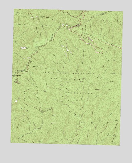
Clingmans Dome, NC USGS Topographic Map
Click on map above to begin viewing in our Map Viewer.

This topographic map contains these locations and features:
Feature Name Type Latitude Longitude GNIS ID View Map
Aden BranchStreamN35.5982°W83.3993°980054View Map
Andrews BaldSummitN35.5417°W83.4935°1018823View Map
Bald BranchStreamN35.5293°W83.4652°980460View Map
Bald Creek CampgroundLocaleN35.5298°W83.4652°980462View Map
Bearpen BranchStreamN35.5426°W83.4274°980751View Map
Bearpen RidgeRidgeN35.5584°W83.4540°980758View Map
Beetree CreekStreamN35.5545°W83.4118°980920View Map
Beetree RidgeRidgeN35.5755°W83.3948°980921View Map
Big Slick RidgeRidgeN35.5722°W83.4813°981453View Map
Bridge CreekStreamN35.5015°W83.4318°981874View Map
Bryson PlacePopulated PlaceN35.5209°W83.4190°1019352View Map
Bumgardner RidgeRidgeN35.5095°W83.4220°982243View Map
Burnt Spruce RidgeRidgeN35.5490°W83.4535°982301View Map
Cherry Cove BranchStreamN35.5054°W83.4374°1010208View Map
Cherry CreekStreamN35.5584°W83.4124°983075View Map
Clingmans CreekStreamN35.5529°W83.4716°983292View Map
Clingmans DomeSummitN35.5628°W83.4985°1326387View Map
Clingmans Dome Visitor CenterBuildingN35.5575°W83.4960°2775210View Map
Coburn KnobSummitN35.5026°W83.4646°983320View Map
Collins GapGapN35.5754°W83.4813°1281007View Map
Deep Creek GapGapN35.5590°W83.4227°984070View Map
Deeplow GapGapN35.5087°W83.3788°984107View Map
Easy RidgeRidgeN35.5276°W83.4437°984577View Map
Elliott Cove BranchStreamN35.5237°W83.4193°984731View Map
Estes BranchStreamN35.5098°W83.4002°984839View Map
Flat Top GapGapN35.5323°W83.4866°985199View Map
Fork RidgeRidgeN35.5867°W83.4668°985303View Map
Forney RidgeRidgeN35.5571°W83.4951°1011341View Map
Forney Ridge Parking AreaLocaleN35.5565°W83.4949°985313View Map
Georges BranchStreamN35.5015°W83.4010°985629View Map
Hermit BranchStreamN35.5582°W83.4321°986645View Map
Huskey CreekStreamN35.5968°W83.3946°987289View Map
Indian GapGapN35.6109°W83.4385°1000703View Map
Indian Grave FlatsFlatN35.6170°W83.4668°1288988View Map
Jack Bradley BranchStreamN35.5951°W83.3863°987461View Map
Jerry BaldSummitN35.5290°W83.4827°987576View Map
Jerry Bald RidgeRidgeN35.5380°W83.4923°987577View Map
Jerry Flats CemeteryCemeteryN35.5072°W83.4883°2775258View Map
Jim Ute BranchStreamN35.5045°W83.4899°1012479View Map
Jim Ute RidgeRidgeN35.5004°W83.4734°987609View Map
Keg Drive BranchStreamN35.5670°W83.4407°987887View Map
Left Fork Deep CreekStreamN35.5334°W83.4210°988321View Map
Lone Pine RidgeRidgeN35.5227°W83.3778°988872View Map
Long Drive RidgeRidgeN35.5642°W83.3830°988968View Map
Lower Ripshin BranchStreamN35.5093°W83.4779°989099View Map
Lower Sassafras GapGapN35.5190°W83.4540°989101View Map
Luftee GapGapN35.6076°W83.4399°989122View Map
Martins GapGapN35.5193°W83.4079°989408View Map
McCracken BranchStreamN35.5129°W83.4252°989549View Map
Mine BranchStreamN35.6040°W83.4204°990037View Map
Mingus LeadRidgeN35.6130°W83.4485°1294050View Map
Minnie Ball BranchStreamN35.6029°W83.4160°990062View Map
Moccasin BranchStreamN35.6070°W83.4657°1294135View Map
Morton OverlookLocaleN35.6170°W83.4227°1294475View Map
Mount AmblerSummitN35.6248°W83.3932°1023656View Map
Mount CollinsSummitN35.5868°W83.4724°1023657View Map
Mount Collins ShelterLocaleN35.5941°W83.4710°1652102View Map
Mount LoveSummitN35.5670°W83.4913°1023664View Map
Mount MingusSummitN35.6177°W83.4591°1306757View Map
Mount WeaverSummitN35.6056°W83.4369°1004642View Map
Nettle CreekStreamN35.5412°W83.4135°990915View Map
Nettle Creek BaldSummitN35.5666°W83.3815°1021620View Map
Newfound GapGapN35.6112°W83.4249°1000706View Map
Nicks Nest BranchStreamN35.5170°W83.4252°991151View Map
Noland DivideRidgeN35.5673°W83.4815°1013971View Map
Peruvian BranchStreamN35.6009°W83.4082°992076View Map
Poke Patch CampsiteLocaleN35.5620°W83.4188°992623View Map
Pole Road CreekStreamN35.5290°W83.4218°992633View Map
Rattlesnake KnobSummitN35.5515°W83.3987°993053View Map
Rocky ForkStreamN35.5737°W83.4252°993591View Map
Rocky Fork RidgeRidgeN35.5975°W83.4519°993594View Map
Roundtop KnobSummitN35.5488°W83.4598°993761View Map
Sahlee CreekStreamN35.5845°W83.4252°993854View Map
Salola BranchStreamN35.5434°W83.4704°994190View Map
Sassafras BranchStreamN35.5282°W83.4649°994353View Map
Sassafras KnobSummitN35.5257°W83.4529°994356View Map
Shot Beech RidgeRidgeN35.5938°W83.4177°994775View Map
Sugarland MountainSummitN35.5999°W83.4741°1271723View Map
Sunkota RidgeRidgeN35.5456°W83.3788°1015954View Map
Sweet RidgeRidgeN35.6093°W83.4781°1271975View Map
Thomas RidgeRidgeN35.6056°W83.4369°1016111View Map
Tomahawk ProngStreamN35.6123°W83.4674°1272752View Map
Turkey FlyupSummitN35.5781°W83.3857°1023002View Map
Upper Ripshin BranchStreamN35.5134°W83.4718°996558View Map
Upper Sassafras GapGapN35.5320°W83.4540°996560View Map
Watson CoveValleyN35.5265°W83.4218°996868View Map
Webb OverlookLocaleN35.5693°W83.4827°996915View Map
Wild Cherry BranchStreamN35.5940°W83.3832°997301View Map
Wilson FallsFallsN35.5892°W83.4851°1274828View Map

Note: Coordinates in the location and feature list above are referenced to NAD83 datum.


Copyright (C) 2008-2024 Ryan Niemi / Sunset Dynamics ... All Rights Reserved