TopoQuest Logo
Do you find TopoQuest useful?
Help keep TopoQuest running and adding new maps/features by donating!
Bitcoin:  19c7KJd3qBynnjoSw5npx9KScwjBe4ifkT
Litecoin:  LXs6TkuXGGXo1vDsWCkWVdjQX94eUKd6ui
Home View Maps Find Maps Find Places Resources & Links


Noontootla, Georgia Topographic Map

USGS Map Title: Noontootla, GA
USGS Map MRC: 34084F2
DRG (GeoTIFF) Download: o34084f2.tif


Neighboring USGS Topographic Map Quads:


  Blue Ridge, GA  
34084G3
 

  Wilscot, GA  
34084G2
 

  Mulky Gap, GA  
34084G1
 

  Tickanetley, GA  
34084F3
 

  Noontootla, GA  
34084F2
 

  Suches, GA  
34084F1
 

  Amicalola, GA  
34084E3
 

  Nimblewill, GA  
34084E2
 

  Campbell Mountain, GA  
34084E1


Map MRC Location:

N35°
W85°
N35°
W84°
H8 H7 H6 H5 H4 H3 H2 H1
G8 G7 G6 G5 G4 G3 G2 G1
F8 F7 F6 F5 F4 F3 F2 F1
E8 E7 E6 E5 E4 E3 E2 E1
D8 D7 D6 D5 D4 D3 D2 D1
C8 C7 C6 C5 C4 C3 C2 C1
B8 B7 B6 B5 B4 B3 B2 B1
A8 A7 A6 A5 A4 A3 A2 A1
N34°
W85°
N34°
W84°

Noontootla, GA USGS 1:24K Topographic Map Preview:
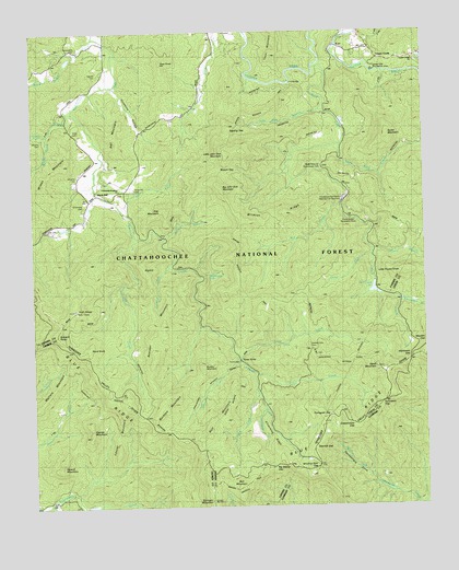
Noontootla, GA USGS Topographic Map
Click on map above to begin viewing in our Map Viewer.

This topographic map contains these locations and features:
Feature Name Type Latitude Longitude GNIS ID View Map
Alec BranchStreamN34.7037°W84.2216°330827View Map
Alec MountainSummitN34.7029°W84.2071°331016View Map
Argo (historical)Populated PlaceN34.6912°W84.1413°1704692View Map
Bailey CreekStreamN34.7079°W84.2302°326992View Map
Ball MountainSummitN34.6298°W84.1849°331084View Map
Bearden MountainSummitN34.6712°W84.2113°331112View Map
Big John Dick MountainSummitN34.7176°W84.1880°328336View Map
Big Stamp GapGapN34.6356°W84.1732°327127View Map
Black Ankle CreekStreamN34.7484°W84.2299°327140View Map
Blue Ridge Wildlife Management AreaParkN34.6615°W84.1532°330843View Map
Brushy MountainSummitN34.6615°W84.1960°331261View Map
Bryson GapGapN34.7137°W84.1896°327254View Map
Buckeye CreekStreamN34.6881°W84.2066°327266View Map
Buckeye MountainSummitN34.6526°W84.2091°331269View Map
Bucktown CreekStreamN34.6262°W84.2444°327275View Map
Bunker Hill SchoolSchoolN34.7376°W84.1966°327284View Map
Buzzard RoostSummitN34.6704°W84.2421°327313View Map
Cartecay River Watershed Dam Number SevenDamN34.6251°W84.2332°336838View Map
Chattahoochee Forest National Fish HatcheryParkN34.7051°W84.1502°2765237View Map
Chester CreekStreamN34.6726°W84.1969°330824View Map
Cooper CreekPopulated PlaceN34.7434°W84.1394°331458View Map
Cooper Creek ChurchChurchN34.7429°W84.1280°330832View Map
Coopers Creek School (historical)SchoolN34.7437°W84.1285°351082View Map
Coppermine GapGapN34.6465°W84.1471°327523View Map
Cross Trail ShelterLocaleN34.6426°W84.1932°330841View Map
Davis CreekStreamN34.6545°W84.1785°327604View Map
Deep Hole Recreation AreaLocaleN34.7404°W84.1405°330837View Map
Deerlick GapGapN34.6404°W84.1613°327625View Map
Edmondson BranchStreamN34.6795°W84.1327°327742View Map
Fannin County Fire Department Station 9BuildingN34.7416°W84.1354°2604230View Map
Fellowship Primitive ChurchChurchN34.7087°W84.2216°330831View Map
Frank Gross Recreation AreaLocaleN34.7012°W84.1482°330839View Map
Frick CreekStreamN34.6604°W84.1788°327885View Map
Frozen BranchStreamN34.6926°W84.1413°327895View Map
Fryingpan GapGapN34.6487°W84.1560°327901View Map
Garrett CemeteryCemeteryN34.7387°W84.2285°327919View Map
George MountainSummitN34.6470°W84.2324°331801View Map
Goldmine HollowValleyN34.7362°W84.2236°327956View Map
Greenway CemeteryCemeteryN34.7042°W84.2332°328007View Map
Hawk MountainSummitN34.6615°W84.1407°331929View Map
Hawks Mountain Trail ShelterLocaleN34.6612°W84.1557°330838View Map
Hickory FlatsFlatN34.6687°W84.1538°351108View Map
Hickory Flats CemeteryCemeteryN34.6676°W84.1627°328127View Map
High FallsFallsN34.7126°W84.1391°351109View Map
High HouseSummitN34.6770°W84.2363°328150View Map
Hightower GapGapN34.6637°W84.1299°328165View Map
Howell MountainSummitN34.6356°W84.2419°332036View Map
John Dick BranchStreamN34.7290°W84.1582°328335View Map
John Dick MountainsRangeN34.7151°W84.1882°330835View Map
Johnson CemeteryCemeteryN34.7217°W84.2466°328343View Map
Kirby CreekStreamN34.7290°W84.2377°328415View Map
Little Frozen KnobSummitN34.6865°W84.1313°332232View Map
Little John Dick MountainSummitN34.7181°W84.1874°330613View Map
Little LakeReservoirN34.6254°W84.2317°336839View Map
Little Rock CreekStreamN34.7190°W84.1516°328572View Map
Locust MountainSummitN34.6431°W84.2232°332254View Map
Long CreekStreamN34.6640°W84.1846°328629View Map
Lovinggood CreekStreamN34.6954°W84.2157°328655View Map
Mill CreekStreamN34.7043°W84.1516°328781View Map
Mill Creek Trout Rearing StationLocaleN34.7056°W84.1505°344293View Map
NewportPopulated PlaceN34.7229°W84.2338°332500View Map
Noontootla CemeteryCemeteryN34.7462°W84.2349°330830View Map
Noontootla ChurchChurchN34.7443°W84.2327°329043View Map
Noontootla FallsFallsN34.6859°W84.1938°330829View Map
Oliver BranchStreamN34.6912°W84.1419°330834View Map
Penitentiary CoveValleyN34.6290°W84.1379°329165View Map
Peter KnobSummitN34.7423°W84.2082°332646View Map
Puncheon GapGapN34.6523°W84.1385°329337View Map
Rall MountainSummitN34.7229°W84.2238°332786View Map
Rand KnobSummitN34.6662°W84.2332°332789View Map
Rich MountainSummitN34.6479°W84.1919°332845View Map
RipshinSummitN34.6876°W84.2146°332860View Map
Rock CreekStreamN34.7406°W84.1599°330833View Map
Rock Creek CemeteryCemeteryN34.7145°W84.1574°329459View Map
Rock Creek LakeReservoirN34.6821°W84.1409°329462View Map
Rock Creek Lake DamDamN34.6840°W84.1407°336927View Map
Rocky MountainSummitN34.7231°W84.1363°332902View Map
Sapling GapGapN34.7234°W84.1871°329592View Map
Shady Grove ChurchChurchN34.7145°W84.1577°330836View Map
Sids MountainSummitN34.7343°W84.1457°1704695View Map
Silvermine RidgeRidgeN34.6426°W84.1741°329709View Map
Springer MountainSummitN34.6273°W84.1935°356550View Map
Springer Mountain ShelterLocaleN34.6268°W84.1935°330840View Map
Stock HillPopulated PlaceN34.7076°W84.2294°333130View Map
Stock Hill CemeteryCemeteryN34.7090°W84.2174°330826View Map
Stover CreekStreamN34.6631°W84.1844°329866View Map
Three ForksPopulated PlaceN34.6640°W84.1846°333220View Map
Underwood CreekStreamN34.6512°W84.1763°330096View Map
Van Orsdal LakeReservoirN34.7426°W84.2382°336926View Map
Van Orsdal Lake DamDamN34.7434°W84.2382°336925View Map
Wallace MountainSummitN34.6579°W84.2427°333351View Map
Watkins BranchStreamN34.6962°W84.2080°330828View Map
Wildcat RidgeRidgeN34.7020°W84.1716°330280View Map
Wilson CreekStreamN34.7231°W84.2446°330312View Map
Wilson MillPopulated PlaceN34.7170°W84.2480°333440View Map
Wilson MountainSummitN34.7081°W84.2460°333442View Map
Winding Stair GapGapN34.6356°W84.1596°330318View Map

Note: Coordinates in the location and feature list above are referenced to NAD83 datum.


Copyright (C) 2008-2024 Ryan Niemi / Sunset Dynamics ... All Rights Reserved