TopoQuest Logo
Do you find TopoQuest useful?
Help keep TopoQuest running and adding new maps/features by donating!
Bitcoin:  19c7KJd3qBynnjoSw5npx9KScwjBe4ifkT
Litecoin:  LXs6TkuXGGXo1vDsWCkWVdjQX94eUKd6ui
Home View Maps Find Maps Find Places Resources & Links


Belmont, Wisconsin Topographic Map

USGS Map Title: Belmont, WI
USGS Map MRC: 42090F3
DRG (GeoTIFF) Download: o42090f3.tif


Neighboring USGS Topographic Map Quads:


  Rewey, WI  
42090G4
 

  Mifflin, WI  
42090G3
 

  Mineral Point, WI  
42090G2
 

  Platteville, WI  
42090F4
 

  Belmont, WI  
42090F3
 

  Calamine, WI  
42090F2
 

  Cuba City, WI  
42090E4
 

  New Diggings, WI  
42090E3
 

  Shullsburg, WI  
42090E2


Map MRC Location:

N43°
W91°
N43°
W90°
H8 H7 H6 H5 H4 H3 H2 H1
G8 G7 G6 G5 G4 G3 G2 G1
F8 F7 F6 F5 F4 F3 F2 F1
E8 E7 E6 E5 E4 E3 E2 E1
D8 D7 D6 D5 D4 D3 D2 D1
C8 C7 C6 C5 C4 C3 C2 C1
B8 B7 B6 B5 B4 B3 B2 B1
A8 A7 A6 A5 A4 A3 A2 A1
N42°
W91°
N42°
W90°

Belmont, WI USGS 1:24K Topographic Map Preview:
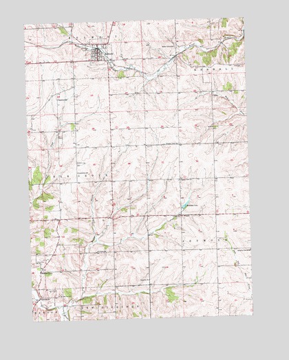
Belmont, WI USGS Topographic Map
Click on map above to begin viewing in our Map Viewer.

This topographic map contains these locations and features:
Feature Name Type Latitude Longitude GNIS ID View Map
Bachford SchoolSchoolN42.7178°W90.3574°1561057View Map
Beardsley LakeReservoirN42.6721°W90.2867°1561400View Map
BelmontPopulated PlaceN42.7361°W90.3343°1561546View Map
Belmont - Whig United Methodist ChurchChurchN42.7369°W90.3335°1989676View Map
Belmont Elementary SchoolSchoolN42.7419°W90.3265°2715696View Map
Belmont Fire DepartmentBuildingN42.7392°W90.3333°2698180View Map
Belmont Middle and High SchoolSchoolN42.7413°W90.3261°1851602View Map
Belmont Police DepartmentBuildingN42.7367°W90.3338°2759770View Map
Belmont Prairie State Natural AreaParkN42.7394°W90.3615°1988894View Map
Belmont QuarryMineN42.7375°W90.3425°2633464View Map
Belmont Wastewater Treatment FacilityLocaleN42.7333°W90.3269°2709282View Map
Bethel Grove SchoolSchoolN42.7389°W90.2904°1561644View Map
Darlington Ridge FarmsLocaleN42.6514°W90.2958°2709903View Map
Huggins QuarryMineN42.7381°W90.3414°2633689View Map
JenkinsvillePopulated PlaceN42.6347°W90.3698°1577662View Map
Leo V MineMineN42.6506°W90.3662°1567975View Map
Liberty MineMineN42.6494°W90.3715°1568015View Map
Madden BranchStreamN42.6283°W90.3562°1568877View Map
Meekers GrovePopulated PlaceN42.6456°W90.3696°1577722View Map
New Dall MineMineN42.6353°W90.3582°1570208View Map
Peace Lutheran ChurchChurchN42.7344°W90.3335°1989677View Map
Pleasant View CemeteryCemeteryN42.6828°W90.2898°1851614View Map
Pleasant View ChurchChurchN42.6828°W90.2898°1571665View Map
Pleasant View SchoolSchoolN42.6981°W90.2896°1571668View Map
Roseville ChurchChurchN42.6411°W90.3087°1572614View Map
Saint Peters Catholic CemeteryCemeteryN42.6522°W90.3329°1989684View Map
Saint Peters SchoolSchoolN42.6533°W90.3376°1573540View Map
Seymour Central SchoolSchoolN42.6528°W90.2504°1573934View Map
Strawberry CemeteryCemeteryN42.6905°W90.3471°1574974View Map
Strawberry SchoolSchoolN42.6867°W90.3474°1574979View Map
Town of Elk GroveCivilN42.6823°W90.3670°1583148View Map
Vickers SchoolSchoolN42.6675°W90.2896°1576079View Map
Village of BelmontCivilN42.7377°W90.3343°1582788View Map
Wolters FarmLocaleN42.6669°W90.3172°2709241View Map

Note: Coordinates in the location and feature list above are referenced to NAD83 datum.


Copyright (C) 2008-2024 Ryan Niemi / Sunset Dynamics ... All Rights Reserved