TopoQuest Logo
Do you find TopoQuest useful?
Help keep TopoQuest running and adding new maps/features by donating!
Bitcoin:  19c7KJd3qBynnjoSw5npx9KScwjBe4ifkT
Litecoin:  LXs6TkuXGGXo1vDsWCkWVdjQX94eUKd6ui
Home View Maps Find Maps Find Places Resources & Links


North Pownal, Maine Topographic Map

USGS Map Title: North Pownal, ME
USGS Map MRC: 43070H2
DRG (GeoTIFF) Download: o43070h2.tif


Neighboring USGS Topographic Map Quads:


  Minot, ME  
44070A3
 

  Lewiston, ME  
44070A2
 

  Lisbon Falls North, ME  
44070A1
 

  Gray, ME  
43070H3
 

  North Pownal, ME  
43070H2
 

  Lisbon Falls South, ME  
43070H1
 

  Cumberland Center, ME  
43070G3
 

  Yarmouth, ME  
43070G2
 

  Freeport, ME  
43070G1


Map MRC Location:

N44°
W71°
N44°
W70°
H8 H7 H6 H5 H4 H3 H2 H1
G8 G7 G6 G5 G4 G3 G2 G1
F8 F7 F6 F5 F4 F3 F2 F1
E8 E7 E6 E5 E4 E3 E2 E1
D8 D7 D6 D5 D4 D3 D2 D1
C8 C7 C6 C5 C4 C3 C2 C1
B8 B7 B6 B5 B4 B3 B2 B1
A8 A7 A6 A5 A4 A3 A2 A1
N43°
W71°
N43°
W70°

North Pownal, ME USGS 1:24K Topographic Map Preview:
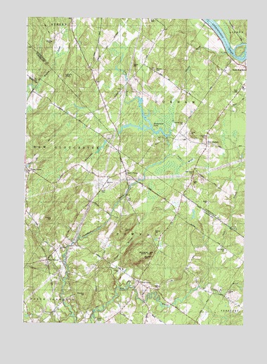
North Pownal, ME USGS Topographic Map
Click on map above to begin viewing in our Map Viewer.

This topographic map contains these locations and features:
Feature Name Type Latitude Longitude GNIS ID View Map
Alder BrookStreamN43.9445°W70.1681°561122View Map
Bibber HillSummitN43.9129°W70.1767°562108View Map
Blueberry Pond CampgroundLocaleN43.9076°W70.1412°1912186View Map
Blueberry Pond ObservatoryLocaleN43.9056°W70.1520°1912187View Map
Bowie CemeteryCemeteryN43.8799°W70.2315°2736128View Map
Bowie HillSummitN43.9798°W70.1773°562801View Map
Bradbury CemeteryCemeteryN43.9712°W70.1959°2736207View Map
Bradbury MountainSummitN43.9026°W70.1823°562849View Map
Bradbury Mountain State ParkParkN43.9051°W70.1806°562850View Map
Cedar Grove CemeteryCemeteryN43.9374°W70.1546°563717View Map
Collins BrookStreamN43.8906°W70.1503°564232View Map
Durham Community SchoolSchoolN43.9711°W70.1264°565436View Map
Durham Fire and Rescue StationBuildingN43.9746°W70.1253°2552924View Map
Dyer BrookStreamN43.9851°W70.1253°565453View Map
Elmwood CemeteryCemeteryN43.8965°W70.1953°565876View Map
First Congregational ChurchChurchN43.9806°W70.1264°1908830View Map
Foggs CornerPopulated PlaceN43.9373°W70.2478°579312View Map
Gerrish BrookStreamN43.9865°W70.1353°566756View Map
Harmony Grove CemeteryCemeteryN43.9573°W70.1595°567656View Map
Lake CemeteryCemeteryN43.9257°W70.1925°569303View Map
Lauraffe LedgeBenchN43.9765°W70.2228°569400View Map
Libby BrookStreamN43.9559°W70.1784°569511View Map
Libby HillSummitN43.9809°W70.1895°569532View Map
Libby Number 2 CemeteryCemeteryN43.9933°W70.2101°2736231View Map
Maplewood CemeteryCemeteryN43.9057°W70.2302°570748View Map
Margerison AirportAirportN43.9553°W70.1429°582176View Map
Marston HillSummitN43.8872°W70.2147°570834View Map
McKenney CemeteryCemeteryN43.9906°W70.2367°571003View Map
North PownalPopulated PlaceN43.9376°W70.1928°572398View Map
Old Friends CemeteryCemeteryN43.9061°W70.1357°572698View Map
Parker CemeteryCemeteryN43.9798°W70.1772°2729849View Map
Pisgah HillSummitN43.9172°W70.2345°573448View Map
Plummer CemeteryCemeteryN43.9997°W70.2244°2729871View Map
Pownal Airport (historical)AirportN43.8751°W70.2073°582214View Map
Pownal CenterPopulated PlaceN43.8923°W70.1853°573750View Map
Pownal Center CemeteryCemeteryN43.8931°W70.1843°2740749View Map
Pownal Elementary SchoolSchoolN43.8975°W70.1938°1912928View Map
Pownal Fire and Rescue Center StationBuildingN43.8917°W70.1828°2553208View Map
Pownal Fire and Rescue North StationBuildingN43.9375°W70.1932°2552932View Map
Pownal Post OfficePost OfficeN43.9047°W70.2315°2768944View Map
Ruby CemeteryCemeteryN43.9848°W70.2142°2736111View Map
Runaround BrookStreamN43.9445°W70.1678°574589View Map
Runaround PondReservoirN43.9545°W70.1816°574590View Map
Runaround Pond DamDamN43.9513°W70.1696°1774183View Map
South West BendPopulated PlaceN43.9806°W70.1256°575924View Map
Strout CemeteryCemeteryN43.9708°W70.1294°576446View Map
Thoits BranchStreamN43.8901°W70.1964°576978View Map
Town of DurhamCivilN43.9645°W70.1296°582448View Map
Town of PownalCivilN43.8991°W70.1818°582684View Map
Tryon MountainSummitN43.9137°W70.1939°577379View Map
Tuttle CemeteryCemeteryN43.8898°W70.1483°2736254View Map
Warren CemeteryCemeteryN43.9003°W70.2282°2736258View Map
Waterhouse CemeteryCemeteryN43.9739°W70.2102°2736118View Map
West DurhamPopulated PlaceN43.9492°W70.1473°578129View Map
West PownalPopulated PlaceN43.9006°W70.2370°578207View Map

Note: Coordinates in the location and feature list above are referenced to NAD83 datum.


Copyright (C) 2008-2024 Ryan Niemi / Sunset Dynamics ... All Rights Reserved