TopoQuest Logo
Do you find TopoQuest useful?
Help keep TopoQuest running and adding new maps/features by donating!
Bitcoin:  19c7KJd3qBynnjoSw5npx9KScwjBe4ifkT
Litecoin:  LXs6TkuXGGXo1vDsWCkWVdjQX94eUKd6ui
Home View Maps Find Maps Find Places Resources & Links


Belzoni, Mississippi Topographic Map

USGS Map Title: Belzoni, MS
USGS Map MRC: 33090B4
DRG (GeoTIFF) Download: o33090b4.tif


Neighboring USGS Topographic Map Quads:


  Inverness, MS  
33090C5
 

  Swiftown, MS  
33090C4
 

  Montgomery, MS  
33090C3
 

  Bellewood, MS  
33090B5
 

  Belzoni, MS  
33090B4
 

  Marcella, MS  
33090B3
 

  Midnight, MS  
33090A5
 

  Silver City, MS  
33090A4
 

  Thornton, MS  
33090A3


Map MRC Location:

N34°
W91°
N34°
W90°
H8 H7 H6 H5 H4 H3 H2 H1
G8 G7 G6 G5 G4 G3 G2 G1
F8 F7 F6 F5 F4 F3 F2 F1
E8 E7 E6 E5 E4 E3 E2 E1
D8 D7 D6 D5 D4 D3 D2 D1
C8 C7 C6 C5 C4 C3 C2 C1
B8 B7 B6 B5 B4 B3 B2 B1
A8 A7 A6 A5 A4 A3 A2 A1
N33°
W91°
N33°
W90°

Belzoni, MS USGS 1:24K Topographic Map Preview:
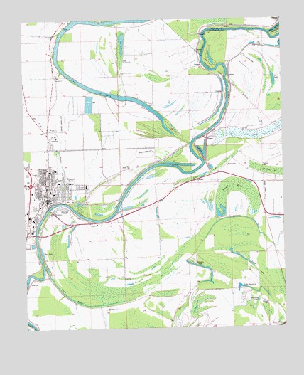
Belzoni, MS USGS Topographic Map
Click on map above to begin viewing in our Map Viewer.

This topographic map contains these locations and features:
Feature Name Type Latitude Longitude GNIS ID View Map
Bear CreekStreamN33.2498°W90.4423°666646View Map
BelzoniPopulated PlaceN33.1843°W90.4893°666815View Map
Belzoni Fire DepartmentBuildingN33.1773°W90.4916°2665680View Map
Belzoni Lagoon DamDamN33.1568°W90.4951°681887View Map
Belzoni Landing (historical)LocaleN33.1762°W90.4829°706997View Map
Belzoni Police DepartmentBuildingN33.1801°W90.4890°2754106View Map
Belzoni Post OfficePost OfficeN33.1764°W90.4873°2768627View Map
Blue HoleLakeN33.1561°W90.4918°684942View Map
BrooklynPopulated PlaceN33.1726°W90.4865°667595View Map
Burtonia Landing (historical)LocaleN33.1632°W90.4951°707001View Map
Callao Landing (historical)LocaleN33.1632°W90.4940°707002View Map
Calvary ChurchChurchN33.1676°W90.4651°667938View Map
Carson CemeteryCemeteryN33.1432°W90.4979°668101View Map
City of BelzoniCivilN33.1805°W90.4863°2403852View Map
Deadman LakeLakeN33.1965°W90.4143°684947View Map
DeovolentePopulated PlaceN33.2193°W90.4501°691812View Map
Deovolente SchoolSchoolN33.2337°W90.4506°669235View Map
Ditch Number EighteenCanalN33.2412°W90.4940°666090View Map
Ditch Number Twenty OneCanalN33.2268°W90.4954°666091View Map
Ditch Number Twenty SevenCanalN33.1818°W90.4951°666093View Map
Ditch Number Twenty SixCanalN33.1712°W90.4959°666092View Map
Fairview Landing (historical)LocaleN33.1765°W90.4540°707006View Map
Famolsa Landing (historical)LocaleN33.2154°W90.4040°707007View Map
FamoslaPopulated PlaceN33.2387°W90.3901°691857View Map
Famosla Cut-OffBendN33.2465°W90.3762°669906View Map
Fisk BayouGutN33.2060°W90.4870°670001View Map
Fullilove CemeteryCemeteryN33.1351°W90.3834°684951View Map
Fullilove LakeLakeN33.1361°W90.3882°684952View Map
Grass LakePopulated PlaceN33.1707°W90.3834°691901View Map
Gum BayouGutN33.1379°W90.4790°670781View Map
Gun Bayou Landing (historical)LocaleN33.1465°W90.4912°707014View Map
Hawkins Lake DamDamN33.1485°W90.4751°681879View Map
Holly Grove CemeteryCemeteryN33.1810°W90.4267°671313View Map
Holly Grove ChurchChurchN33.1812°W90.4268°671321View Map
Honey IslandPopulated PlaceN33.1265°W90.3773°684959View Map
Honey IslandIslandN33.1260°W90.3829°671382View Map
Humphreys County Elementary SchoolSchoolN33.1901°W90.4876°707019View Map
Humphreys County Fire and RescueBuildingN33.1899°W90.4994°2665867View Map
Humphreys County High SchoolSchoolN33.1854°W90.4848°707020View Map
Humphreys County Junior High SchoolSchoolN33.1843°W90.4851°707021View Map
Humphreys County Sheriff's OfficeBuildingN33.1746°W90.4886°2754243View Map
Humphreys County Vocational ComplexSchoolN33.1840°W90.4834°707023View Map
Jims Island Landing (historical)LocaleN33.2426°W90.4129°706500View Map
King David ChurchChurchN33.2240°W90.3984°672159View Map
King David SchoolSchoolN33.2240°W90.3984°672160View Map
Lake DiscoveryLakeN33.1413°W90.3938°684949View Map
Long LakeLakeN33.1546°W90.3982°669166View Map
Lousy Level Landing (historical)LocaleN33.2329°W90.4293°707028View Map
Macedonia CemeteryCemeteryN33.2262°W90.4842°672987View Map
Macedonia ChurchChurchN33.2262°W90.4843°673011View Map
Mahrud (historical)LocaleN33.1868°W90.4093°684963View Map
Mahrud Landing (historical)LocaleN33.1918°W90.4129°707029View Map
MathenaPopulated PlaceN33.1910°W90.3848°707032View Map
Mathena CemeteryCemeteryN33.1910°W90.3837°673232View Map
Mathena ChurchChurchN33.1910°W90.3837°673233View Map
Maxwells Landing (historical)LocaleN33.1471°W90.4990°707033View Map
Mount Everet CemeteryCemeteryN33.2329°W90.4506°673990View Map
Mount Everet ChurchChurchN33.2329°W90.4506°673992View Map
Mount Heaver I ChurchChurchN33.1348°W90.4540°674017View Map
Mount Heaver II ChurchChurchN33.1376°W90.4401°674018View Map
Mount Zion CemeteryCemeteryN33.2054°W90.4845°684967View Map
Mount Zion ChurchChurchN33.2060°W90.4834°674378View Map
Ole LakeLakeN33.2408°W90.4518°675281View Map
Patients' Choice Medical CenterHospitalN33.1828°W90.4699°707022View Map
Paul Roberts Lake DamDamN33.2135°W90.4668°681922View Map
Paul Thorton Lake DamDamN33.2035°W90.3751°681916View Map
Payne School (historical)SchoolN33.1873°W90.4081°684970View Map
Pelican BendBendN33.2485°W90.3754°684225View Map
Sheltonia Landing (historical)LocaleN33.1904°W90.4279°707043View Map
Shiloh-Deovolente ChurchChurchN33.2285°W90.4520°684984View Map
Snake CreekStreamN33.2026°W90.4134°677957View Map
Supervisor District 4CivilN33.1811°W90.4093°711888View Map
Thornton Lake DamDamN33.2435°W90.4418°681953View Map
Toney BrakeSwampN33.1827°W90.3971°678817View Map
Townson LakeLakeN33.1502°W90.4161°678847View Map
Wasp LakeLakeN33.2183°W90.4489°679363View Map
Wasp Lake Landing (historical)LocaleN33.1990°W90.4198°707051View Map
Watson ChapelChurchN33.1904°W90.4023°679381View Map
Welchs Camp Landing (historical)LocaleN33.1904°W90.4134°707053View Map
WELZ-AM (Belzoni)TowerN33.1732°W90.4812°680127View Map
Whiskey Slough Landing (historical)LocaleN33.1854°W90.4462°707055View Map
Winter Quarters Landing (historical)LocaleN33.2073°W90.4056°707057View Map
Woodland CemeteryCemeteryN33.1907°W90.4504°679841View Map
Woodland ChurchChurchN33.1907°W90.4504°679845View Map
Woodland SchoolSchoolN33.1907°W90.4504°679847View Map
Youngs Landing (historical)LocaleN33.1879°W90.4415°707058View Map

Note: Coordinates in the location and feature list above are referenced to NAD83 datum.


Copyright (C) 2008-2025 Ryan Niemi / Sunset Dynamics ... All Rights Reserved