TopoQuest Logo
Do you find TopoQuest useful?
Help keep TopoQuest running and adding new maps/features by donating!
Bitcoin:  19c7KJd3qBynnjoSw5npx9KScwjBe4ifkT
Litecoin:  LXs6TkuXGGXo1vDsWCkWVdjQX94eUKd6ui
Home View Maps Find Maps Find Places Resources & Links


Odell NE, Nebraska Topographic Map

USGS Map Title: Odell NE, NE
USGS Map MRC: 40096B7
DRG (GeoTIFF) Download: o40096b7.tif


Neighboring USGS Topographic Map Quads:


  Plymouth, NE  
40096C8
 

  Beatrice West, NE  
40096C7
 

  Beatrice East, NE  
40096C6
 

  Harbine, NE  
40096B8
 

  Odell NE, NE  
40096B7
 

  Blue Springs, NE  
40096B6
 

  Diller, NE  
40096A8
 

  Odell, NE  
40096A7
 

  Wymore, NE  
40096A6


Map MRC Location:

N41°
W97°
N41°
W96°
H8 H7 H6 H5 H4 H3 H2 H1
G8 G7 G6 G5 G4 G3 G2 G1
F8 F7 F6 F5 F4 F3 F2 F1
E8 E7 E6 E5 E4 E3 E2 E1
D8 D7 D6 D5 D4 D3 D2 D1
C8 C7 C6 C5 C4 C3 C2 C1
B8 B7 B6 B5 B4 B3 B2 B1
A8 A7 A6 A5 A4 A3 A2 A1
N40°
W97°
N40°
W96°

Odell NE, NE USGS 1:24K Topographic Map Preview:
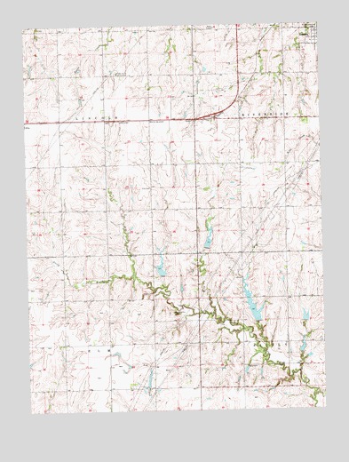
Odell NE, NE USGS Topographic Map
Click on map above to begin viewing in our Map Viewer.

This topographic map contains these locations and features:
Feature Name Type Latitude Longitude GNIS ID View Map
Big Indian Creek Dam 12-1DamN40.1534°W96.7585°1768597View Map
Big Indian Creek Dam 12-ADamN40.1433°W96.7601°1768595View Map
Big Indian Creek Dam 13-BDamN40.1537°W96.7779°1768679View Map
Big Indian Creek Dam 13-CDamN40.1775°W96.7994°1768677View Map
Big Indian Creek Dam 14-ADamN40.1687°W96.8183°1768675View Map
Big Indian Creek Dam 14-BDamN40.1678°W96.8270°1769062View Map
Big Indian Creek Reservoir 12-1LakeN40.1546°W96.7582°1768598View Map
Big Indian Creek Reservoir 13-BLakeN40.1566°W96.7792°1768680View Map
Big Indian Creek Reservoir 13-CReservoirN40.1805°W96.7983°1768678View Map
Big Indian Creek Reservoir 14-ALakeN40.1713°W96.8187°1768676View Map
Big Indian Creek Reservoir 14-BReservoirN40.1672°W96.8267°1769063View Map
Big Indian Greek Reservoir 12-ALakeN40.1448°W96.7595°1768596View Map
Ellis CemeteryCemeteryN40.1975°W96.8228°829070View Map
Hidden Acres Country ClubLocaleN40.2344°W96.8364°836048View Map
Hidden Acres Golf ClubLocaleN40.2361°W96.8017°1883159View Map
Linsenmeyer FarmsLocaleN40.2181°W96.8056°2585742View Map
Pleasant Hill CemeteryCemeteryN40.1567°W96.8136°832170View Map
Snyder DamDamN40.1333°W96.8253°1767697View Map
Snyder ReservoirReservoirN40.1350°W96.8245°1767698View Map
Township of ElmCivilN40.1323°W96.8597°837987View Map
Township of LincolnCivilN40.2193°W96.8598°838094View Map

Note: Coordinates in the location and feature list above are referenced to NAD83 datum.


Copyright (C) 2008-2025 Ryan Niemi / Sunset Dynamics ... All Rights Reserved