TopoQuest Logo
Do you find TopoQuest useful?
Help keep TopoQuest running and adding new maps/features by donating!
Bitcoin:  19c7KJd3qBynnjoSw5npx9KScwjBe4ifkT
Litecoin:  LXs6TkuXGGXo1vDsWCkWVdjQX94eUKd6ui
Home View Maps Find Maps Find Places Resources & Links


Oil Springs, Kentucky Topographic Map

USGS Map Title: Oil Springs, KY
USGS Map MRC: 37082G8
DRG (GeoTIFF) Download: o37082g8.tif


Neighboring USGS Topographic Map Quads:


  Dingus, KY  
37083H1
 

  Redbush, KY  
37082H8
 

  Sitka, KY  
37082H7
 

  Salyersville North, KY  
37083G1
 

  Oil Springs, KY  
37082G8
 

  Paintsville, KY  
37082G7
 

  Salyersville South, KY  
37083F1
 

  Ivyton, KY  
37082F8
 

  Prestonsburg, KY  
37082F7


Map MRC Location:

N38°
W83°
N38°
W82°
H8 H7 H6 H5 H4 H3 H2 H1
G8 G7 G6 G5 G4 G3 G2 G1
F8 F7 F6 F5 F4 F3 F2 F1
E8 E7 E6 E5 E4 E3 E2 E1
D8 D7 D6 D5 D4 D3 D2 D1
C8 C7 C6 C5 C4 C3 C2 C1
B8 B7 B6 B5 B4 B3 B2 B1
A8 A7 A6 A5 A4 A3 A2 A1
N37°
W83°
N37°
W82°

Oil Springs, KY USGS 1:24K Topographic Map Preview:
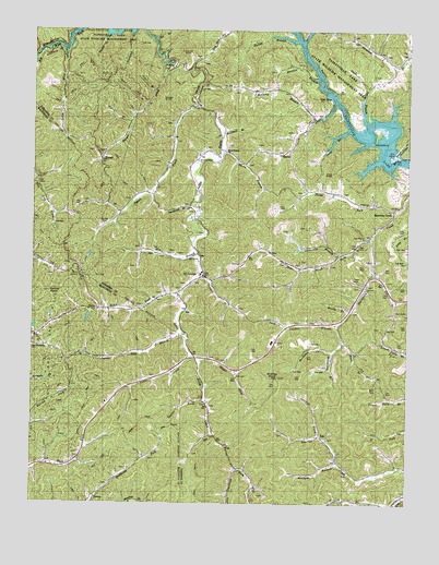
Oil Springs, KY USGS Topographic Map
Click on map above to begin viewing in our Map Viewer.

This topographic map contains these locations and features:
Feature Name Type Latitude Longitude GNIS ID View Map
Adams CemeteryCemeteryN37.7847°W82.9617°2338980View Map
AsaPopulated PlaceN37.7679°W82.9041°507419View Map
Ballot ChurchChurchN37.7929°W82.9182°510018View Map
Barnetts CreekPopulated PlaceN37.8279°W82.8796°507457View Map
Blair BranchStreamN37.7920°W82.8960°487436View Map
Blair CemeteryCemeteryN37.7809°W82.8874°487439View Map
Blanton BranchStreamN37.8604°W82.9043°487470View Map
Buckhorn BranchStreamN37.8484°W82.9371°488264View Map
Cane BranchStreamN37.8493°W82.8946°488765View Map
Cane KnobSummitN37.8376°W82.8991°510028View Map
Cantrill ForkStreamN37.7679°W82.9027°488906View Map
Caudill BranchStreamN37.8090°W82.9402°489104View Map
Caudill ForkStreamN37.7714°W82.9996°2339005View Map
Colvin BranchStreamN37.8109°W82.8866°489890View Map
Colvin BranchStreamN37.8568°W82.8999°489891View Map
ConleyPopulated PlaceN37.7518°W82.9782°507745View Map
Conley CemeteryCemeteryN37.8237°W82.9760°489967View Map
Cotton KnobSummitN37.8059°W82.9941°490147View Map
Davis BranchStreamN37.8429°W82.9368°490638View Map
Davis Branch ChurchChurchN37.8431°W82.9363°490643View Map
Dry BranchStreamN37.8162°W82.9446°491151View Map
Fairview ChurchChurchN37.8070°W82.8882°510017View Map
Fairview SchoolSchoolN37.8070°W82.8891°491933View Map
Fish TrapLocaleN37.8579°W82.9013°492108View Map
Frank Prater CemeteryCemeteryN37.7620°W82.9581°2339040View Map
Frazier BranchStreamN37.8511°W82.9676°492478View Map
Glade BranchStreamN37.8504°W82.8885°492872View Map
Goose CreekStreamN37.7898°W82.9463°492997View Map
Goose Creek School (historical)SchoolN37.7818°W82.9656°2339048View Map
Green Valley SchoolSchoolN37.7929°W82.8949°493304View Map
Gullett BranchStreamN37.8729°W82.9121°493468View Map
HargisPopulated PlaceN37.8415°W82.9771°508188View Map
Hargis CreekStreamN37.8634°W82.9568°493742View Map
Hitchcork BranchStreamN37.7904°W82.9002°494311View Map
Hurricane BranchStreamN37.8156°W82.8977°494811View Map
Jack Caudill BranchStreamN37.7973°W82.8982°495073View Map
Little Mine ForkStreamN37.8701°W82.9893°496803View Map
Little Mine Fork SchoolSchoolN37.8545°W82.9904°496804View Map
Locust KnobSummitN37.8706°W82.9502°510027View Map
Low Gap SchoolSchoolN37.8687°W82.9435°497244View Map
Low Gap United Baptist ChurchChurchN37.8606°W82.9443°497237View Map
ManilaPopulated PlaceN37.8429°W82.9154°510029View Map
Manila Post OfficePost OfficeN37.8429°W82.9171°510128View Map
Marshal Early BridgeBridgeN37.8172°W82.8936°2096005View Map
Mash Fork Missionary Baptist ChurchChurchN37.7765°W82.9867°2339090View Map
Mashfork Post Office (historical)Post OfficeN37.7593°W82.9874°510130View Map
McCarty BranchStreamN37.8520°W82.9068°497776View Map
Moody BranchStreamN37.8015°W82.8935°498519View Map
Oil BranchStreamN37.8731°W82.9607°499782View Map
Oil SpringsPopulated PlaceN37.8101°W82.9424°499786View Map
Oil Springs ChurchChurchN37.8295°W82.8874°510020View Map
Oil Springs ChurchChurchN37.8654°W82.9518°510021View Map
Oil Springs DivisionCivilN37.7754°W82.8972°1937180View Map
Oil Springs Volunteer Fire DepartmentBuildingN37.8110°W82.9447°2636902View Map
Old Little Paint ChurchChurchN37.8406°W82.9441°510022View Map
Painters Lick (historical)Populated PlaceN37.7892°W82.9699°2339111View Map
Painters Lick BranchStreamN37.7945°W82.9499°500126View Map
Painters Lick SchoolSchoolN37.7887°W82.9716°500127View Map
Paintsville LakeReservoirN37.8501°W82.8894°509958View Map
Pet Ex SchoolSchoolN37.7945°W82.9971°500449View Map
Pickle ForkStreamN37.8276°W82.8796°500561View Map
Piegon ChurchChurchN37.8306°W82.9752°510019View Map
Pigeon CreekStreamN37.8551°W82.9463°500586View Map
Pigeon SchoolSchoolN37.8345°W82.9588°500597View Map
Pine BranchStreamN37.8591°W82.9606°510025View Map
Potato KnobSummitN37.8568°W82.9566°510026View Map
Poundmill BranchStreamN37.8290°W82.9474°501224View Map
Rocky BranchStreamN37.8681°W82.9991°502236View Map
Rowland BranchStreamN37.8745°W82.9679°502429View Map
Salyer ForkStreamN37.7884°W82.9452°502861View Map
Saylor ForkStreamN37.7773°W82.9413°503027View Map
Shack BranchStreamN37.8743°W82.9752°503200View Map
Span BranchStreamN37.8554°W82.9618°510024View Map
State Road ForkStreamN37.8209°W82.8874°504279View Map
State Road ForkStreamN37.8048°W82.9504°504281View Map
State Road Fork ChurchChurchN37.7915°W82.9993°510023View Map
Stuffley KnobSummitN37.7831°W82.9202°504605View Map
Tackett CemeteryCemeteryN37.8351°W82.8774°504908View Map
Tick Lick SchoolSchoolN37.8318°W82.9963°505270View Map
Wheelersburg Post Office (historical)Post OfficeN37.8113°W82.9913°2123337View Map
Wheelersburg Post Office (historical)Post OfficeN37.8113°W82.9913°2339150View Map
Wolfpen BranchStreamN37.7615°W82.8977°507049View Map

Note: Coordinates in the location and feature list above are referenced to NAD83 datum.


Copyright (C) 2008-2025 Ryan Niemi / Sunset Dynamics ... All Rights Reserved