TopoQuest Logo
Do you find TopoQuest useful?
Help keep TopoQuest running and adding new maps/features by donating!
Bitcoin:  19c7KJd3qBynnjoSw5npx9KScwjBe4ifkT
Litecoin:  LXs6TkuXGGXo1vDsWCkWVdjQX94eUKd6ui
Home View Maps Find Maps Find Places Resources & Links


Ojitos Frios, New Mexico Topographic Map

USGS Map Title: Ojitos Frios, NM
USGS Map MRC: 35105E3
DRG (GeoTIFF) Download: o35105e3.tif


Neighboring USGS Topographic Map Quads:


  El Porvenir, NM  
35105F4
 

  Montezuma, NM  
35105F3
 

  Las Vegas NW, NM  
35105F2
 

  San Geronimo, NM  
35105E4
 

  Ojitos Frios, NM  
35105E3
 

  Las Vegas, NM  
35105E2
 

  San Jose, NM  
35105D4
 

  Tecolote, NM  
35105D3
 

  Los Montoyas, NM  
35105D2


Map MRC Location:

N36°
W106°
N36°
W105°
H8 H7 H6 H5 H4 H3 H2 H1
G8 G7 G6 G5 G4 G3 G2 G1
F8 F7 F6 F5 F4 F3 F2 F1
E8 E7 E6 E5 E4 E3 E2 E1
D8 D7 D6 D5 D4 D3 D2 D1
C8 C7 C6 C5 C4 C3 C2 C1
B8 B7 B6 B5 B4 B3 B2 B1
A8 A7 A6 A5 A4 A3 A2 A1
N35°
W106°
N35°
W105°

Ojitos Frios, NM USGS 1:24K Topographic Map Preview:
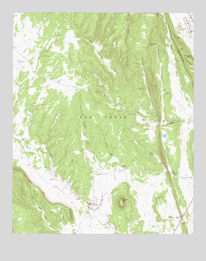
Ojitos Frios, NM USGS Topographic Map
Click on map above to begin viewing in our Map Viewer.

This topographic map contains these locations and features:
Feature Name Type Latitude Longitude GNIS ID View Map
Agua ZarcaPopulated PlaceN35.5634°W105.2720°903021View Map
Box RanchLocaleN35.6150°W105.2978°904039View Map
Camp Maximiliano LunaLocaleN35.6187°W105.2564°915805View Map
Camp Maximiliano Luna Historical MarkerParkN35.6187°W105.2564°932234View Map
Caņada de Cabo LuceroStreamN35.5206°W105.3133°904399View Map
Caņon CarrizalosoValleyN35.5820°W105.3728°904631View Map
Caņon MesteņoValleyN35.5803°W105.3720°904667View Map
Caņon Piedra LumbreValleyN35.5706°W105.2972°904677View Map
Devils GulchValleyN35.6078°W105.2764°905739View Map
Forest RanchLocaleN35.5973°W105.3717°906329View Map
King StadiumParkN35.6109°W105.2592°928969View Map
La Canada del Alto de la ReuniStreamN35.5206°W105.3133°907614View Map
La MangaPopulated PlaceN35.5095°W105.2639°907682View Map
La Manga CemeteryCemeteryN35.5094°W105.2620°931206View Map
LagunasPopulated PlaceN35.5292°W105.3381°907809View Map
Las Vegas TownPopulated PlaceN35.6006°W105.2550°2038785View Map
Ojito Frio Number 1SpringN35.5459°W105.3000°914268View Map
Ojito Frio Number 2SpringN35.5445°W105.2978°914279View Map
Ojitos FriosPopulated PlaceN35.5167°W105.3175°909283View Map
Ojitos Frios CreekStreamN35.5137°W105.3189°909284View Map
Ojitos Frios RanchLocaleN35.5384°W105.3000°909285View Map
Santo Niņo ChurchChurchN35.5092°W105.2622°910806View Map
Tecolote PeakSummitN35.5200°W105.3000°911579View Map
The CrestonRidgeN35.6045°W105.2603°911629View Map

Note: Coordinates in the location and feature list above are referenced to NAD83 datum.


Copyright (C) 2008-2025 Ryan Niemi / Sunset Dynamics ... All Rights Reserved