TopoQuest Logo
Do you find TopoQuest useful?
Help keep TopoQuest running and adding new maps/features by donating!
Bitcoin:  19c7KJd3qBynnjoSw5npx9KScwjBe4ifkT
Litecoin:  LXs6TkuXGGXo1vDsWCkWVdjQX94eUKd6ui
Home View Maps Find Maps Find Places Resources & Links


Okeene, Oklahoma Topographic Map

USGS Map Title: Okeene, OK
USGS Map MRC: 36098A3
DRG (GeoTIFF) Download: o36098a3.tif


Neighboring USGS Topographic Map Quads:


  Homestead, OK  
36098B4
 

  Isabella, OK  
36098B3
 

  Ames, OK  
36098B2
 

  Southard, OK  
36098A4
 

  Okeene, OK  
36098A3
 

  Parvin, OK  
36098A2
 

  Watonga Lake, OK  
35098H4
 

  Hitchcock, OK  
35098H3
 

  Loyal NW, OK  
35098H2


Map MRC Location:

N37°
W99°
N37°
W98°
H8 H7 H6 H5 H4 H3 H2 H1
G8 G7 G6 G5 G4 G3 G2 G1
F8 F7 F6 F5 F4 F3 F2 F1
E8 E7 E6 E5 E4 E3 E2 E1
D8 D7 D6 D5 D4 D3 D2 D1
C8 C7 C6 C5 C4 C3 C2 C1
B8 B7 B6 B5 B4 B3 B2 B1
A8 A7 A6 A5 A4 A3 A2 A1
N36°
W99°
N36°
W98°

Okeene, OK USGS 1:24K Topographic Map Preview:
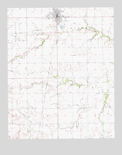
Okeene, OK USGS Topographic Map
Click on map above to begin viewing in our Map Viewer.

This topographic map contains these locations and features:
Feature Name Type Latitude Longitude GNIS ID View Map
Arkansas-White-Red Region - 2-digit Hydrologic Unit Code - 11AreaN36.0834°W98.3714°2730142View Map
Brickman CemeteryCemeteryN36.0583°W98.3082°1851625View Map
Christman AirfieldAirportN36.1140°W98.3074°1102591View Map
Church of ChristChurchN36.1200°W98.3153°1801309View Map
Ebenfeld CemeteryCemeteryN36.0800°W98.2991°1092471View Map
First Baptist ChurchChurchN36.1206°W98.3176°1801310View Map
First Christian ChurchChurchN36.1134°W98.3162°1801311View Map
First United Methodist ChurchChurchN36.1131°W98.3162°1801312View Map
Lamle AirportAirportN36.0702°W98.2890°1102592View Map
OkeenePopulated PlaceN36.1161°W98.3170°1096197View Map
Okeene Assembly of God ChurchChurchN36.1203°W98.3203°1801313View Map
Okeene DivisionCivilN36.0911°W98.3306°1937814View Map
Okeene Elementary SchoolSchoolN36.1186°W98.3149°1794277View Map
Okeene Emergency Medical ServicesBuildingN36.1152°W98.3179°2695841View Map
Okeene Fire DepartmentBuildingN36.1152°W98.3179°2658260View Map
Okeene Junior High SchoolSchoolN36.1186°W98.3159°1794276View Map
Okeene Municipal HospitalHospitalN36.1166°W98.3152°2695736View Map
Okeene Police DepartmentBuildingN36.1152°W98.3181°2757484View Map
Okeene Senior High SchoolSchoolN36.1185°W98.3167°2712913View Map
Okeene Sewage Disposal Pond NorthReservoirN36.1073°W98.3123°1752642View Map
Okeene Sewage Disposal Pond North DamDamN36.1067°W98.3120°1752641View Map
Okeene Sewage Disposal Pond SouthReservoirN36.1056°W98.3116°1752644View Map
Okeene Sewage Disposal Pond South DamDamN36.1050°W98.3103°1752643View Map
Peaceful CemeteryCemeteryN36.0216°W98.3520°1096493View Map
Roselawn CemeteryCemeteryN36.1099°W98.2988°1097455View Map
Saint Anthonys Catholic ChurchChurchN36.1139°W98.3159°1801315View Map
Saint John United ChurchChurchN36.1200°W98.3165°1801316View Map
Seventh Day Adventist ChurchChurchN36.1189°W98.3290°1801314View Map
Tonkawa Creek Site 4 DamDamN36.0250°W98.2720°1758727View Map
Tonkawa Creek Site 4 ReservoirReservoirN36.0250°W98.2720°1758728View Map
Town of OkeeneCivilN36.1171°W98.3165°2413076View Map
Township of CimarronCivilN36.1084°W98.2920°1825485View Map
Township of FlynnCivilN36.0306°W98.3698°1825490View Map
Township of SeayCivilN36.0306°W98.2642°1825481View Map
Tulles CemeteryCemeteryN36.0440°W98.2998°1099009View Map

Note: Coordinates in the location and feature list above are referenced to NAD83 datum.


Copyright (C) 2008-2025 Ryan Niemi / Sunset Dynamics ... All Rights Reserved