TopoQuest Logo
Do you find TopoQuest useful?
Help keep TopoQuest running and adding new maps/features by donating!
Bitcoin:  19c7KJd3qBynnjoSw5npx9KScwjBe4ifkT
Litecoin:  LXs6TkuXGGXo1vDsWCkWVdjQX94eUKd6ui
Home View Maps Find Maps Find Places Resources & Links


Okmulgee South, Oklahoma Topographic Map

USGS Map Title: Okmulgee South, OK
USGS Map MRC: 35095E8
DRG (GeoTIFF) Download: o35095e8.tif


Neighboring USGS Topographic Map Quads:


  Beggs, OK  
35096F1
 

  Okmulgee North, OK  
35095F8
 

  Okmulgee NE, OK  
35095F7
 

  Okmulgee Lake, OK  
35096E1
 

  Okmulgee South, OK  
35095E8
 

  Morris, OK  
35095E7
 

  Pharoah, OK  
35096D1
 

  Henryetta, OK  
35095D8
 

  Hoffman, OK  
35095D7


Map MRC Location:

N36°
W96°
N36°
W95°
H8 H7 H6 H5 H4 H3 H2 H1
G8 G7 G6 G5 G4 G3 G2 G1
F8 F7 F6 F5 F4 F3 F2 F1
E8 E7 E6 E5 E4 E3 E2 E1
D8 D7 D6 D5 D4 D3 D2 D1
C8 C7 C6 C5 C4 C3 C2 C1
B8 B7 B6 B5 B4 B3 B2 B1
A8 A7 A6 A5 A4 A3 A2 A1
N35°
W96°
N35°
W95°

Okmulgee South, OK USGS 1:24K Topographic Map Preview:
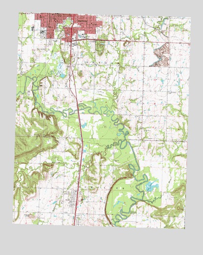
Okmulgee South, OK USGS Topographic Map
Click on map above to begin viewing in our Map Viewer.

This topographic map contains these locations and features:
Feature Name Type Latitude Longitude GNIS ID View Map
2000 CenterLocaleN35.6034°W95.9614°1763823View Map
2000 Shopping CenterLocaleN35.6034°W95.9614°1778014View Map
4 - States Academy of CosmetologySchoolN35.6229°W95.9685°2713065View Map
Abundant Life ChurchChurchN35.6148°W95.9781°1809688View Map
Assembly of God East SideChurchN35.6218°W95.9594°1809689View Map
Bethel TempleChurchN35.6148°W95.9789°1809691View Map
Big Cussetah CemeteryCemeteryN35.5566°W95.9064°2709113View Map
Big Cussetah ChurchChurchN35.5576°W95.9061°1090108View Map
BrundidgePopulated PlaceN35.5918°W95.9625°1763724View Map
Burgess CreekStreamN35.5348°W95.9492°1090710View Map
Butler Methodist ChurchChurchN35.6187°W95.9581°1809692View Map
Calvary Baptist ChurchChurchN35.6154°W95.9542°1809693View Map
Catholic Sisters ConventChurchN35.6226°W95.9625°1809694View Map
Church of ChristChurchN35.6209°W95.9728°1809695View Map
City of OkmulgeeCivilN35.6040°W95.9811°2411312View Map
Creek National CapitolParkN35.6228°W95.9725°2491537View Map
Cussetah CreekStreamN35.5707°W95.9350°1091899View Map
Deep Fork National Wildlife RefugeBuildingN35.5731°W95.9566°2657338View Map
Deep Fork National Wildlife RefugeParkN35.5663°W95.9629°2765266View Map
Eastside Elementary SchoolSchoolN35.6207°W95.9519°1819252View Map
Elephant KnobSummitN35.5048°W95.9872°1092521View Map
Emerson SchoolSchoolN35.6126°W95.9633°1092616View Map
Episcopal Church of the RedeemerChurchN35.6243°W95.9742°1809698View Map
First Assembly of GodChurchN35.6248°W95.9742°1809700View Map
First Baptist ChurchChurchN35.6240°W95.9744°1809701View Map
First Christian ChurchChurchN35.6215°W95.9736°1809702View Map
First Presbyterian ChurchChurchN35.6218°W95.9742°1809703View Map
Flag LakeReservoirN35.5245°W95.9009°1092868View Map
Franklin SchoolSchoolN35.6168°W95.9772°1093019View Map
Grayson CemeteryCemeteryN35.5118°W95.8758°1093352View Map
Greenwood LakeReservoirN35.6119°W95.9556°1093407View Map
Jubilee Christian AcademySchoolN35.6133°W95.9775°2712836View Map
KOKL-AM (Okmulgee)TowerN35.6087°W95.9722°1102212View Map
KTHK-FM (Okmulgee)TowerN35.6087°W95.9722°1102290View Map
Little Cussetah CemeteryCemeteryN35.5803°W95.8903°1094748View Map
Little Cussetah ChurchChurchN35.5043°W95.9822°1094750View Map
Long BranchStreamN35.6187°W95.8986°1094948View Map
Lutheran Church of the TrinityChurchN35.6240°W95.9550°1809706View Map
Marian AcademySchoolN35.6179°W95.9731°1819257View Map
Mission Lane Shopping CenterLocaleN35.6245°W95.9450°1763821View Map
Montezuma CreekStreamN35.5507°W95.9231°1095489View Map
Moore CreekStreamN35.5165°W95.9067°1095499View Map
Moore Creek CemeteryCemeteryN35.5514°W95.8825°2709114View Map
Muscogee Creek Nation Medical CenterHospitalN35.6112°W95.9524°2695693View Map
New Zion ChurchChurchN35.5512°W95.8805°1095848View Map
Oakwood CemeteryCemeteryN35.6146°W95.9729°1096167View Map
OkmulgeePopulated PlaceN35.6234°W95.9606°1096218View Map
Okmulgee CemeteryCemeteryN35.6000°W95.9587°1096219View Map
Okmulgee Country ClubLocaleN35.6093°W95.9444°1102057View Map
Okmulgee County Emergency Medical Services HeadquartersBuildingN35.6103°W95.9556°2695906View Map
Okmulgee County Sheriff's OfficeBuildingN35.6218°W95.9746°2757671View Map
Okmulgee CreekStreamN35.5865°W95.9858°1096220View Map
Okmulgee Elementary SchoolSchoolN35.6195°W95.9470°1093926View Map
Okmulgee Fire Department Station 2BuildingN35.6216°W95.9554°2657024View Map
Okmulgee Police DepartmentBuildingN35.6237°W95.9725°2757591View Map
Okmulgee Post OfficePost OfficeN35.6248°W95.9722°1818099View Map
Okmulgee Wildlife Management AreaBuildingN35.6102°W95.9155°2657418View Map
Pawhuska CemeteryCemeteryN35.5395°W95.9281°1096477View Map
Praise and Worship Apostolic ChurchChurchN35.6248°W95.9533°1809709View Map
Roosevelt SchoolSchoolN35.6223°W95.9847°1097421View Map
Saint Anthony ChurchChurchN35.6187°W95.9731°1809712View Map
SchulterPopulated PlaceN35.5145°W95.9567°1097872View Map
Schulter Elementary SchoolSchoolN35.5142°W95.9590°1790753View Map
Schulter High SchoolSchoolN35.5142°W95.9590°1790463View Map
Schulter Post OfficePost OfficeN35.5178°W95.9560°1818604View Map
Schulter Volunteer Fire DepartmentBuildingN35.5151°W95.9553°2657357View Map
Southwest CemeteryCemeteryN35.5890°W95.9978°1098314View Map
Southwood PlazaLocaleN35.6065°W95.9628°1763822View Map
Thousand Acre LakeReservoirN35.5887°W95.9678°1098868View Map
Town of SchulterCivilN35.5109°W95.9566°2413265View Map
Township of SchulterCivilN35.5223°W95.9419°1824891View Map
Township of SeversCivilN35.5959°W95.9531°1824889View Map
United Pentecostal ChurchChurchN35.6159°W95.9506°1809710View Map
Woodlawn CemeteryCemeteryN35.6007°W95.9569°1099991View Map

Note: Coordinates in the location and feature list above are referenced to NAD83 datum.


Copyright (C) 2008-2024 Ryan Niemi / Sunset Dynamics ... All Rights Reserved