TopoQuest Logo
Do you find TopoQuest useful?
Help keep TopoQuest running and adding new maps/features by donating!
Bitcoin:  19c7KJd3qBynnjoSw5npx9KScwjBe4ifkT
Litecoin:  LXs6TkuXGGXo1vDsWCkWVdjQX94eUKd6ui
Home View Maps Find Maps Find Places Resources & Links


Okmulgee Lake, Oklahoma Topographic Map

USGS Map Title: Okmulgee Lake, OK
USGS Map MRC: 35096E1
DRG (GeoTIFF) Download: o35096e1.tif


Neighboring USGS Topographic Map Quads:


  Nuyaka, OK  
35096F2
 

  Beggs, OK  
35096F1
 

  Okmulgee North, OK  
35095F8
 

  Okfuskee, OK  
35096E2
 

  Okmulgee Lake, OK  
35096E1
 

  Okmulgee South, OK  
35095E8
 

  Clearview, OK  
35096D2
 

  Pharoah, OK  
35096D1
 

  Henryetta, OK  
35095D8


Map MRC Location:

N36°
W97°
N36°
W96°
H8 H7 H6 H5 H4 H3 H2 H1
G8 G7 G6 G5 G4 G3 G2 G1
F8 F7 F6 F5 F4 F3 F2 F1
E8 E7 E6 E5 E4 E3 E2 E1
D8 D7 D6 D5 D4 D3 D2 D1
C8 C7 C6 C5 C4 C3 C2 C1
B8 B7 B6 B5 B4 B3 B2 B1
A8 A7 A6 A5 A4 A3 A2 A1
N35°
W97°
N35°
W96°

Okmulgee Lake, OK USGS 1:24K Topographic Map Preview:
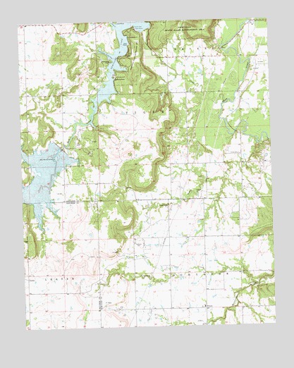
Okmulgee Lake, OK USGS Topographic Map
Click on map above to begin viewing in our Map Viewer.

This topographic map contains these locations and features:
Feature Name Type Latitude Longitude GNIS ID View Map
Carpenters PointCapeN35.6090°W96.0778°1090989View Map
Edwards CemeteryCemeteryN35.5343°W96.0679°1092495View Map
Fourmile CreekStreamN35.5168°W96.0092°1092993View Map
Honey CreekStreamN35.5757°W96.0069°1093881View Map
Honey Creek ChurchChurchN35.5495°W96.0525°1093886View Map
Indian CemeteryCemeteryN35.5547°W96.0376°1094076View Map
Lions PointCapeN35.6245°W96.0753°1094705View Map
Mount Zion CemeteryCemeteryN35.6180°W96.0261°2724237View Map
Okmulgee DamDamN35.6217°W96.0620°1757307View Map
Okmulgee LakeReservoirN35.6113°W96.0759°1096221View Map
Okmulgee State ParkParkN35.6004°W96.0597°1763725View Map
Okmulgee State ParkBuildingN35.6119°W96.0684°2657342View Map
Okmulgee WaterworksLocaleN35.6240°W96.0086°1096223View Map
Oknoname 111006 DamDamN35.6201°W96.1019°1753487View Map
Oknoname 111006 ReservoirReservoirN35.6198°W96.1030°1753488View Map
Oknoname 111007 DamDamN35.6201°W96.0903°1753491View Map
Oknoname 111007 ReservoirReservoirN35.6197°W96.0898°1753492View Map
Salt CreekStreamN35.5912°W96.0228°1097686View Map
Salt Creek Site S-1 DamDamN35.5725°W96.1035°1751858View Map
Salt Creek Site S-1 ReservoirReservoirN35.5618°W96.1172°1751859View Map
Salvation Army CoveBayN35.6123°W96.0803°1097711View Map
Seascout PointCapeN35.6009°W96.0764°1097895View Map
Sharp CemeteryCemeteryN35.5705°W96.0164°1097958View Map
SunrisePopulated PlaceN35.5207°W96.1231°1100866View Map
Township of TigerCivilN35.5862°W96.0808°1824886View Map
WilsonPopulated PlaceN35.5076°W96.0347°1099875View Map
Wilson Elementary SchoolSchoolN35.5084°W96.0358°1099903View Map
Wilson High SchoolSchoolN35.5082°W96.0353°2712843View Map
Wilson Volunteer Fire DepartmentBuildingN35.5068°W96.0350°2657389View Map

Note: Coordinates in the location and feature list above are referenced to NAD83 datum.


Copyright (C) 2008-2025 Ryan Niemi / Sunset Dynamics ... All Rights Reserved