TopoQuest Logo
Do you find TopoQuest useful?
Help keep TopoQuest running and adding new maps/features by donating!
Bitcoin:  19c7KJd3qBynnjoSw5npx9KScwjBe4ifkT
Litecoin:  LXs6TkuXGGXo1vDsWCkWVdjQX94eUKd6ui
Home View Maps Find Maps Find Places Resources & Links


Oliphant Butte, Montana Topographic Map

USGS Map Title: Oliphant Butte, MT
USGS Map MRC: 45105F2
DRG (GeoTIFF) Download: o45105f2.tif


Neighboring USGS Topographic Map Quads:


  Rattlesnake Hill, MT  
45105G3
 

  Snake Butte, MT  
45105G2
 

  Powderville, MT  
45105G1
 

  Cross S School, MT  
45105F3
 

  Oliphant Butte, MT  
45105F2
 

  Rattlesnake Ridge, MT  
45105F1
 

  Hawkey Creek, MT  
45105E3
 

  Deer Creek Buttes, MT  
45105E2
 

  McKenzie Creek, MT  
45105E1


Map MRC Location:

N46°
W106°
N46°
W105°
H8 H7 H6 H5 H4 H3 H2 H1
G8 G7 G6 G5 G4 G3 G2 G1
F8 F7 F6 F5 F4 F3 F2 F1
E8 E7 E6 E5 E4 E3 E2 E1
D8 D7 D6 D5 D4 D3 D2 D1
C8 C7 C6 C5 C4 C3 C2 C1
B8 B7 B6 B5 B4 B3 B2 B1
A8 A7 A6 A5 A4 A3 A2 A1
N45°
W106°
N45°
W105°

Oliphant Butte, MT USGS 1:24K Topographic Map Preview:
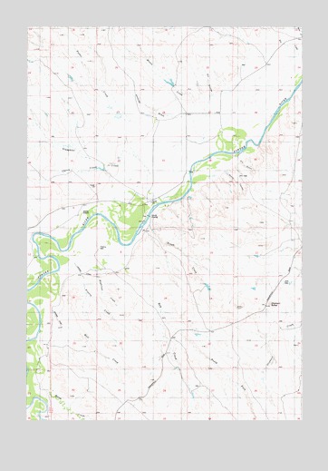
Oliphant Butte, MT USGS Topographic Map
Click on map above to begin viewing in our Map Viewer.

This topographic map contains these locations and features:
Feature Name Type Latitude Longitude GNIS ID View Map
01S53E21DDCB01 WellWellN45.7317°W105.1830°811500View Map
01S53E29CA__01 WellWellN45.7203°W105.2108°811400View Map
01S53E29DBBD01 WellWellN45.7211°W105.2078°811408View Map
01S53E34CBCD01 WellWellN45.7067°W105.1666°811301View Map
02S52E24DBDA01 WellWellN45.6458°W105.2472°810780View Map
02S53E28AABA01 WellWellN45.6411°W105.1808°810749View Map
02S53E30ADCD01 WellWellN45.6347°W105.2228°810712View Map
Cherry CreekStreamN45.6989°W105.2122°768047View Map
Dry CouleeValleyN45.7286°W105.1669°770760View Map
Dry CreekStreamN45.7414°W105.1269°770770View Map
Dry GulchValleyN45.7089°W105.1547°770832View Map
Foster CreekStreamN45.7194°W105.1994°771535View Map
Hay CreekStreamN45.6744°W105.2061°772246View Map
Hillside DrawValleyN45.7211°W105.1839°772423View Map
Horse CreekStreamN45.6336°W105.2403°772541View Map
Jurica School (historical)SchoolN45.6906°W105.2272°772921View Map
Mason CreekStreamN45.7247°W105.1750°773916View Map
Matt CreekStreamN45.6536°W105.2441°773929View Map
Mushroom CreekStreamN45.6725°W105.2361°774520View Map
North Fork Hay CreekStreamN45.6594°W105.1897°774764View Map
Oliphant ButteSummitN45.6622°W105.1400°774951View Map
Olson CouleeValleyN45.7044°W105.1608°774961View Map
Prairie CreekStreamN45.6694°W105.2244°775432View Map
Rough CreekStreamN45.6883°W105.1941°775963View Map
Rough CreekStreamN45.7022°W105.1683°775964View Map
Sixmile CrossingPopulated PlaceN45.6906°W105.1941°776592View Map
Slaughter CreekStreamN45.7036°W105.1769°776630View Map
Tepee HillSummitN45.6994°W105.2191°777471View Map

Note: Coordinates in the location and feature list above are referenced to NAD83 datum.


Copyright (C) 2008-2024 Ryan Niemi / Sunset Dynamics ... All Rights Reserved