TopoQuest Logo
Do you find TopoQuest useful?
Help keep TopoQuest running and adding new maps/features by donating!
Bitcoin:  19c7KJd3qBynnjoSw5npx9KScwjBe4ifkT
Litecoin:  LXs6TkuXGGXo1vDsWCkWVdjQX94eUKd6ui
Home View Maps Find Maps Find Places Resources & Links


Oracle Junction, Arizona Topographic Map

USGS Map Title: Oracle Junction, AZ
USGS Map MRC: 32110E8
DRG (GeoTIFF) Download: o32110e8.tif


Neighboring USGS Topographic Map Quads:


  Chief Butte, AZ  
32111F1
 

  Fortified Peak, AZ  
32110F8
 

  North of Oracle, AZ  
32110F7
 

  Tortolita Mountains, AZ  
32111E1
 

  Oracle Junction, AZ  
32110E8
 

  Oracle, AZ  
32110E7
 

  Ruelas Canyon, AZ  
32111D1
 

  Oro Valley, AZ  
32110D8
 

  Mount Lemmon, AZ  
32110D7


Map MRC Location:

N33°
W111°
N33°
W110°
H8 H7 H6 H5 H4 H3 H2 H1
G8 G7 G6 G5 G4 G3 G2 G1
F8 F7 F6 F5 F4 F3 F2 F1
E8 E7 E6 E5 E4 E3 E2 E1
D8 D7 D6 D5 D4 D3 D2 D1
C8 C7 C6 C5 C4 C3 C2 C1
B8 B7 B6 B5 B4 B3 B2 B1
A8 A7 A6 A5 A4 A3 A2 A1
N32°
W111°
N32°
W110°

Oracle Junction, AZ USGS 1:24K Topographic Map Preview:
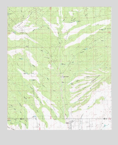
Oracle Junction, AZ USGS Topographic Map
Click on map above to begin viewing in our Map Viewer.

This topographic map contains these locations and features:
Feature Name Type Latitude Longitude GNIS ID View Map
Black Tank WellWellN32.5726°W110.9493°1636View Map
Bowl CreekStreamN32.5562°W110.9607°1893View Map
Carpas WashStreamN32.5431°W110.9359°2472View Map
CatalinaPopulated PlaceN32.5056°W110.9211°37213View Map
Catalina WellWellN32.5687°W110.9226°2560View Map
Chalk ReservoirReservoirN32.5140°W110.9666°2731View Map
Chirreon WashStreamN32.5023°W110.9279°2879View Map
Copper CreekStreamN32.5370°W110.9351°3222View Map
Crescent RavineValleyN32.6059°W110.9590°3565View Map
Crescent TankReservoirN32.5991°W110.9911°23687View Map
Cruz WashStreamN32.5878°W110.9376°3622View Map
Deep WellWellN32.5337°W110.9648°3786View Map
Double TankReservoirN32.5824°W110.9054°4057View Map
Falcon DivideRidgeN32.6101°W110.9804°4536View Map
Falcon ValleyValleyN32.5731°W110.9454°4537View Map
Falcon Valley RanchLocaleN32.5876°W110.9404°4538View Map
Faraway TankReservoirN32.5722°W110.9828°4550View Map
Faraway WashStreamN32.5431°W110.9362°4551View Map
Fox Ravine (historical)ValleyN32.5590°W110.9359°4813View Map
Golder Ranch Fire District Station 373BuildingN32.5356°W110.8862°2672509View Map
Golder Ranch Fire District Station 378BuildingN32.5844°W110.9164°2672656View Map
Indian Town ReservoirReservoirN32.5096°W110.9961°6242View Map
Indian Well WashStreamN32.5137°W110.9787°6247View Map
Lower Holding TankReservoirN32.5670°W110.9354°7470View Map
Lower Sahuarita Dam (historical)DamN32.5376°W110.9854°7503View Map
Martin Ranch Airstrip (historical)AirportN32.5209°W110.9437°23746View Map
Mountain View Country ClubLocaleN32.5275°W110.8976°2670472View Map
Nelson RanchLocaleN32.5154°W110.9279°8574View Map
Oracle JunctionPopulated PlaceN32.5551°W110.9334°24547View Map
Oracle SubstationLocaleN32.6009°W110.9826°9003View Map
Page-Trowbridge Experimental RanchLocaleN32.6128°W110.8898°43201View Map
Pinal County Parkway Rest AreaLocaleN32.5862°W110.9451°23774View Map
Pinal County Sheriff's Office Saddlebrooke Region BBuildingN32.5353°W110.8876°2751707View Map
Power Line ReservoirReservoirN32.5508°W110.9706°9726View Map
Power Line TankReservoirN32.6179°W110.9983°9727View Map
Rail N RanchLocaleN32.5029°W110.8859°9907View Map
Rainbows End WashStreamN32.5678°W110.9248°33339View Map
Represo TankReservoirN32.5484°W110.9320°10221View Map
Sierra Tucson Residential Treatment HospitalHospitalN32.5168°W110.8875°2667624View Map
Small Hill ReservoirReservoirN32.5576°W110.9766°11449View Map
Tascal RavineValleyN32.5459°W110.9268°12183View Map
Tascal TankReservoirN32.5474°W110.9237°12184View Map
The CordonesSummitN32.5434°W110.9043°12305View Map
Threeway GulchValleyN32.6101°W110.9295°40443View Map
Threeway TankReservoirN32.6102°W110.9157°12435View Map
Threeway WashStreamN32.6109°W110.9318°12436View Map
Twentynine WashStreamN32.5190°W110.9312°12922View Map
Upper Holding RavineArroyoN32.5709°W110.9362°40449View Map
Upper Holding TankReservoirN32.6019°W110.8849°13093View Map
Upper Sahuarita DamDamN32.5498°W110.9940°13116View Map
Walnut WellWellN32.5526°W110.9340°13331View Map
Well TwentynineWellN32.5273°W110.9195°13445View Map
Well TwentysevenWellN32.5306°W110.8948°13444View Map

Note: Coordinates in the location and feature list above are referenced to NAD83 datum.


Copyright (C) 2008-2025 Ryan Niemi / Sunset Dynamics ... All Rights Reserved