TopoQuest Logo
Do you find TopoQuest useful?
Help keep TopoQuest running and adding new maps/features by donating!
Bitcoin:  19c7KJd3qBynnjoSw5npx9KScwjBe4ifkT
Litecoin:  LXs6TkuXGGXo1vDsWCkWVdjQX94eUKd6ui
Home View Maps Find Maps Find Places Resources & Links


Oraville, Illinois Topographic Map

USGS Map Title: Oraville, IL
USGS Map MRC: 37089G4
DRG (GeoTIFF) Download: o37089g4.tif


Neighboring USGS Topographic Map Quads:


  Willisville, IL  
37089H5
 

  Ava, IL  
37089H4
 

  Vergennes, IL  
37089H3
 

  Raddle, IL  
37089G5
 

  Oraville, IL  
37089G4
 

  Murphysboro, IL  
37089G3
 

  Altenburg, MO  
37089F5
 

  Gorham, IL  
37089F4
 

  Pomona, IL  
37089F3


Map MRC Location:

N38°
W90°
N38°
W89°
H8 H7 H6 H5 H4 H3 H2 H1
G8 G7 G6 G5 G4 G3 G2 G1
F8 F7 F6 F5 F4 F3 F2 F1
E8 E7 E6 E5 E4 E3 E2 E1
D8 D7 D6 D5 D4 D3 D2 D1
C8 C7 C6 C5 C4 C3 C2 C1
B8 B7 B6 B5 B4 B3 B2 B1
A8 A7 A6 A5 A4 A3 A2 A1
N37°
W90°
N37°
W89°

Oraville, IL USGS 1:24K Topographic Map Preview:
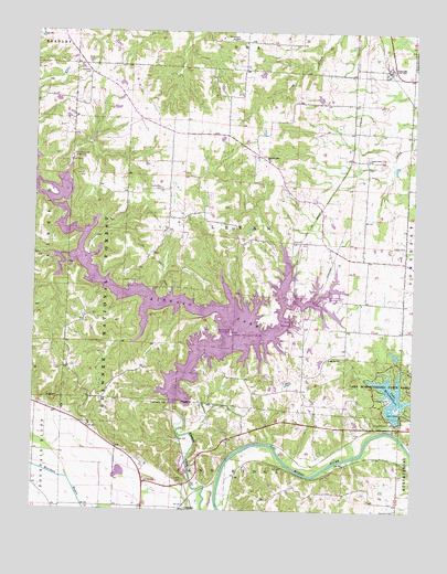
Oraville, IL USGS Topographic Map
Click on map above to begin viewing in our Map Viewer.

This topographic map contains these locations and features:
Feature Name Type Latitude Longitude GNIS ID View Map
Bald Knob Picnic AreaLocaleN37.7745°W89.3829°1815589View Map
Bartlett CemeteryCemeteryN37.8642°W89.4826°403942View Map
Big Oak CampgroundLocaleN37.7795°W89.3831°1815591View Map
Buttermilk Hill Beach and Picnic AreaLocaleN37.7962°W89.4398°1772182View Map
Camp Creek Baptist ChurchChurchN37.8417°W89.3901°405459View Map
Clear View Picnic AreaLocaleN37.7764°W89.3795°1815599View Map
Creath Morris CemeteryCemeteryN37.7578°W89.4501°406762View Map
Crisenberry DamDamN37.7778°W89.4540°406791View Map
Glenn Schlimpert Recreation AreaParkN37.8056°W89.4034°1772199View Map
GrimsbyPopulated PlaceN37.7503°W89.4493°409513View Map
Jackson CountyCivilN37.7851°W89.3821°424240View Map
Kinkaid LakeReservoirN37.8050°W89.4604°411524View Map
Lake MurphysboroReservoirN37.7801°W89.3813°414251View Map
Lake Murphysboro State ParkParkN37.7826°W89.3820°411725View Map
Lake Shore Drive Picnic AreaLocaleN37.7834°W89.3812°1815614View Map
Levan TownhallBuildingN37.8206°W89.4151°1772208View Map
Lone Oak CemeteryCemeteryN37.8339°W89.4587°412537View Map
Mount Joy ChurchChurchN37.7898°W89.4020°413989View Map
Mount Pleasant Station (historical)LocaleN37.7626°W89.3959°1815619View Map
Oak Point Picnic AreaLocaleN37.7814°W89.3843°1815622View Map
OravillePopulated PlaceN37.8651°W89.3834°415158View Map
Paul Ice Recreation AreaParkN37.8056°W89.4154°1772226View Map
Pine Circle Picnic AreaLocaleN37.7798°W89.3781°1815627View Map
Pleasant Hill Christian ChurchChurchN37.8414°W89.4234°415826View Map
Rendleman AirportAirportN37.7557°W89.3821°2679067View Map
Ripley CemeteryCemeteryN37.8192°W89.3776°416691View Map
Shady Cove Picnic AreaLocaleN37.7773°W89.3762°1815631View Map
Shady Rest CampgroundLocaleN37.7853°W89.3856°1815632View Map
Sharp Rock Falls CampgroundLocaleN37.8420°W89.4882°1772233View Map
Sodom School (historical)SchoolN37.8298°W89.4554°1772235View Map
Township of LevanCivilN37.8212°W89.4331°429248View Map
Union School (historical)SchoolN37.8651°W89.4318°1772242View Map
Walbieser School (historical)SchoolN37.7931°W89.4595°1772246View Map
Water Lily CampgroundLocaleN37.7856°W89.3898°1815639View Map
Williamson CemeteryCemeteryN37.8728°W89.4334°421215View Map
Worthen CemeteryCemeteryN37.7503°W89.3795°421511View Map
WXAN-FM (Ava)TowerN37.8553°W89.4684°428119View Map

Note: Coordinates in the location and feature list above are referenced to NAD83 datum.


Copyright (C) 2008-2024 Ryan Niemi / Sunset Dynamics ... All Rights Reserved