TopoQuest Logo
Do you find TopoQuest useful?
Help keep TopoQuest running and adding new maps/features by donating!
Bitcoin:  19c7KJd3qBynnjoSw5npx9KScwjBe4ifkT
Litecoin:  LXs6TkuXGGXo1vDsWCkWVdjQX94eUKd6ui
Home View Maps Find Maps Find Places Resources & Links


Raddle, Illinois Topographic Map

USGS Map Title: Raddle, IL
USGS Map MRC: 37089G5
DRG (GeoTIFF) Download: o37089g5.tif


Neighboring USGS Topographic Map Quads:


  Welge, IL  
37089H6
 

  Willisville, IL  
37089H5
 

  Ava, IL  
37089H4
 

  Rockwood, IL  
37089G6
 

  Raddle, IL  
37089G5
 

  Oraville, IL  
37089G4
 

  Crosstown, MO  
37089F6
 

  Altenburg, MO  
37089F5
 

  Gorham, IL  
37089F4


Map MRC Location:

N38°
W90°
N38°
W89°
H8 H7 H6 H5 H4 H3 H2 H1
G8 G7 G6 G5 G4 G3 G2 G1
F8 F7 F6 F5 F4 F3 F2 F1
E8 E7 E6 E5 E4 E3 E2 E1
D8 D7 D6 D5 D4 D3 D2 D1
C8 C7 C6 C5 C4 C3 C2 C1
B8 B7 B6 B5 B4 B3 B2 B1
A8 A7 A6 A5 A4 A3 A2 A1
N37°
W90°
N37°
W89°

Raddle, IL USGS 1:24K Topographic Map Preview:
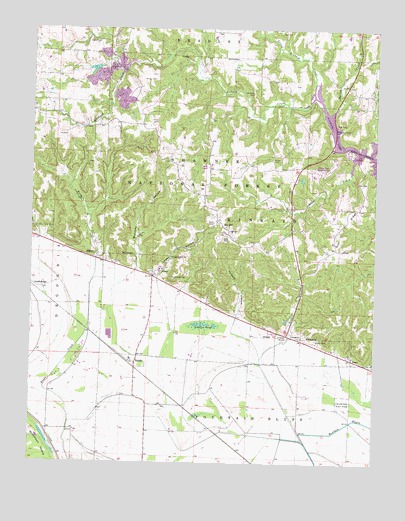
Raddle, IL USGS Topographic Map
Click on map above to begin viewing in our Map Viewer.

This topographic map contains these locations and features:
Feature Name Type Latitude Longitude GNIS ID View Map
Aldrich School (historical)SchoolN37.8145°W89.6184°1772169View Map
Austin HollowValleyN37.7871°W89.5311°403739View Map
Big Lake School (historical)SchoolN37.7634°W89.5359°1772173View Map
Bower CemeteryCemeteryN37.8378°W89.5376°404731View Map
Bower School (historical)SchoolN37.8389°W89.5348°1772175View Map
CrainPopulated PlaceN37.7801°W89.5079°422588View Map
Crain School (historical)SchoolN37.7792°W89.5084°1772188View Map
Douglas School (historical)SchoolN37.8431°W89.5765°1772193View Map
Dry HillPopulated PlaceN37.8173°W89.5534°422637View Map
Franklin School (historical)SchoolN37.7595°W89.6084°1772198View Map
GlennPopulated PlaceN37.8037°W89.5807°422742View Map
Gum RidgeRidgeN37.8189°W89.5115°409564View Map
Johnson CreekStreamN37.8392°W89.5057°411161View Map
Johnson Creek Recreation AreaParkN37.8342°W89.5209°1815613View Map
Jones CemeteryCemeteryN37.8478°W89.5812°411204View Map
Kinkaid Number 1 QuarryMineN37.8637°W89.5962°1986090View Map
Koehn CemeteryCemeteryN37.8714°W89.6018°411595View Map
Lee CemeteryCemeteryN37.8117°W89.5126°411907View Map
Little Kinkaid CreekStreamN37.8553°W89.5226°412365View Map
Logan HollowValleyN37.8036°W89.5794°412512View Map
Logan Hollow ChurchChurchN37.8092°W89.5740°412513View Map
Logan School (historical)SchoolN37.8059°W89.5762°1772210View Map
Lovets PondLakeN37.7896°W89.5622°412697View Map
Matusky BrookStreamN37.7909°W89.5959°1772215View Map
Matusky HollowValleyN37.8057°W89.5870°413133View Map
McBride CemeteryCemeteryN37.8567°W89.5451°413183View Map
McCormick CemeteryCemeteryN37.8034°W89.5743°413224View Map
RaddlePopulated PlaceN37.7789°W89.5868°416341View Map
Reeds Creek Landing Airport (historical)AirportN37.7928°W89.6032°427033View Map
Spring CreekStreamN37.8498°W89.5176°418936View Map
Swamp Hollow School (historical)SchoolN37.7653°W89.5754°1772237View Map
Talbot School (historical)SchoolN37.8206°W89.5107°1772238View Map
Talbott CemeteryCemeteryN37.7859°W89.5215°419523View Map
Talbott HollowValleyN37.7930°W89.5501°419524View Map
Township of KinkaidCivilN37.8235°W89.5437°429211View Map
Will School (historical)SchoolN37.8567°W89.5020°1772248View Map
Wilson CemeteryCemeteryN37.8603°W89.5854°421284View Map

Note: Coordinates in the location and feature list above are referenced to NAD83 datum.


Copyright (C) 2008-2025 Ryan Niemi / Sunset Dynamics ... All Rights Reserved