TopoQuest Logo
Do you find TopoQuest useful?
Help keep TopoQuest running and adding new maps/features by donating!
Bitcoin:  19c7KJd3qBynnjoSw5npx9KScwjBe4ifkT
Litecoin:  LXs6TkuXGGXo1vDsWCkWVdjQX94eUKd6ui
Home View Maps Find Maps Find Places Resources & Links


Osage Hills, Oklahoma Topographic Map

USGS Map Title: Osage Hills, OK
USGS Map MRC: 36095C4
DRG (GeoTIFF) Download: o36095c4.tif


Neighboring USGS Topographic Map Quads:


  Foyil, OK  
36095D5
 

  Bushyhead, OK  
36095D4
 

  Adair, OK  
36095D3
 

  Claremore, OK  
36095C5
 

  Osage Hills, OK  
36095C4
 

  Pryor, OK  
36095C3
 

  Inola, OK  
36095B5
 

  Chouteau NW, OK  
36095B4
 

  Chouteau, OK  
36095B3


Map MRC Location:

N37°
W96°
N37°
W95°
H8 H7 H6 H5 H4 H3 H2 H1
G8 G7 G6 G5 G4 G3 G2 G1
F8 F7 F6 F5 F4 F3 F2 F1
E8 E7 E6 E5 E4 E3 E2 E1
D8 D7 D6 D5 D4 D3 D2 D1
C8 C7 C6 C5 C4 C3 C2 C1
B8 B7 B6 B5 B4 B3 B2 B1
A8 A7 A6 A5 A4 A3 A2 A1
N36°
W96°
N36°
W95°

Osage Hills, OK USGS 1:24K Topographic Map Preview:
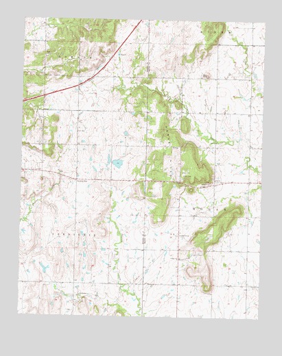
Osage Hills, OK USGS Topographic Map
Click on map above to begin viewing in our Map Viewer.

This topographic map contains these locations and features:
Feature Name Type Latitude Longitude GNIS ID View Map
Bald KnobSummitN36.3518°W95.4041°1089807View Map
Claremore Regional AirportAirportN36.2924°W95.4770°1102408View Map
Harmony StarPopulated PlaceN36.3076°W95.4711°1100478View Map
Northeast Technology Center PryorSchoolN36.3091°W95.4251°1790441View Map
Osage - Pleasant View Volunteer Fire DepartmentBuildingN36.3053°W95.4008°2656903View Map
Osage ChurchChurchN36.3237°W95.3991°1096310View Map
Osage Elementary SchoolSchoolN36.3078°W95.3985°1096328View Map
Osage HillsRangeN36.3209°W95.4228°1096318View Map
Pleasant View ChurchChurchN36.2748°W95.4166°1096776View Map
Tri - District Fire Protection District Main StationBuildingN36.3167°W95.4729°2656862View Map
Union ChapelChurchN36.3276°W95.4714°1099158View Map
Vann CemeteryCemeteryN36.3065°W95.4030°1099225View Map

Note: Coordinates in the location and feature list above are referenced to NAD83 datum.


Copyright (C) 2008-2025 Ryan Niemi / Sunset Dynamics ... All Rights Reserved