TopoQuest Logo
Do you find TopoQuest useful?
Help keep TopoQuest running and adding new maps/features by donating!
Bitcoin:  19c7KJd3qBynnjoSw5npx9KScwjBe4ifkT
Litecoin:  LXs6TkuXGGXo1vDsWCkWVdjQX94eUKd6ui
Home View Maps Find Maps Find Places Resources & Links


Bushyhead, Oklahoma Topographic Map

USGS Map Title: Bushyhead, OK
USGS Map MRC: 36095D4
DRG (GeoTIFF) Download: o36095d4.tif


Neighboring USGS Topographic Map Quads:


  Winganon, OK  
36095E5
 

  Chelsea, OK  
36095E4
 

  White Oak, OK  
36095E3
 

  Foyil, OK  
36095D5
 

  Bushyhead, OK  
36095D4
 

  Adair, OK  
36095D3
 

  Claremore, OK  
36095C5
 

  Osage Hills, OK  
36095C4
 

  Pryor, OK  
36095C3


Map MRC Location:

N37°
W96°
N37°
W95°
H8 H7 H6 H5 H4 H3 H2 H1
G8 G7 G6 G5 G4 G3 G2 G1
F8 F7 F6 F5 F4 F3 F2 F1
E8 E7 E6 E5 E4 E3 E2 E1
D8 D7 D6 D5 D4 D3 D2 D1
C8 C7 C6 C5 C4 C3 C2 C1
B8 B7 B6 B5 B4 B3 B2 B1
A8 A7 A6 A5 A4 A3 A2 A1
N36°
W96°
N36°
W95°

Bushyhead, OK USGS 1:24K Topographic Map Preview:
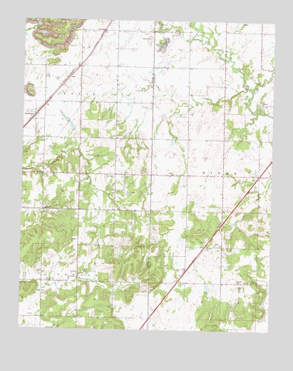
Bushyhead, OK USGS Topographic Map
Click on map above to begin viewing in our Map Viewer.

This topographic map contains these locations and features:
Feature Name Type Latitude Longitude GNIS ID View Map
Beck CemeteryCemeteryN36.4954°W95.4769°1089953View Map
Bethel ChurchChurchN36.4379°W95.4894°1090053View Map
Bethlehem ChurchChurchN36.4665°W95.3800°1090069View Map
Bethlehem Lutheran CemeteryCemeteryN36.4659°W95.3805°2712521View Map
BushyheadPopulated PlaceN36.4615°W95.4941°1100252View Map
Dawes CemeteryCemeteryN36.4928°W95.4376°1091959View Map
Diamondhead - Lone Chapel Fire and RescueBuildingN36.4072°W95.3779°2657032View Map
Diver CreekStreamN36.4734°W95.3883°1092097View Map
Foyil Fire Protection District Station 2BuildingN36.4758°W95.4719°2657056View Map
Good Hope ChurchChurchN36.4376°W95.4566°1093244View Map
HislePopulated PlaceN36.4768°W95.4764°1100499View Map
HowardPopulated PlaceN36.4954°W95.4589°1100510View Map
Little Pryor CreekStreamN36.4720°W95.3853°1094803View Map
Lone ChapelChurchN36.3951°W95.3852°1094893View Map
Lone Chapel CemeteryCemeteryN36.3914°W95.3821°1094894View Map
Oknoname 131010 DamDamN36.4551°W95.4753°1755282View Map
Oknoname 131010 ReservoirReservoirN36.4569°W95.4758°1755283View Map
Polone DamDamN36.3918°W95.4069°1751322View Map
Polone ReservoirReservoirN36.3922°W95.4066°1751323View Map
Washington CemeteryCemeteryN36.3951°W95.4866°1099385View Map
Washington ChurchChurchN36.3979°W95.4705°1099386View Map

Note: Coordinates in the location and feature list above are referenced to NAD83 datum.


Copyright (C) 2008-2024 Ryan Niemi / Sunset Dynamics ... All Rights Reserved