TopoQuest Logo
Do you find TopoQuest useful?
Help keep TopoQuest running and adding new maps/features by donating!
Bitcoin:  19c7KJd3qBynnjoSw5npx9KScwjBe4ifkT
Litecoin:  LXs6TkuXGGXo1vDsWCkWVdjQX94eUKd6ui
Home View Maps Find Maps Find Places Resources & Links


Ossineke, Michigan Topographic Map

USGS Map Title: Ossineke, MI
USGS Map MRC: 44083H4
DRG (GeoTIFF) Download: o44083h4.tif


Neighboring USGS Topographic Map Quads:


  Lake Winyah, MI  
45083A5
 

  Alpena, MI  
45083A4
 

  North Point, MI  
45083A3
 

  Big Ravine Creek, MI  
44083H5
 

  Ossineke, MI  
44083H4
 

  South Point, MI  
44083H3
 

  Hubbard Lake, MI  
44083G5
 

  Spruce, MI  
44083G4
 

  Black River, MI  
44083G3


Map MRC Location:

N45°
W84°
N45°
W83°
H8 H7 H6 H5 H4 H3 H2 H1
G8 G7 G6 G5 G4 G3 G2 G1
F8 F7 F6 F5 F4 F3 F2 F1
E8 E7 E6 E5 E4 E3 E2 E1
D8 D7 D6 D5 D4 D3 D2 D1
C8 C7 C6 C5 C4 C3 C2 C1
B8 B7 B6 B5 B4 B3 B2 B1
A8 A7 A6 A5 A4 A3 A2 A1
N44°
W84°
N44°
W83°

Ossineke, MI USGS 1:24K Topographic Map Preview:
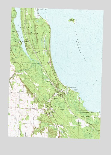
Ossineke, MI USGS Topographic Map
Click on map above to begin viewing in our Map Viewer.

This topographic map contains these locations and features:
Feature Name Type Latitude Longitude GNIS ID View Map
Alcona Health CenterHospitalN44.9086°W83.4425°2492416View Map
Berlinski CreekStreamN44.9500°W83.4703°621161View Map
Cranberry CreekStreamN44.9592°W83.4455°623961View Map
Devils LakeLakeN44.9853°W83.4886°1623171View Map
Devils RiverStreamN44.9261°W83.4208°624610View Map
German CemeteryCemeteryN44.9175°W83.4830°626753View Map
Good Shepherd Lutheran ChurchChurchN44.8981°W83.4406°2492414View Map
Hardwood PointCapeN44.9011°W83.3752°627788View Map
North Branch Devils RiverStreamN44.9189°W83.4341°633506View Map
Northland Baptist ChurchChurchN44.9478°W83.4453°2492420View Map
OssinekePopulated PlaceN44.9022°W83.4425°634144View Map
Ossineke Census Designated PlaceCensusN44.9072°W83.4288°2393175View Map
Ossineke Forest CampgroundLocaleN44.9200°W83.4105°634145View Map
Ossineke ParkParkN44.9158°W83.4378°634146View Map
Ossineke Post OfficePost OfficeN44.9036°W83.4431°2492417View Map
Ossineke StationLocaleN44.9197°W83.4300°2492415View Map
Ossineke United Methodist ChurchChurchN44.8875°W83.4317°2492418View Map
Precore CreekStreamN44.9592°W83.4828°635417View Map
Riverview Estates Mobile Home ParkPopulated PlaceN44.8900°W83.4347°2492419View Map
Saint Catherine ChurchChurchN44.9033°W83.4900°636586View Map
Saint Catherine's CemeteryCemeteryN44.9047°W83.4894°2492467View Map
Sanborn Country ParkParkN44.9242°W83.4180°637158View Map
Sanborn SchoolSchoolN44.8997°W83.4428°2492421View Map
Sanborn Township CemeteryCemeteryN44.9211°W83.4339°1618606View Map
Sanborn Township Fire DepartmentBuildingN44.9016°W83.4421°2626966View Map
South Branch Devils RiverStreamN44.9189°W83.4341°1621685View Map
Sulphur IslandIslandN44.9889°W83.4166°639049View Map
Township of SanbornCivilN44.8967°W83.4364°1627038View Map

Note: Coordinates in the location and feature list above are referenced to NAD83 datum.


Copyright (C) 2008-2025 Ryan Niemi / Sunset Dynamics ... All Rights Reserved