TopoQuest Logo
Do you find TopoQuest useful?
Help keep TopoQuest running and adding new maps/features by donating!
Bitcoin:  19c7KJd3qBynnjoSw5npx9KScwjBe4ifkT
Litecoin:  LXs6TkuXGGXo1vDsWCkWVdjQX94eUKd6ui
Home View Maps Find Maps Find Places Resources & Links


Ossipee Lake, New Hampshire Topographic Map

USGS Map Title: Ossipee Lake, NH
USGS Map MRC: 43071G2
DRG (GeoTIFF) Download: o43071g2.tif


Neighboring USGS Topographic Map Quads:


  Mount Chocorua, NH  
43071H3
 

  Silver Lake, NH  
43071H2
 

  Conway, NH  
43071H1
 

  Tamworth, NH  
43071G3
 

  Ossipee Lake, NH  
43071G2
 

  Freedom, NH  
43071G1
 

  Melvin Village, NH  
43071F3
 

  Tuftonboro, NH  
43071F2
 

  Ossipee, NH  
43071F1


Map MRC Location:

N44°
W72°
N44°
W71°
H8 H7 H6 H5 H4 H3 H2 H1
G8 G7 G6 G5 G4 G3 G2 G1
F8 F7 F6 F5 F4 F3 F2 F1
E8 E7 E6 E5 E4 E3 E2 E1
D8 D7 D6 D5 D4 D3 D2 D1
C8 C7 C6 C5 C4 C3 C2 C1
B8 B7 B6 B5 B4 B3 B2 B1
A8 A7 A6 A5 A4 A3 A2 A1
N43°
W72°
N43°
W71°

Ossipee Lake, NH USGS 1:24K Topographic Map Preview:
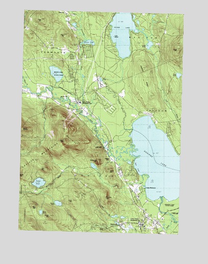
Ossipee Lake, NH USGS Topographic Map
Click on map above to begin viewing in our Map Viewer.

This topographic map contains these locations and features:
Feature Name Type Latitude Longitude GNIS ID View Map
Bean MountainSummitN43.7656°W71.2376°865431View Map
Bean PondLakeN43.7607°W71.2323°865432View Map
Bearcamp RiverStreamN43.7973°W71.1567°871469View Map
Beech RiverStreamN43.7573°W71.1281°865521View Map
Camp CalumetLocaleN43.8023°W71.1637°1915890View Map
Camp CodyLocaleN43.8154°W71.1584°1915891View Map
Camp WeetamoeLocaleN43.7781°W71.1526°865957View Map
Camp WinnemontLocaleN43.8073°W71.1631°1915896View Map
Campground Number 1LocaleN43.8326°W71.2192°1915897View Map
Campground Number 2LocaleN43.8340°W71.2140°1915898View Map
Campground Number 3LocaleN43.8356°W71.2140°1915899View Map
Carroll CountyCivilN43.8738°W71.2030°873175View Map
Center OssipeePopulated PlaceN43.7551°W71.1520°866082View Map
Center Ossipee Census Designated PlaceCensusN43.7543°W71.1514°2629719View Map
Center Ossipee Fire and RescueBuildingN43.7561°W71.1521°2605178View Map
Center Ossipee Post OfficePost OfficeN43.7542°W71.1525°1915906View Map
Chocorua RiverStreamN43.8170°W71.1953°871678View Map
Conner PondLakeN43.7774°W71.2344°866308View Map
Cooks PondLakeN43.8570°W71.1509°866324View Map
Dan Hole River DamDamN43.7534°W71.1712°1775782View Map
Dan Hole River ReservoirReservoirN43.7534°W71.1712°1775783View Map
Deer BrookStreamN43.8734°W71.2042°871775View Map
Deer Cap Ski Touring CenterLocaleN43.7526°W71.1384°1915933View Map
Deer CoveBayN43.7898°W71.1570°866526View Map
Dorrs CornerPopulated PlaceN43.7526°W71.1790°866615View Map
Folsom BrookStreamN43.7637°W71.1403°866913View Map
Grant PeakSummitN43.8012°W71.2151°867179View Map
Indian Mound Golf CourseLocaleN43.7737°W71.1578°1915988View Map
Jackman RidgeRidgeN43.8334°W71.1512°867744View Map
Knox MountainSummitN43.7684°W71.2070°867912View Map
Lifestar Emergency Medical ServiceBuildingN43.8262°W71.2044°2658859View Map
Lily PondLakeN43.8367°W71.1881°868015View Map
Loon IslandIslandN43.8626°W71.1803°868161View Map
Lovell RiverStreamN43.7837°W71.1545°868189View Map
Meaders HeliportAirportN43.7929°W71.1767°873380View Map
Mill BrookStreamN43.8362°W71.2481°872300View Map
Moody PondLakeN43.7659°W71.2190°868527View Map
Moores PondLakeN43.8576°W71.1985°868540View Map
MoultonvillePopulated PlaceN43.7545°W71.1698°868584View Map
Mount Whittier Ski AreaLocaleN43.8081°W71.2140°1916055View Map
New Hampshire State Police Troop EBuildingN43.8292°W71.2087°2753008View Map
Nickerson MountainsRidgeN43.8009°W71.2103°868737View Map
Oak MountainSummitN43.7856°W71.2301°868878View Map
Ossipee Central SchoolSchoolN43.7539°W71.1511°1916076View Map
Ossipee LakeLakeN43.7928°W71.1312°868936View Map
Ossipee Police DeptBuildingN43.7546°W71.1539°2752920View Map
Ossipee ValleyPopulated PlaceN43.7920°W71.1776°868941View Map
Page HillSummitN43.8692°W71.2348°868978View Map
Pine RiverStreamN43.7720°W71.1401°869201View Map
Raccoon MountainRidgeN43.7692°W71.1831°869422View Map
Rattlesnake MountainSummitN43.7909°W71.1892°869452View Map
Ryan HillSummitN43.8606°W71.2187°869655View Map
Saint Andrews ChurchChurchN43.8240°W71.2081°1916100View Map
Sheep MountainSummitN43.7856°W71.1806°869894View Map
Silver LakeReservoirN43.8672°W71.1722°872664View Map
Silver Lake DamDamN43.8484°W71.1712°1775267View Map
Stacy MountainSummitN43.8548°W71.1292°870131View Map
Stony BrookStreamN43.8281°W71.2376°870206View Map
Swift RiverStreamN43.8315°W71.2470°870317View Map
Thurley MountainSummitN43.7590°W71.2256°870432View Map
Trout PondLakeN43.8403°W71.1274°870509View Map
West BranchStreamN43.8087°W71.1620°870753View Map
West OssipeePopulated PlaceN43.8248°W71.2048°870784View Map
West Ossipee Fire and Rescue DepartmentBuildingN43.8226°W71.2045°2605035View Map
West Ossipee Post OfficePost OfficeN43.8203°W71.2001°1916158View Map
White LakeLakeN43.8396°W71.2231°1916159View Map
White Lake Camping GroundLocaleN43.8342°W71.2076°1916160View Map
White Lake State ParkParkN43.8409°W71.2223°870844View Map
White Mountain Gateway Airport (historical)AirportN43.8204°W71.1334°873396View Map
Whittier BridgeBridgeN43.8223°W71.2120°1916162View Map
Windsock Village AirportAirportN43.8212°W71.1757°873451View Map

Note: Coordinates in the location and feature list above are referenced to NAD83 datum.


Copyright (C) 2008-2024 Ryan Niemi / Sunset Dynamics ... All Rights Reserved