TopoQuest Logo
Do you find TopoQuest useful?
Help keep TopoQuest running and adding new maps/features by donating!
Bitcoin:  19c7KJd3qBynnjoSw5npx9KScwjBe4ifkT
Litecoin:  LXs6TkuXGGXo1vDsWCkWVdjQX94eUKd6ui
Home View Maps Find Maps Find Places Resources & Links


Conway, New Hampshire Topographic Map

USGS Map Title: Conway, NH
USGS Map MRC: 43071H1
DRG (GeoTIFF) Download: o43071h1.tif


Neighboring USGS Topographic Map Quads:


  North Conway West, NH  
44071A2
 

  North Conway East, NH  
44071A1
 

  Fryeburg, ME  
44070A8
 

  Silver Lake, NH  
43071H2
 

  Conway, NH  
43071H1
 

  Brownfield, ME  
43070H8
 

  Ossipee Lake, NH  
43071G2
 

  Freedom, NH  
43071G1
 

  Kezar Falls, ME  
43070G8


Map MRC Location:

N44°
W72°
N44°
W71°
H8 H7 H6 H5 H4 H3 H2 H1
G8 G7 G6 G5 G4 G3 G2 G1
F8 F7 F6 F5 F4 F3 F2 F1
E8 E7 E6 E5 E4 E3 E2 E1
D8 D7 D6 D5 D4 D3 D2 D1
C8 C7 C6 C5 C4 C3 C2 C1
B8 B7 B6 B5 B4 B3 B2 B1
A8 A7 A6 A5 A4 A3 A2 A1
N43°
W72°
N43°
W71°

Conway, NH USGS 1:24K Topographic Map Preview:
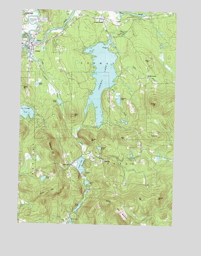
Conway, NH USGS Topographic Map
Click on map above to begin viewing in our Map Viewer.

This topographic map contains these locations and features:
Feature Name Type Latitude Longitude GNIS ID View Map
Atkinson MountainSummitN43.9259°W71.0687°871409View Map
Birch HillSummitN43.9267°W71.0420°871507View Map
Cady Memorial SchoolSchoolN43.9947°W71.0535°2500249View Map
Center ConwayPopulated PlaceN43.9948°W71.0609°871651View Map
Center Conway CemeteryCemeteryN43.9937°W71.0547°2741121View Map
Center Conway Fire and RescueBuildingN43.9952°W71.0624°2605149View Map
Center Conway Post OfficePost OfficeN43.9935°W71.0523°1915904View Map
Clark BrookStreamN43.9626°W71.0481°871685View Map
ConwayPopulated PlaceN43.9792°W71.1203°871721View Map
Conway Area Academic CenterSchoolN43.9920°W71.1102°2500247View Map
Conway Census Designated PlaceCensusN43.9845°W71.1181°2378057View Map
Conway Crossing Factory Stores Shopping CenterLocaleN43.9853°W71.1126°1915921View Map
Conway Elementary SchoolSchoolN43.9800°W71.1240°1915922View Map
Conway LakeReservoirN43.9621°W71.0592°871722View Map
Conway Lake DamDamN43.9851°W71.0528°1775327View Map
Conway Public LibraryBuildingN43.9787°W71.1173°1915924View Map
Conway Village CemeteryCemeteryN43.9824°W71.1211°871724View Map
Conway Village Congregational ChurchChurchN43.9790°W71.1226°1915926View Map
Conway Village Fire DepartmentBuildingN43.9782°W71.1225°2605117View Map
Crown HillSummitN43.9273°W71.0137°871748View Map
Crystal LakeLakeN43.9095°W71.0767°871751View Map
Davis HillSummitN43.9715°W71.0215°871766View Map
Dollof PondLakeN43.9466°W71.0928°871789View Map
Dundee HillSummitN43.9467°W71.0131°871812View Map
Eaton CenterPopulated PlaceN43.9092°W71.0837°871845View Map
Eaton Center Post OfficePost OfficeN43.9116°W71.0796°1915948View Map
Eaton SchoolSchoolN43.9137°W71.0678°871846View Map
Foss MountainRidgeN43.8804°W71.0373°871899View Map
Grove BrookStreamN43.9662°W71.1109°871977View Map
Hatch PondLakeN43.8993°W71.0693°872020View Map
Hatches OrchardLocaleN43.9578°W71.0169°2611143View Map
Kent HillSummitN43.8915°W71.0237°872134View Map
Labrador PondLakeN43.9482°W71.0450°872148View Map
Libby MountainSummitN43.9384°W71.0842°872165View Map
Long PondLakeN43.8849°W71.0759°872213View Map
Loud PondLakeN43.9014°W71.1044°872223View Map
Lyman MountainRidgeN43.8937°W71.1003°872235View Map
Manson HillSummitN43.8884°W71.0498°872252View Map
Page Randall BrookStreamN43.9776°W71.1242°872451View Map
Pea Porridge PondLakeN43.9400°W71.1198°872467View Map
Pequawket Power Company DamDamN43.9784°W71.1212°1775333View Map
Pickerel PondLakeN43.9051°W71.0720°872493View Map
Pine Tree Elementary SchoolSchoolN43.9899°W71.0551°1916087View Map
Potter CemeteryCemeteryN43.9439°W71.0506°872523View Map
Roberts PondLakeN43.9198°W71.0597°872577View Map
Rockhouse MountainRidgeN43.9184°W71.1017°872578View Map
Saco River Covered BridgeBridgeN43.9831°W71.1003°1916099View Map
Saint Margaret Anglican ChurchChurchN43.9762°W71.1170°1916102View Map
Snake PondLakeN43.9570°W71.1145°872685View Map
Snow BrookStreamN43.9978°W71.0465°872687View Map
Snowvillage Ski Touring CenterLocaleN43.8929°W71.0476°1916114View Map
SnowvillePopulated PlaceN43.9126°W71.0578°872691View Map
South ConwayPopulated PlaceN43.9631°W71.0226°872700View Map
Stewart HillSummitN43.8912°W71.0126°872735View Map
Swift RiverStreamN43.9840°W71.1217°872768View Map
Swift River BridgeBridgeN43.9851°W71.1170°1916127View Map
Town of EatonCivilN43.9026°W71.0483°873587View Map
Valley Christian ChurchChurchN43.9817°W71.1009°1916146View Map
WBNC-AM (Conway)TowerN43.9798°W71.1103°872987View Map
Willey BrookStreamN43.9553°W71.0548°872948View Map
WMLY-FM (Conway)TowerN43.9317°W71.0956°873334View Map

Note: Coordinates in the location and feature list above are referenced to NAD83 datum.


Copyright (C) 2008-2024 Ryan Niemi / Sunset Dynamics ... All Rights Reserved