TopoQuest Logo
Do you find TopoQuest useful?
Help keep TopoQuest running and adding new maps/features by donating!
Bitcoin:  19c7KJd3qBynnjoSw5npx9KScwjBe4ifkT
Litecoin:  LXs6TkuXGGXo1vDsWCkWVdjQX94eUKd6ui
Home View Maps Find Maps Find Places Resources & Links


Bennington, Kansas Topographic Map

USGS Map Title: Bennington, KS
USGS Map MRC: 39097A5
DRG (GeoTIFF) Download: o39097a5.tif


Neighboring USGS Topographic Map Quads:


  Minneapolis North, KS  
39097B6
 

  Wells, KS  
39097B5
 

  Manchester NW, KS  
39097B4
 

  Minneapolis South, KS  
39097A6
 

  Bennington, KS  
39097A5
 

  Vine Creek, KS  
39097A4
 

  Trenton, KS  
38097H6
 

  New Cambria, KS  
38097H5
 

  Niles, KS  
38097H4


Map MRC Location:

N40°
W98°
N40°
W97°
H8 H7 H6 H5 H4 H3 H2 H1
G8 G7 G6 G5 G4 G3 G2 G1
F8 F7 F6 F5 F4 F3 F2 F1
E8 E7 E6 E5 E4 E3 E2 E1
D8 D7 D6 D5 D4 D3 D2 D1
C8 C7 C6 C5 C4 C3 C2 C1
B8 B7 B6 B5 B4 B3 B2 B1
A8 A7 A6 A5 A4 A3 A2 A1
N39°
W98°
N39°
W97°

Bennington, KS USGS 1:24K Topographic Map Preview:
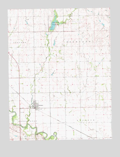
Bennington, KS USGS Topographic Map
Click on map above to begin viewing in our Map Viewer.

This topographic map contains these locations and features:
Feature Name Type Latitude Longitude GNIS ID View Map
Alderson AirportAirportN39.0347°W97.5800°2651022View Map
Antelope CreekStreamN39.0283°W97.6248°476464View Map
BenningtonPopulated PlaceN39.0306°W97.5942°476467View Map
Bennington Ambulance ServiceBuildingN39.0312°W97.5938°2696580View Map
Bennington Bible ChurchChurchN39.0397°W97.5927°2690823View Map
Bennington CemeteryCemeteryN39.0380°W97.5939°2739688View Map
Bennington Elementary SchoolSchoolN39.0325°W97.5970°2497350View Map
Bennington High SchoolSchoolN39.0328°W97.5966°480374View Map
Bennington Wastewater PlantLocaleN39.0252°W97.6016°2692139View Map
Berkley Airport (historical)AirportN39.0486°W97.5906°481445View Map
City of BenningtonCivilN39.0333°W97.5931°2394136View Map
Episcopal Church of the TransfigurationChurchN39.0328°W97.5934°2690835View Map
Ottawa County Fire District 4 BenningtonBuildingN39.0309°W97.5939°2111704View Map
Ottawa County State Lake DamDamN39.1111°W97.5670°479900View Map
Ottawa County State ParkParkN39.1111°W97.5670°476465View Map
Ottawa State Fishing Lake and Wildlife AreaParkN39.1111°W97.5670°479774View Map
Sand CreekStreamN39.0156°W97.6036°476469View Map
State LakeReservoirN39.1095°W97.5697°476466View Map
Team Marketing Alliance Grain Elevator Number 41LocaleN39.0293°W97.5919°2695246View Map
Township of BuckeyeCivilN39.0016°W97.5289°476468View Map
Township of RichlandCivilN39.0886°W97.5382°476288View Map
United Church of BenningtonChurchN39.0324°W97.5933°2690869View Map

Note: Coordinates in the location and feature list above are referenced to NAD83 datum.


Copyright (C) 2008-2025 Ryan Niemi / Sunset Dynamics ... All Rights Reserved