TopoQuest Logo
Do you find TopoQuest useful?
Help keep TopoQuest running and adding new maps/features by donating!
Bitcoin:  19c7KJd3qBynnjoSw5npx9KScwjBe4ifkT
Litecoin:  LXs6TkuXGGXo1vDsWCkWVdjQX94eUKd6ui
Home View Maps Find Maps Find Places Resources & Links


Packton, Louisiana Topographic Map

USGS Map Title: Packton, LA
USGS Map MRC: 31092G5
DRG (GeoTIFF) Download: o31092g5.tif


Neighboring USGS Topographic Map Quads:


  Winnfield West, LA  
31092H6
 

  Winnfield East, LA  
31092H5
 

  Flat Creek, LA  
31092H4
 

  Atlanta, LA  
31092G6
 

  Packton, LA  
31092G5
 

  Georgetown, LA  
31092G4
 

  Savage Creek, LA  
31092F6
 

  Williana, LA  
31092F5
 

  Mudville, LA  
31092F4


Map MRC Location:

N32°
W93°
N32°
W92°
H8 H7 H6 H5 H4 H3 H2 H1
G8 G7 G6 G5 G4 G3 G2 G1
F8 F7 F6 F5 F4 F3 F2 F1
E8 E7 E6 E5 E4 E3 E2 E1
D8 D7 D6 D5 D4 D3 D2 D1
C8 C7 C6 C5 C4 C3 C2 C1
B8 B7 B6 B5 B4 B3 B2 B1
A8 A7 A6 A5 A4 A3 A2 A1
N31°
W93°
N31°
W92°

Packton, LA USGS 1:24K Topographic Map Preview:
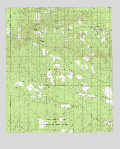
Packton, LA USGS Topographic Map
Click on map above to begin viewing in our Map Viewer.

This topographic map contains these locations and features:
Feature Name Type Latitude Longitude GNIS ID View Map
Boggy BranchStreamN31.7718°W92.5310°547115View Map
Bucker CreekStreamN31.8079°W92.5332°547144View Map
Caney BranchStreamN31.7874°W92.5960°547186View Map
Caskey BranchStreamN31.7854°W92.5790°547196View Map
Corinth CemeteryCemeteryN31.7966°W92.5418°547249View Map
Cox BranchStreamN31.8399°W92.5243°547258View Map
Farmer BranchStreamN31.7613°W92.5176°547352View Map
Fourmile BranchStreamN31.7610°W92.5038°547373View Map
Hurricane CreekStreamN31.8607°W92.6235°547496View Map
Iatt Lookout Tower (historical)TowerN31.8468°W92.5996°549149View Map
Jordan HillPopulated PlaceN31.8541°W92.5226°547531View Map
Jordan HillSummitN31.8607°W92.5282°547532View Map
Jordan Hill Census Designated PlaceCensusN31.8591°W92.5156°2586686View Map
Jordon Hill CemeteryCemeteryN31.8475°W92.5208°547533View Map
Kenny BranchStreamN31.7785°W92.5532°547540View Map
Killan CreekStreamN31.7971°W92.5018°547546View Map
Latt Lookout TowerTowerN31.8463°W92.5999°558793View Map
Little Dry CreekStreamN31.8685°W92.5457°547602View Map
Melton CemeteryCemeteryN31.8410°W92.5971°547680View Map
Mills BranchStreamN31.7816°W92.5307°547721View Map
MoorePopulated PlaceN31.8413°W92.5843°547731View Map
New MoorePopulated PlaceN31.8529°W92.5885°547772View Map
PacktonPopulated PlaceN31.7977°W92.5768°547810View Map
Parish Governing Authority District 7CivilN31.8310°W92.5564°1930219View Map
Piney Woods BranchStreamN31.7757°W92.5479°547849View Map
Pleasant Hill (historical)Populated PlaceN31.8293°W92.5696°549172View Map
Pleasant Hill CemeteryCemeteryN31.8290°W92.5604°547856View Map
Tunica (historical)Populated PlaceN31.8627°W92.5585°549185View Map
Tyson CemeteryCemeteryN31.7904°W92.6054°548265View Map
Ward NineCivilN31.8585°W92.5485°545295View Map

Note: Coordinates in the location and feature list above are referenced to NAD83 datum.


Copyright (C) 2008-2025 Ryan Niemi / Sunset Dynamics ... All Rights Reserved