TopoQuest Logo
Do you find TopoQuest useful?
Help keep TopoQuest running and adding new maps/features by donating!
Bitcoin:  19c7KJd3qBynnjoSw5npx9KScwjBe4ifkT
Litecoin:  LXs6TkuXGGXo1vDsWCkWVdjQX94eUKd6ui
Home View Maps Find Maps Find Places Resources & Links


Page, Arizona Topographic Map

USGS Map Title: Page, AZ
USGS Map MRC: 36111H4
DRG (GeoTIFF) Download: o36111h4.tif


Neighboring USGS Topographic Map Quads:


  Lone Rock, UT  
37111A5
 

  Warm Creek Bay, UT  
37111A4
 

  Gunsight Butte, UT  
37111A3
 

  Ferry Swale, AZ  
36111H5
 

  Page, AZ  
36111H4
 

  Wild Horse Mesa, AZ  
36111H3
 

  Lees Ferry, AZ  
36111G5
 

  White Dome, AZ  
36111G4
 

  Leche-e Rock, AZ  
36111G3


Map MRC Location:

N37°
W112°
N37°
W111°
H8 H7 H6 H5 H4 H3 H2 H1
G8 G7 G6 G5 G4 G3 G2 G1
F8 F7 F6 F5 F4 F3 F2 F1
E8 E7 E6 E5 E4 E3 E2 E1
D8 D7 D6 D5 D4 D3 D2 D1
C8 C7 C6 C5 C4 C3 C2 C1
B8 B7 B6 B5 B4 B3 B2 B1
A8 A7 A6 A5 A4 A3 A2 A1
N36°
W112°
N36°
W111°

Page, AZ USGS 1:24K Topographic Map Preview:
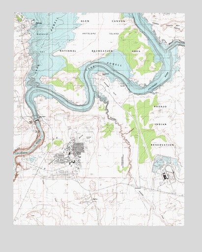
Page, AZ USGS Topographic Map
Click on map above to begin viewing in our Map Viewer.

This topographic map contains these locations and features:
Feature Name Type Latitude Longitude GNIS ID View Map
Antelope CanyonValleyN36.9528°W111.4413°20631View Map
Antelope CreekStreamN36.9528°W111.4429°668View Map
Antelope IslandIslandN36.9833°W111.4340°20632View Map
Arizona State Inspection StationLocaleN36.9494°W111.4985°43386View Map
Beehive RockPillarN36.9355°W111.4879°1197View Map
Chapman's Mobile Home ResortPopulated PlaceN36.9108°W111.4519°2670385View Map
Coconino Community CollegeSchoolN36.9084°W111.4625°2543626View Map
Coconino County Sheriff's Office PageBuildingN36.9092°W111.4839°2751593View Map
Cummings MesaSummitN36.9917°W111.3807°3641View Map
Desert View Elementary SchoolSchoolN36.9201°W111.4647°2543696View Map
Emergency Medical HeliportAirportN36.9169°W111.4643°45430View Map
Faith Bible ChapelChurchN36.9041°W111.4698°2670900View Map
First Assembly of GodChurchN36.9143°W111.4528°2670924View Map
First Baptist ChurchChurchN36.9146°W111.4546°2670940View Map
Glen Canyon DamDamN36.9375°W111.4843°5056View Map
Glen Canyon Dam Visitor CenterBuildingN36.9347°W111.4846°20771View Map
Glen Canyon Generating StationLocaleN36.9125°W111.3854°20772View Map
Glen Canyon SubstationLocaleN36.9319°W111.4854°20773View Map
Immaculate Heart of Mary Catholic ChurchChurchN36.9098°W111.4584°2671175View Map
Jack Doland FieldParkN36.9083°W111.4535°20823View Map
John C Page ParkParkN36.9139°W111.4563°20832View Map
Kingdom Hall of Jehovahs WitnessesChurchN36.9128°W111.4520°2671490View Map
KPGE-AM (Page)TowerN36.9064°W111.4596°43398View Map
KXAZ-FM (Page)TowerN36.9064°W111.4596°43400View Map
Lake Powell AcademySchoolN36.9037°W111.4585°2543519View Map
Lake Powell Church of the NazareneChurchN36.9145°W111.4538°2671528View Map
Lake Powell Medical CenterBuildingN36.9184°W111.4627°2670417View Map
Lake Powell National Golf CourseLocaleN36.9163°W111.4722°2669907View Map
Lake View Elementary SchoolSchoolN36.9311°W111.4594°2543672View Map
Manson MesaSummitN36.9105°W111.4557°7652View Map
Navajo CanyonValleyN36.9753°W111.3882°44875View Map
Navajo CreekStreamN36.9739°W111.3896°8530View Map
PagePopulated PlaceN36.9147°W111.4558°9110View Map
Page Community United Methodist ChurchChurchN36.9137°W111.4522°2671675View Map
Page Elementary SchoolSchoolN36.9125°W111.4590°20940View Map
Page Fire DepartmentBuildingN36.9078°W111.4558°2672379View Map
Page Fire Department - AirportBuildingN36.9253°W111.4525°2775458View Map
Page High SchoolSchoolN36.9121°W111.4568°20941View Map
Page HospitalHospitalN36.9177°W111.4637°2667628View Map
Page Lake Powell Mobile Home VillagePopulated PlaceN36.9051°W111.4639°2669761View Map
Page Middle SchoolSchoolN36.9150°W111.4512°2543707View Map
Page Municipal AirportAirportN36.9251°W111.4492°45431View Map
Page Police DepartmentBuildingN36.9080°W111.4559°2672283View Map
Page Post OfficePost OfficeN36.9159°W111.4617°2670495View Map
Page Public LibraryBuildingN36.9085°W111.4628°2669452View Map
Page SubstationLocaleN36.9047°W111.4763°20943View Map
Rim View Trailer VillagePopulated PlaceN36.9238°W111.4605°2669835View Map
Saint David's Episcopal ChurchChurchN36.9112°W111.4542°2671279View Map
Sentinel RockPillarN36.9555°W111.4852°11081View Map
The Church of Jesus Christ of Latter Day SaintsChurchN36.9278°W111.4599°2671355View Map
The Church of Jesus Christ of Latter Day SaintsChurchN36.9122°W111.4527°2671886View Map
WahweapPopulated PlaceN36.9967°W111.4902°25256View Map
Wahweap Airport (historical)AirportN36.9889°W111.4971°21108View Map
Wahweap Lodge and MarinaLocaleN36.9561°W111.4882°21109View Map

Note: Coordinates in the location and feature list above are referenced to NAD83 datum.


Copyright (C) 2008-2025 Ryan Niemi / Sunset Dynamics ... All Rights Reserved