TopoQuest Logo
Do you find TopoQuest useful?
Help keep TopoQuest running and adding new maps/features by donating!
Bitcoin:  19c7KJd3qBynnjoSw5npx9KScwjBe4ifkT
Litecoin:  LXs6TkuXGGXo1vDsWCkWVdjQX94eUKd6ui
Home View Maps Find Maps Find Places Resources & Links


Warm Creek Bay, Utah Topographic Map

USGS Map Title: Warm Creek Bay, UT
USGS Map MRC: 37111A4
DRG (GeoTIFF) Download: o37111a4.tif


Neighboring USGS Topographic Map Quads:


  Tibbet Bench, UT  
37111B5
 

  Smoky Hollow, UT  
37111B4
 

  Sit Down Bench, UT  
37111B3
 

  Lone Rock, UT  
37111A5
 

  Warm Creek Bay, UT  
37111A4
 

  Gunsight Butte, UT  
37111A3
 

  Ferry Swale, AZ  
36111H5
 

  Page, AZ  
36111H4
 

  Wild Horse Mesa, AZ  
36111H3


Map MRC Location:

N38°
W112°
N38°
W111°
H8 H7 H6 H5 H4 H3 H2 H1
G8 G7 G6 G5 G4 G3 G2 G1
F8 F7 F6 F5 F4 F3 F2 F1
E8 E7 E6 E5 E4 E3 E2 E1
D8 D7 D6 D5 D4 D3 D2 D1
C8 C7 C6 C5 C4 C3 C2 C1
B8 B7 B6 B5 B4 B3 B2 B1
A8 A7 A6 A5 A4 A3 A2 A1
N37°
W112°
N37°
W111°

Warm Creek Bay, UT USGS 1:24K Topographic Map Preview:
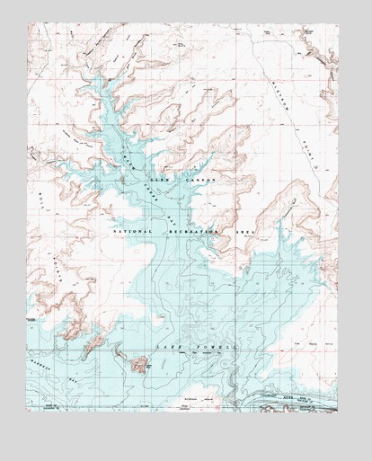
Warm Creek Bay, UT USGS Topographic Map
Click on map above to begin viewing in our Map Viewer.

This topographic map contains these locations and features:
Feature Name Type Latitude Longitude GNIS ID View Map
Castle RockPillarN37.0155°W111.4557°1426390View Map
Cottonwood WashValleyN37.0611°W111.3990°1426954View Map
Crosby CanyonValleyN37.0789°W111.4896°1450322View Map
Dewey SeepSpringN37.1220°W111.4032°1435424View Map
Gunsight SpringSpringN37.1225°W111.4060°1435638View Map
Oley KnollsSummitN37.1180°W111.4407°1436070View Map
Pasture PointCapeN37.1172°W111.4624°1436105View Map
Pasture Point CanyonValleyN37.1111°W111.4749°1436106View Map
Prickly Pear PointCapeN37.0864°W111.4807°1436176View Map
Romana BenchCapeN37.0833°W111.3924°1425094View Map
Sile Brink HollowValleyN37.1094°W111.4604°1436354View Map
Spanish Trail Crossing at Warm Creek (historical)LocaleN37.0169°W111.4149°1450509View Map
Wagon Box CanyonValleyN37.0875°W111.4452°1436580View Map
Wahweap BayBayN37.0105°W111.4957°13277View Map
Wahweap WindowArchN37.0294°W111.4965°1436581View Map
Warm CreekStreamN37.1072°W111.4721°1433953View Map
Warm Creek BayBayN37.0764°W111.4557°1433954View Map
Warm Creek Cabins (historical)LocaleN37.0408°W111.4393°1450541View Map

Note: Coordinates in the location and feature list above are referenced to NAD83 datum.


Copyright (C) 2008-2025 Ryan Niemi / Sunset Dynamics ... All Rights Reserved