TopoQuest Logo
Do you find TopoQuest useful?
Help keep TopoQuest running and adding new maps/features by donating!
Bitcoin:  19c7KJd3qBynnjoSw5npx9KScwjBe4ifkT
Litecoin:  LXs6TkuXGGXo1vDsWCkWVdjQX94eUKd6ui
Home View Maps Find Maps Find Places Resources & Links


Paicines, California Topographic Map

USGS Map Title: Paicines, CA
USGS Map MRC: 36121F3
DRG (GeoTIFF) Download: o36121f3.tif


Neighboring USGS Topographic Map Quads:


  Hollister, CA  
36121G4
 

  Tres Pinos, CA  
36121G3
 

  Quien Sabe Valley, CA  
36121G2
 

  Mount Harlan, CA  
36121F4
 

  Paicines, CA  
36121F3
 

  Cherry Peak, CA  
36121F2
 

  Gonzales, CA  
36121E4
 

  Mount Johnson, CA  
36121E3
 

  Bickmore Canyon, CA  
36121E2


Map MRC Location:

N37°
W122°
N37°
W121°
H8 H7 H6 H5 H4 H3 H2 H1
G8 G7 G6 G5 G4 G3 G2 G1
F8 F7 F6 F5 F4 F3 F2 F1
E8 E7 E6 E5 E4 E3 E2 E1
D8 D7 D6 D5 D4 D3 D2 D1
C8 C7 C6 C5 C4 C3 C2 C1
B8 B7 B6 B5 B4 B3 B2 B1
A8 A7 A6 A5 A4 A3 A2 A1
N36°
W122°
N36°
W121°

Paicines, CA USGS 1:24K Topographic Map Preview:
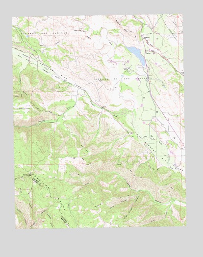
Paicines, CA USGS Topographic Map
Click on map above to begin viewing in our Map Viewer.

This topographic map contains these locations and features:
Feature Name Type Latitude Longitude GNIS ID View Map
Alvisa CanyonValleyN36.6411°W121.2880°218206View Map
Bear CanyonValleyN36.6408°W121.2591°218794View Map
Cienega De Los PaicinesCivilN36.7158°W121.2977°221107View Map
Cienega Elementary SchoolSchoolN36.7301°W121.3614°221108View Map
Cienega ValleyValleyN36.7100°W121.3349°221109View Map
Cygnet CellarsLocaleN36.7194°W121.3510°1817414View Map
Enz VineyardsLocaleN36.6938°W121.3358°1817416View Map
Grass ValleyValleyN36.7216°W121.3577°224465View Map
Harlan CreekStreamN36.7055°W121.3691°224938View Map
Indian CanyonValleyN36.7191°W121.3674°225856View Map
Matarana GulchValleyN36.6352°W121.3535°228218View Map
McPhails PeakSummitN36.6566°W121.3663°228448View Map
PaicinesPopulated PlaceN36.7286°W121.2785°1659334View Map
Paicines 1025 DamDamN36.7266°W121.2844°1664164View Map
Paicines Post OfficePost OfficeN36.7283°W121.2783°1817423View Map
Paicines RanchLocaleN36.7186°W121.2908°230234View Map
Paicines ReservoirReservoirN36.7265°W121.2849°1817424View Map
Paicines School (historical)SchoolN36.6872°W121.2719°1670170View Map
Pescadero CreekStreamN36.6941°W121.2872°264662View Map
Sulphur CanyonValleyN36.7408°W121.3291°235700View Map
Swope CanyonValleyN36.6311°W121.3608°252372View Map
Swope CanyonValleyN36.6311°W121.3599°235913View Map
Thompson CreekStreamN36.7016°W121.3208°236264View Map
Thousand Trail ResortLocaleN36.6930°W121.2969°1817427View Map
Three Troughs CanyonValleyN36.6461°W121.2855°236325View Map
Willow Grove Elementary SchoolSchoolN36.7356°W121.2797°237917View Map

Note: Coordinates in the location and feature list above are referenced to NAD83 datum.


Copyright (C) 2008-2024 Ryan Niemi / Sunset Dynamics ... All Rights Reserved