TopoQuest Logo
Do you find TopoQuest useful?
Help keep TopoQuest running and adding new maps/features by donating!
Bitcoin:  19c7KJd3qBynnjoSw5npx9KScwjBe4ifkT
Litecoin:  LXs6TkuXGGXo1vDsWCkWVdjQX94eUKd6ui
Home View Maps Find Maps Find Places Resources & Links


Benton Heights, Michigan Topographic Map

USGS Map Title: Benton Heights, MI
USGS Map MRC: 42086B4
DRG (GeoTIFF) Download: o42086b4.tif


Neighboring USGS Topographic Map Quads:


  Covert, MI  
42086C3


  Benton Heights, MI  
42086B4
 

  Coloma, MI  
42086B3
 

  Stevensville, MI  
42086A5
 

  Benton Harbor, MI  
42086A4
 

  Sodus, MI  
42086A3


Map MRC Location:

N43°
W87°
N43°
W86°
H8 H7 H6 H5 H4 H3 H2 H1
G8 G7 G6 G5 G4 G3 G2 G1
F8 F7 F6 F5 F4 F3 F2 F1
E8 E7 E6 E5 E4 E3 E2 E1
D8 D7 D6 D5 D4 D3 D2 D1
C8 C7 C6 C5 C4 C3 C2 C1
B8 B7 B6 B5 B4 B3 B2 B1
A8 A7 A6 A5 A4 A3 A2 A1
N42°
W87°
N42°
W86°

Benton Heights, MI USGS 1:24K Topographic Map Preview:
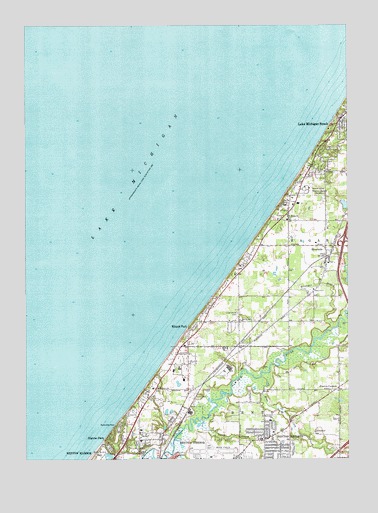
Benton Heights, MI USGS Topographic Map
Click on map above to begin viewing in our Map Viewer.

This topographic map contains these locations and features:
Feature Name Type Latitude Longitude GNIS ID View Map
Benton Charter Township Fire Department Station 2BuildingN42.1374°W86.4541°2635991View Map
Benton HeightsPopulated PlaceN42.1312°W86.4072°621145View Map
Benton Heights Church of GodChurchN42.1319°W86.4083°2373918View Map
Blue CreekStreamN42.1487°W86.4084°621624View Map
Community of Christ ChurchChurchN42.1403°W86.4550°2373916View Map
Crate Basket and Veneer Machinery MuseumBuildingN42.1833°W86.3833°2377571View Map
Eaman SchoolSchoolN42.1648°W86.4161°625102View Map
First Free Will Baptist ChurchChurchN42.1253°W86.3761°2373920View Map
General Baptist ChurchChurchN42.1439°W86.3811°2373919View Map
Granger DrainStreamN42.1623°W86.3828°627135View Map
Hagar Post Office (historical)Post OfficeN42.1722°W86.3972°2376484View Map
Higman ParkPopulated PlaceN42.1306°W86.4689°628264View Map
Interchange 4CrossingN42.1861°W86.3767°2374180View Map
Jean Klock ParkParkN42.1256°W86.4717°629225View Map
Lake Michigan Beach Census Designated PlaceCensusN42.2126°W86.3760°2393081View Map
Lake Michigan Beach Community ChurchChurchN42.2167°W86.3761°2376974View Map
Lake Shore CemeteryCemeteryN42.1670°W86.4178°629997View Map
Martindale SchoolSchoolN42.1362°W86.4059°631675View Map
Mizpah ParkPopulated PlaceN42.1625°W86.4361°632534View Map
North Shore Estates Mobile Home ParkPopulated PlaceN42.1425°W86.4525°2373976View Map
North Shore Memory GardenCemeteryN42.2025°W86.3909°633651View Map
North Shore SchoolSchoolN42.1453°W86.4509°633652View Map
Pier SchoolSchoolN42.1939°W86.3986°634824View Map
RiversidePopulated PlaceN42.1834°W86.3828°635977View Map
Riverside Post OfficePost OfficeN42.1833°W86.3828°2377513View Map
Riverside StationLocaleN42.1833°W86.3836°2377512View Map
Riverside United Methodist ChurchChurchN42.1914°W86.3828°2373913View Map
Rocky Gap ParkParkN42.1342°W86.4664°636098View Map
Saint Marys ChurchChurchN42.1948°W86.3981°636897View Map
Sand CreekStreamN42.1356°W86.4339°637167View Map
School Number 6SchoolN42.1739°W86.3884°637406View Map
Southwest Michigan Regional AirportAirportN42.1266°W86.4283°1623803View Map
Tower Hill ParkParkN42.1272°W86.3958°2373969View Map
Township of HagarCivilN42.1911°W86.3750°1626418View Map
Trinity Church of God in ChristChurchN42.1308°W86.4097°2373912View Map
Twelve CornersPopulated PlaceN42.1448°W86.3786°1615219View Map
Twelve Corners Community ChurchChurchN42.1444°W86.3789°2373922View Map
Twelve Corners Post Office (historical)Post OfficeN42.1447°W86.3786°2376453View Map
Zion Temple Church of God in ChristChurchN42.1272°W86.4444°2379266View Map

Note: Coordinates in the location and feature list above are referenced to NAD83 datum.


Copyright (C) 2008-2025 Ryan Niemi / Sunset Dynamics ... All Rights Reserved