TopoQuest Logo
Do you find TopoQuest useful?
Help keep TopoQuest running and adding new maps/features by donating!
Bitcoin:  19c7KJd3qBynnjoSw5npx9KScwjBe4ifkT
Litecoin:  LXs6TkuXGGXo1vDsWCkWVdjQX94eUKd6ui
Home View Maps Find Maps Find Places Resources & Links


Benton Lake East, Montana Topographic Map

USGS Map Title: Benton Lake East, MT
USGS Map MRC: 47111F3
DRG (GeoTIFF) Download: o47111f3.tif


Neighboring USGS Topographic Map Quads:


  Timber Coulee South, MT  
47111G4
 

  Sheep Coulee Spring, MT  
47111G3
 

  Antelope Flat, MT  
47111G2
 

  Benton Lake West, MT  
47111F4
 

  Benton Lake East, MT  
47111F3
 

  Flick Lake, MT  
47111F2
 

  Manchester, MT  
47111E4
 

  Northwest Great Falls, MT  
47111E3
 

  Northeast Great Falls, MT  
47111E2


Map MRC Location:

N48°
W112°
N48°
W111°
H8 H7 H6 H5 H4 H3 H2 H1
G8 G7 G6 G5 G4 G3 G2 G1
F8 F7 F6 F5 F4 F3 F2 F1
E8 E7 E6 E5 E4 E3 E2 E1
D8 D7 D6 D5 D4 D3 D2 D1
C8 C7 C6 C5 C4 C3 C2 C1
B8 B7 B6 B5 B4 B3 B2 B1
A8 A7 A6 A5 A4 A3 A2 A1
N47°
W112°
N47°
W111°

Benton Lake East, MT USGS 1:24K Topographic Map Preview:
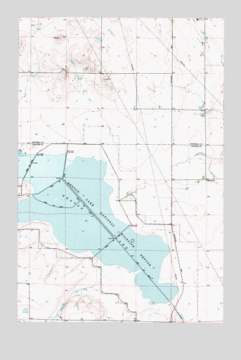
Benton Lake East, MT USGS Topographic Map
Click on map above to begin viewing in our Map Viewer.

This topographic map contains these locations and features:
Feature Name Type Latitude Longitude GNIS ID View Map
22N03E22AACB02 WellWellN47.6525°W111.3300°824329View Map
22N03E22AACC07 WellWellN47.6519°W111.3302°824320View Map
22N03E22ABCC12 WellWellN47.6513°W111.3350°824313View Map
22N03E22ABDB08 WellWellN47.6522°W111.3322°824325View Map
22N03E22ACAC13 WellWellN47.6497°W111.3327°824296View Map
22N03E22ACCD14 WellWellN47.6486°W111.3336°824293View Map
22N03E22ADAB03 WellWellN47.6508°W111.3266°824308View Map
22N03E22ADBB11 WellWellN47.6505°W111.3302°824301View Map
22N03E22ADCB04 WellWellN47.6486°W111.3300°824292View Map
22N03E22CAAA15 WellWellN47.6477°W111.3364°824289View Map
22N03E22CAAB18 WellWellN47.6477°W111.3383°824290View Map
22N03E22CACD17 WellWellN47.6450°W111.3391°824263View Map
22N03E22CDAA16 WellWellN47.6436°W111.3364°824253View Map
22N03E22DBAA09 WellWellN47.6475°W111.3314°824286View Map
22N03E22DBCA19 WellWellN47.6458°W111.3336°824270View Map
22N03E26CDCB01 WellWellN47.6272°W111.3189°824134View Map
Benton LakeLakeN47.6674°W111.3328°768712View Map
Benton Lake (historical)Populated PlaceN47.6916°W111.2925°1762284View Map
Benton Lake National Wildlife RefugeParkN47.6659°W111.3331°768713View Map
Kodak DamDamN47.7450°W111.3608°798540View Map
Lake CreekStreamN47.6922°W111.3716°802129View Map
Swall School (historical)SchoolN47.6836°W111.2616°802215View Map
Toy Box DamDamN47.7266°W111.3658°798441View Map

Note: Coordinates in the location and feature list above are referenced to NAD83 datum.


Copyright (C) 2008-2024 Ryan Niemi / Sunset Dynamics ... All Rights Reserved