TopoQuest Logo
Do you find TopoQuest useful?
Help keep TopoQuest running and adding new maps/features by donating!
Bitcoin:  19c7KJd3qBynnjoSw5npx9KScwjBe4ifkT
Litecoin:  LXs6TkuXGGXo1vDsWCkWVdjQX94eUKd6ui
Home View Maps Find Maps Find Places Resources & Links


Palisades Dam, Idaho Topographic Map

USGS Map Title: Palisades Dam, ID
USGS Map MRC: 43111C2
DRG (GeoTIFF) Download: o43111c2.tif


Neighboring USGS Topographic Map Quads:


  Swan Valley, ID  
43111D3
 

  Thompson Peak, ID  
43111D2
 

  Palisades Peak, ID  
43111D1
 

  Red Ridge, ID  
43111C3
 

  Palisades Dam, ID  
43111C2
 

  Mount Baird, ID  
43111C1
 

  Big Elk Mountain, ID  
43111B3
 

  Poker Peak, ID  
43111B2
 

  Alpine, WY  
43111B1


Map MRC Location:

N44°
W112°
N44°
W111°
H8 H7 H6 H5 H4 H3 H2 H1
G8 G7 G6 G5 G4 G3 G2 G1
F8 F7 F6 F5 F4 F3 F2 F1
E8 E7 E6 E5 E4 E3 E2 E1
D8 D7 D6 D5 D4 D3 D2 D1
C8 C7 C6 C5 C4 C3 C2 C1
B8 B7 B6 B5 B4 B3 B2 B1
A8 A7 A6 A5 A4 A3 A2 A1
N43°
W112°
N43°
W111°

Palisades Dam, ID USGS 1:24K Topographic Map Preview:
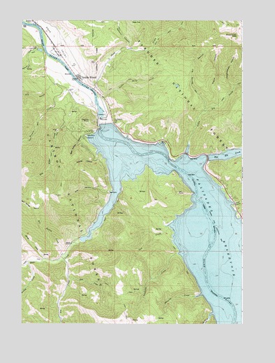
Palisades Dam, ID USGS Topographic Map
Click on map above to begin viewing in our Map Viewer.

This topographic map contains these locations and features:
Feature Name Type Latitude Longitude GNIS ID View Map
Bear CreekStreamN43.2844°W111.2163°377107View Map
Bear Wallow CanyonValleyN43.3263°W111.2169°377206View Map
Big Spring CreekStreamN43.2521°W111.1441°377599View Map
Booth CanyonValleyN43.2996°W111.1297°378032View Map
Calamity Guard StationLocaleN43.3294°W111.2091°378696View Map
Calamity PointSummitN43.3338°W111.2119°378698View Map
Camp Little LemhiLocaleN43.3633°W111.2413°378805View Map
Conglomerate CanyonValleyN43.3480°W111.1311°379617View Map
Coyote HollowValleyN43.3196°W111.2072°380000View Map
Deer FlatFlatN43.3749°W111.1849°380454View Map
Dry GulchValleyN43.3477°W111.2344°380874View Map
Edwards CreekStreamN43.2613°W111.1522°381262View Map
Edwards FerryLocaleN43.2666°W111.1433°399027View Map
Edwards Ferry (historical)LocaleN43.2666°W111.1433°399719View Map
Elbow CanyonValleyN43.3419°W111.1380°381299View Map
Elbow CreekStreamN43.3408°W111.1380°399035View Map
Elk CreekStreamN43.2763°W111.2263°381349View Map
First CanyonValleyN43.3044°W111.2002°381725View Map
Landslide CreekStreamN43.2791°W111.1619°384414View Map
Little Elk CreekStreamN43.3244°W111.1558°384822View Map
Little Sheep CreekStreamN43.3438°W111.2072°384943View Map
Muddy CreekStreamN43.2752°W111.2472°387366View Map
PalisadesPopulated PlaceN43.3519°W111.2177°397005View Map
Palisades CreekStreamN43.3735°W111.2447°388134View Map
Palisades DamDamN43.3327°W111.2024°388136View Map
Palisades ReservoirReservoirN43.3333°W111.2036°1604344View Map
Palisades Winter RangeReserveN43.3355°W111.1836°401099View Map
Pine CreekStreamN43.2699°W111.2244°388480View Map
Red Spring CreekStreamN43.2771°W111.2263°389242View Map
Russell CreekStreamN43.3463°W111.2247°389739View Map
Sawmill CanyonValleyN43.3646°W111.1894°389948View Map
Sheep CreekStreamN43.3469°W111.2097°390198View Map
Sheep Creek PeakSummitN43.3688°W111.1283°390221View Map
Spring CreekStreamN43.2771°W111.2372°391199View Map
Spring Run CanyonValleyN43.3388°W111.1463°391231View Map
Tag Alder CreekStreamN43.3405°W111.2186°391812View Map
Van CreekStreamN43.2894°W111.1661°392685View Map
Van PointSummitN43.3044°W111.1616°392694View Map
Yeaman CreekStreamN43.3649°W111.2394°393738View Map

Note: Coordinates in the location and feature list above are referenced to NAD83 datum.


Copyright (C) 2008-2025 Ryan Niemi / Sunset Dynamics ... All Rights Reserved